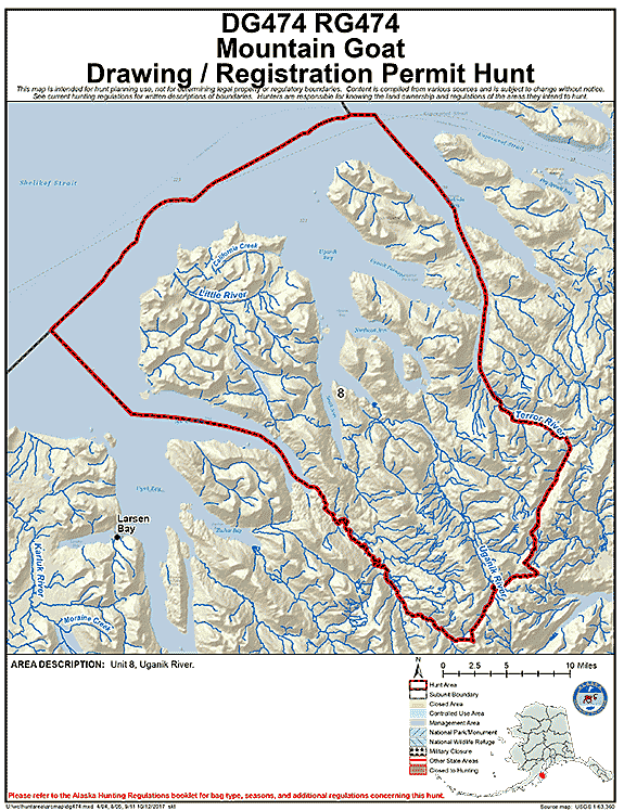
Kodiak Mountain Goat Hunting Area DG/RG 474
Uganik River
(USGS Maps - Kodiak B-4, C-4 & C-5)
Location:
Includes area west of Terror River, Terror Lake, and Terror headwaters to the west shore of Lake 2303 to the snowfield 1 mile west of Lake 2750. Southeastern boundary includes the headwaters of the Uganik River, which is located 1 mile west of Lake 2750 extending southwest down the valley in between Lake 1945 and mountain 3530 to the headwater of the Spiridon River. Southwestern boundary includes everything northeast of the Spiridon River, area also includes Spiridon Peninsula. See area map (Image file 109 kB) for more information.
Land Ownership:
Entire hunt area is managed by the U.S. Fish & Wildlife Refuge. www.dnr.alaska.gov/mlw/planning/easmtatlas/kodiak/.
Access:
Some of the most popular areas include the Terror Lake, Mount Glottof and the Uganik River Highlands. Some high mountain lakes that reside over 1900' are commonly frozen year round in this area.
Population Trend:
From 2013 to 2017 the population of goats in this area has ranged from 215 to 285 goats.
| Area | Hunt No. | Permits | % Draw (2017) |
|---|---|---|---|
| Uganik River | DG474 | 20 | 12% |
Mountain Goat Harvest Data:
DG474 (Draw Hunt)
| Year | Permits Issued | Hunters Afield | Harvest | % Success |
|---|---|---|---|---|
| 2017 | 50 | 29 | 20 total (19 male, 1 female) | 69% |
| 2016 | 50 | 25 | 22 total (15 male, 7 female) | 88% |
| 2015 | 50 | 24 | 17 total (10 male, 7 female) | 71% |
| 2014 | 40 | 24 | 12 total (8 male, 4 female) | 50% |
| 2013 | 40 | 14 | 9 total (2 male, 7 female) | 64% |
| 2012 | 40 | 17 | 8 total (6 male, 2 female) | 47% |
| 2011 | 30 | 12 | 9 total (8 male, 1 female) | 75% |
| 2010 | 30 | 10 | 5 total (4 male, 1 female) | 50% |
RG474 (Registration Hunt)
| Year | Permits Issued | Hunters Afield | Harvest | % Success |
|---|---|---|---|---|
| 2017 | 2 | 2 | 1 total (1 male) | 50% |
| 2016 | 0 | 0 | 0 | NA |
| 2015 | 2 | 0 | 0 | NA |
| 2014 | 0 | 0 | 0 | NA |
| 2013 | 0 | 0 | 0 | NA |
| 2012 | 0 | 0 | 0 | NA |
| 2011 | 1 | 1 | 1 total (1 male) | 100% |
| 2010 | 9 | 1 | 0 | 0% |