Kodiak and Alaska Peninsula/Aleutian Islands Management Area
Fishing Management - Kodiak Road System
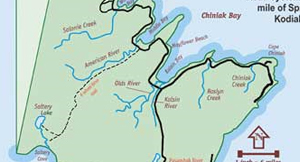 Kodiak Island road system is defined as all fresh waters of Kodiak Island east of a line from Craig Point south to the westernmost point of Saltery Cove, including freshwaters of Woody, Long and Spruce islands, as well as all saltwater bordering the road system within one mile of Spruce and Kodiak islands. The road system has approximately 70 miles of paved and hard-packed gravel roads crossing 10 significant streams and provides access to over 20 stocked lakes. A 13-mile gravel road leading to Saltery Cove requires 4-wheel-drive or use of an ATV.
The Road System streams and lakes provide fishing opportunities for salmon, Dolly Varden, rainbow trout and steelhead. Major waterways include the following streams: Buskin, Saltery, Pasagshak, Olds and American rivers, Roslyn, Salonie, Monashka, Pillar and Chiniak creeks. Anglers will find the road system streams a delight with no raging currents or 50-yard casts, just clear riffles alternating with deep pools and gravelly banks. However, some streams have abrupt and brushy banks.
Hip boots or chest waders are highly desirable while wading, which often provides the best access to the fish. Upstream of low-lying coastal areas, most road system rivers are braided, fast flowing, shallow and generally unsuitable for rafts, canoes, or other personal watercraft. However, a number of road-accessible lakes, such as Buskin, Kalsin Pond and Lake Rose Tead, which borders the Pasagshak State Recreation Area, are well suited for small rafts and float tubes.
Regulations on the road system differ slightly from Kodiak's Remote Zone, so check the regulations carefully.