Destinations
* Indicates historic canoe route access.
- Situk Lake
- Russell Fjord
- Harlequin Lake
- Ahrnklin River
- Situk River
- Strawberry Point *
- Tawah Creek Bridge *
- Tawah Creek at Cannon Bridge *
- Summit Lake *
- Yakutat Bay
- Ankau River/Estuary
- Disenchantment Bay
- Redfield Lakes
Additional Information
Yakutat Wildlife Viewing
Water Trails
Hundreds of miles of Yakutat area waterways, including rivers, fjords, estuaries, bays, and open waters, may be explored by canoe, kayak, raft, drift boat and motorized skiff. It’s as easy as renting a car, and perhaps a boat, and driving to any of several access points, most of which are relatively close to town. Some people also plan multi-day trips and camp along the way. In some areas, the U.S. Forest Service has cabins available for overnight use.
Some waterways have been used for centuries. The original inhabitants of the area, the Yakutat Kwaan, established a canoe trade route between Yakutat and Dry Bay of which Yakutat to Dry Bay Ancestral Lingit Canoe Route is the official name. A large portion of this historic route is passable between Summit Lake and the Ahrnklin River/Seal Creek estuary. This route may be accessed from several launch sites. Due to changes in topography and the river channels over time, however,travel beyond Ahrnklin River Delta is not recommended
Access to Water Trails
The starting point for the following directions to all destinations—trailheads, boat launches, etc—is the intersection of Forest Highway #10 (FH#10, also called the Dangerous River Road) and Airport Road in Yakutat. Driving distances listed on this site are one-way and approximate.
Strawberry Point at Ahrnklin/Situk Estuary
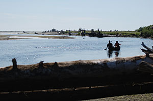
Directions to launch site at Strawberry Point: Drive 3 miles on Airport Road to Situk Landing Road. Turn right. Drive 8.7 miles to the Strawberry Point road sign, past the Maggie John Trailhead. Turn right at the sign and stay right at the Y in the road. Turn left onto the only road that parallels the beach/estuary. The road reaches a dead-end at 0.60 miles. Park and launch boats at this location.
Paddlers can launch boats into the Ahrnklin/Situk Estuary a short distance from the car. Check on the status of daily tides before paddling this area. Pay attention to private property markers. Be careful not to block roadways.
An optional launch site, especially for multi-day trips is Situk Landing. Strawberry Point is a short (approximately 0.5 mile) paddle downstream on the Situk River. To avoid the possibility of getting stranded, pay close attention to local tides.
Notes for water travelers: Paddlers have many one day or multi-day travel options from this launch site. The Situk, Ahrnklin/Seal Creek, and Lost River Deltas are all accessible from Strawberry Point. Black Sand Spit—home of one of the world’s largest nesting colony of Aleutian Terns—is a short paddle directly west from Strawberry Point. Be careful not to disturb the terns, especially during the breeding season from May through August. Paddlers can circumnavigate Black Sand Island through Black Sand Slough, a beautiful area for exceptional wildlife viewing. Pay close attention to tides.