Destinations
* Indicates historic canoe route access.
- Situk Lake
- Russell Fjord
- Harlequin Lake
- Ahrnklin River
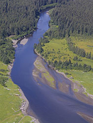
- Situk River
- Strawberry Point *
- Tawah Creek Bridge *
- Tawah Creek at Cannon Bridge *
- Summit Lake *
- Yakutat Bay
- Ankau River/Estuary
- Disenchantment Bay
- Redfield Lakes
Additional Information
Yakutat Wildlife Viewing
Water Trails
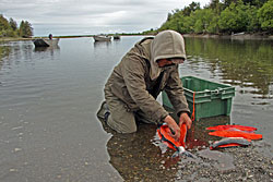
Hundreds of miles of Yakutat area waterways, including rivers, fjords, estuaries, bays, and open waters, may be explored by canoe, kayak, raft, drift boat and motorized skiff. It’s as easy as renting a car, and perhaps a boat, and driving to any of several access points, most of which are relatively close to town. Some people also plan multi-day trips and camp along the way. In some areas, the U.S. Forest Service has cabins available for overnight use.
Some waterways have been used for centuries. The original inhabitants of the area, the Yakutat Kwaan, established a canoe trade route between Yakutat and Dry Bay of which Yakutat to Dry Bay Ancestral Lingit Canoe Route is the official name. A large portion of this historic route is passable between Summit Lake and the Ahrnklin River/Seal Creek estuary. This route may be accessed from several launch sites. Due to changes in topography and the river channels over time, however,travel beyond Ahrnklin River Delta is not recommended
Access to Water Trails
The starting point for the following directions to all destinations—trailheads, boat launches, etc—is the intersection of Forest Highway #10 (FH#10, also called the Dangerous River Road) and Airport Road in Yakutat. Driving distances listed on this site are one-way and approximate.
Situk River
Directions to boat launch: Drive 9 miles on FH#10 to Nine Mile Bridge, which crosses the river. Parking is available on either side of the bridge. An unimproved boat ramp is provided by the USFS. Paddlers can launch boats at the boat ramp.
Notes for water travelers: Enjoy a 14-mile trip on the Situk River from Nine Mile Bridge to Situk Landing above Strawberry Point. Approximately three miles downriver are two USFS cabins available for public use. A car shuttle to Situk Landing at the mouth of the Situk River, or pick up, is required. Check with Yakutat lodges/lodging managers for assistance.