Southcentral Alaska Subsistence & Personal Use Fisheries
Closed Areas
In addition to the Nonsubsistence use areas listed below other specific areas are closed to subsistence and/or personal use fishing. For specific information on closures contact the local ADF&G office.
Anchorage-Matsu-Kenai Nonsubsistence Area
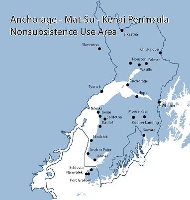
The Anchorage-Matsu-Kenai Nonsubsistence Area is comprised of the following: Units 7, as defined by 5 AAC 92.450(7) (except the Kenai Fjords National Park lands), 14, as defined by 5 AAC 92.450(14),15, as defined by 5 AAC 92.450(15) (except that portion south and west of a line beginning at the mouth of Rocky River up the Rocky and Windy Rivers across the Windy River/Jakolof Creek divide and down Jakolof Creek to its mouth, including the islands between the eastern most point of Jakolof Bay and the eastern most point of Rocky Bay), 16(A), as defined by 5 AAC 92.450(16) (A); all waters of Alaska in the Cook Inlet Area, as defined by 5 AAC 21.100 (except those waters north of Point Bede which are west of a line from the eastern most point of Jakolof Bay north to the western most point of Hesketh Island including Jakolof Bay and south of a line west from Hesketh Island; the waters south of Point Bede which are west of the eastern most point of Rocky Bay; and those waters described in 5 AAC 01.555(b), known as the Tyonek subdistrict).
Valdez Nonsubsistence Area
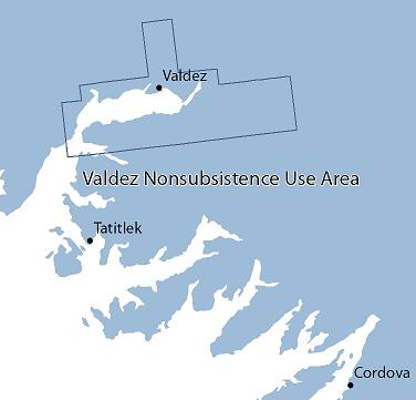
The Valdez Nonsubsistence Area is comprised of the following: within Unit 6(D), as defined by 5 AAC 92.450(6) (D), and all waters of Alaska in the Prince William Sound Area as defined by 5 AAC 24.100, within the March 1993 Valdez City limits.