Palmer Hay Flats —
State Game Refuge
Visitor Information
Access
The Palmer Hay Flats State Game Refuge is easily accessed from several locations and offers a variety of activities from leisure strolls to extended backcountry adventures. The Glenn Highway and Knik-Goose Bay Road offer the most convenient access to the Hay Flats. Parking areas, trails and waterways provide a means of enjoying the refuge. Please note that refuge access roads receive minimal maintenance and are not plowed during winter, so they may be impassible at times.
For all hunting and fishing activity, be sure to obtain a license and appropriate tags, and check the appropriate regulations.
Palmer Hay Flats locator map (PDF 180 kB)
Knik River Access and Reflections Lake
 Located at milepost 30.6 on the Glenn Highway (32 miles northeast of downtown Anchorage and 11 miles south of downtown
Palmer and Wasilla) this site is the most easily accessed area of the refuge.
Located at milepost 30.6 on the Glenn Highway (32 miles northeast of downtown Anchorage and 11 miles south of downtown
Palmer and Wasilla) this site is the most easily accessed area of the refuge.
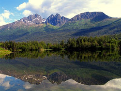
To reach this site, exit the Glenn Highway at the “Knik River Access” exit and follow the frontage road along the west side of the highway. A small parking area and short walk provide access to scenic Reflections Lake along the banks of the Knik River. A walk along the lakeshore is a good way to view upland birds as well as a few ducks and other waterbirds. The trail around the lake is scheduled for upgrades during 2008 to include a footbridge and will allow walkers to make a 1-mile loop around the entire lake with educational interpretive panels and rest stops. The Chugach Mountains provide a scenic backdrop to the lake and surrounding wetlands, and canoeing on the lake is becoming popular.
Anglers will sometimes wet a line in the lake but few fish are present. Fall waterfowl hunters are known to take a few ducks in the lake and surrounding wetlands; although the primary waterfowl hunting areas are farther afield in the wetlands.
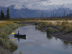
At the end of the frontage road, experienced boaters (primarily airboats and jetboats) often launch on the Knik River to hunt waterfowl downstream in the refuge or to venture upstream outside the refuge for various activities. Rafters and kayakers will occasionally pull out here after launching farther upstream, and kayakers sometimes launch here for trips downstream into the refuge. Note: due to changing tide levels, strong river currents, high winds and numerous navigation hazards including submerged gravel bars, only experienced boaters with local knowledge should attempt to operate boats on the Knik River.
Knik River access map (PDF 122 kB)
Rabbit Slough and Wasilla Creek
 This undeveloped site is accessed from the Trunk Road exit at milepost 35.5 on the Parks Highway, 6 miles east of downtown
Wasilla. Follow the frontage road on the south side of the highway to the east and south (as it becomes the frontage road
along the Glenn Highway) for 2 miles, where the frontage road ends. The access road, which may be impassible to 2-wheel
drive vehicles when wet, follows the forested banks of Rabbit Slough for ½ mile to its confluence with Wasilla Creek.
This undeveloped site is accessed from the Trunk Road exit at milepost 35.5 on the Parks Highway, 6 miles east of downtown
Wasilla. Follow the frontage road on the south side of the highway to the east and south (as it becomes the frontage road
along the Glenn Highway) for 2 miles, where the frontage road ends. The access road, which may be impassible to 2-wheel
drive vehicles when wet, follows the forested banks of Rabbit Slough for ½ mile to its confluence with Wasilla Creek.
This access is used primarily by boaters venturing downstream on Wasilla Creek to fish for coho salmon during the weekend-only sport fishery (5:00am to 10:00pm on Saturdays and Sundays only, closed April 15 – June 14) or to hunt waterfowl in the fall. During the weekend fishery, watercraft on Wasilla Creek are limited to motors of 3 horsepower or less (see current permit requirements).
Boaters (especially canoeists) are advised to consult a tide table prior to departure as the return trip against the stream’s current at low tide may be problematic. With proper planning, boaters may take advantage of the incoming tide which may slow the downstream current.
Rabbit Slough access map (PDF 229 kB)
Cottonwood Creek
 This area offers a diverse range of activities and is the most popular site in the refuge. Access is from a marked turnoff
along Hayfield Road located 1¼ miles from Fairview Loop Road. Access to Fairview Loop Road may be from Knik-Goose Bay Road
or the Parks Highway at the Hyer Road/Fairview Loop Road exit.
This area offers a diverse range of activities and is the most popular site in the refuge. Access is from a marked turnoff
along Hayfield Road located 1¼ miles from Fairview Loop Road. Access to Fairview Loop Road may be from Knik-Goose Bay Road
or the Parks Highway at the Hyer Road/Fairview Loop Road exit.
Waterfowl hunting is very popular during fall and hunters may travel by foot or on an off-road vehicle trail with ATVs weighing less than 1,000 pounds (check current permit requirements). The Cottonwood Creek wetlands are an excellent place to observe and photograph thousands of migrating ducks, geese and shorebirds during spring, starting in early April and lasting until late-May, with peak numbers typically occurring late-April to early-May. This is also a popular bird watching area during summer and during the fall southerly migration, although bird numbers are lower than during spring migration.
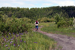
This part of the refuge also provides activities in an upland forested area. The Scout Ridge overlook is located an easy 400 yards along a surfaced trail suitable for access by wheelchairs. This covered overlook provides dramatic views of the Hay Flats, upper Cook Inlet and the Chugach Mountains. The Scout Ridge Nature Trail continues along the ridge line and makes a 1¼-mile loop back to the parking area while passing through birch forests and along portions of Cottonwood Creek and a forested pond. Upland birds including song birds and game birds are often spotted along this trail.
The lower 1 mile of Cottonwood Creek is open to salmon fishing (except king salmon) on weekends (Saturdays and Sundays only, 5:00am to 10:00pm, closed from April 15 to June 14). Several thousand people fish here each summer and catch primarily sockeye salmon and to a lesser extent, coho salmon.
Cottonwood Creek access map (PDF 172 kB)