Teller Highway
Mile 36–47 Feather River to Tisuk River Bridge
Habitat: Tundra meadow and dwarf tundra
As the Teller Highway skirts the western edge of the Kigluaik Range, it crosses higher and drier ground where plants and wildlife associated with dwarf tundra are found. The formidable mountain on the right has long been called Singatook by the local Inupiat but others refer to it as “38-70 or thirty-eight seventy,” after its elevation (3,870’ = 1,179.6 m). Because of its height and isolation from other tall peaks, it’s considered a “weather maker” — a place where clouds and precipitation gather. The King Islanders, who have a summer camp near here, talk of wolverine in this area. The landscape is open range to reindeer from herders based in Teller, and they use this range because caribou from the Western Arctic caribou herd seldom migrate to this area. The Kigluaik Mountains to the north and east seem to serve as a natural barrier that isolates this area from use by caribou. Along with reindeer, muskoxen are the most common large mammals found along this section of road.
Notable Wildlife
- Reindeer from domestic herds have open range in this area
- Muskoxen are sometimes seen on side slopes or ridges.
- Rock ptarmigan prefer upper rocky slopes and move to road edges for dust baths and fine gravel for their gizzards.
- Horned lark prefer drier, open meadows. Its “horns” are small dark feathers above the eye.
- American pipit and northern wheatear nest on high, dry ridges in this area.
King Island Views
On a clear day, the next several miles of road offer views of King Island, 40 miles off the coast. The island is ideally situated for harvesting the many seals and walruses that pass through the Bering Strait. Native people use the meat and blubber of seals and walrus for food, and oil for cooking and heating; ivory is carved into household and hunting implements and skins split and dried for use in construction of their homes and essential umiaqs. They also trade walrus skins to other mainland villages in exchange for the hides of caribou and furbearers. The King Islanders have long maintained a summer camp at Woolley Lagoon, where they continue to catch and dry salmon, and gather greens and berries.
According to Inupiat legend, King Island was once a huge fish caught up the Kuzitrin River and then towed out to sea. Its original name was Ukivok, and it was home to a village of approximately 200 people. When Captain Cook saw the island in 1778, he named it for his lieutenant, James King. In the early 1960s, social and economic pressures persuaded island residents to relocate to Nome, where they have continued to maintain a distinct cultural identity. Some still voyage to the island for spring hunting and to pick greens in summer, keeping alive the hope of once again moving back to their island.
Mile 40 Side Trip to Woolley Lagoon
Habitat types: Dwarf tundra, tundra meadow, and ponds
This road is a public right-of-way 100 feet across that traverses lands privately owned by the King Island Native Corporation. It runs eight miles to their traditional summer fishing camps at Woolley Lagoon. Please stay within 50 feet of either side of the road and do not travel close to the lagoon or summer camps. The King Islanders value their privacy and request that you do not take any photos of their campsites.
As you turn onto the Cape Woolley Road, a small pull-off immediately to your right is where King Islanders and many others driving the Teller Highway collect drinking water. Some believe this very clear stream holds healing powers. Moon Mountains, a unique limestone outcropping nearby is visible down the coast southeast of Cape Wooley. Several rare plants have been identified in this unique micro-habitat
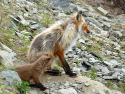
Notable Wildlife Along Cape Woolley Road
- Red fox feed on ground-nesting birds and abundant small rodents.
- Reindeer sometimes feed in area in small groups.
- Muskoxen sometimes winter on nearby Moon Mountains.
- Black-bellied plovers nests near end of road.
- Semipalmated plovers, Pacific golden-plovers, semipalmated sandpipers and western sandpipers are often found on river gravel bars.
- Red-necked phalarope are found in small ponds
- Pomarine, parasitic and long-tailed jaegers are found here.
- Northern wheatear form flocks of young birds in the fall.
- Lapland longspur nests and prefers to remain in open tundra meadows.
Mile 46.5 View of Raptor Nest
Habitats: Rock outcrop
As you approach the Tisuk River, scan downstream and across the river for a large nest of sticks built by golden eagles on an orange lichen-colored rock outcrop. If not occupied by eagles, gyrfalcons might use the nest.
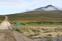
Mile 47 Tisuk River
Habitat: River valley and side slope
The Tisuk River valley near the bridge is subject to huge ice build-ups that extend over the gravel bars and riverbanks and are slow to melt in the spring. Because of the ice, this area is poor fish habitat and willow growth is sparse along the riverbanks.