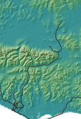
Kougarok Road (Nome–Taylor Highway)
Wildlife Viewing
The official name is the Nome-Taylor Highway, but local residents call this scenic well-maintained gravel road the Kougarok Road. That’s because the road ends at the Kougarok River Bridge, about 25 miles shy of Taylor. From there, it becomes a rough trail passable only by foot or All Terrain Vehicle (ATV). Don’t be fooled by maps that show the road continuing on to Taylor.
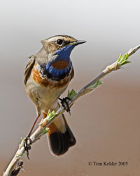
The Kougarok Road begins at the edge of the Bering Sea, 1.6 miles east of Nome, and heads north for approximately 86 miles. Bisecting the spectacular Kigluaik Range, it crosses clear flowing streams and offers views up glacially-carved valleys. Past Salmon Lake, the terminus of the northernmost red salmon run, the road moves into the rolling lowlands of the central Seward Peninsula. Birders often make this journey in search of the elusive bristle-thighed curlew and brightly-colored bluethroat.
Much of the highway parallels the route of an old rail bed. In the early 1900s the Seward Peninsula Railroad hauled passengers and freight from Nome to the gold fields in the peninsula’s interior. The railroad saw use into the late 1950s until construction of the highway in 1960 opened the region to automobiles. You can still spot trestles and tracks, although some of the tracks were sold to Disneyland in the early 1960s.
Some Tips for the Road
- Safety: Please don’t park on bridges. If you wish to view from a bridge, look for wide shoulders or a gravel pull-out for safe and easy parking.
- Binoculars: With all roads in the region, it is difficult to identify specific viewing locations for wildlife – particularly grizzlies, moose, muskoxen and reindeer, as these animals are wide-ranging and can be found in a number of habitats. While you may be treated to a close encounter, you will enhance your viewing opportunities tremendously by carrying binoculars and stopping to scan the surrounding countryside, especially in areas where there is a mix of habitat types.
- Orientation: The mileages listed are measured from the nearest green and white highway mileage markers generally placed at one mile intervals along the road. Some are missing, however, and the distance between them is not always exactly a mile but they remain the best point of reference.
- Private property: You will pass by areas with seasonal camps and year-round or seasonal homes. Please respect people’s privacy and keep in mind that, whether inhabited or not, they are private property.
- Mile 0 to 13
- Mile 13 to 31
- Mile 31 to 53
- Pilgrim Hot Springs
- Mile 58 to 67
- Mile 67 to 86
- Kougarok Bridge
Map of Kougarok Road
Kougarok Road by Milepost
- Nome to Nome River Bridge (Mile 0 to 13)
- Nome River to Nugget Divide (Mile 13 to 31)
- Nugget Divide to Golden Gate Pass (Mile 31 to 53)
- Side trip to Pilgrim Hot Springs (Mile 53)
- Golden Gate Pass to Kuzitrin River Bridge (Mile 58 to 67)
- Kuzitrin River to Kougarok River Bridge (Mile 67 to 86)
- Kougarok River Bridge (Mile 86)