Alaska Fish & Wildlife News
August 2015
Interactive Maps for Hunters
Work Without Internet
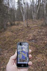
Hunters in Alaska have a new tool to keep them on track. Geo-referenced PDF maps for Alaska’s Game Management Units can be downloaded to a smartphone or mobile device with GPS capabilities, and the phone’s GPS will let you know where you are, even if you are not on a wireless or cellular network.
Hunting regulations vary between different Game Management Unit, and even between subunits. In addition, land status in parts of Alaska can be confusing, a patchwork of federal, state, borough, and private land managers. The geo-referenced maps now available have overlays showing land ownership or managers.
Meghan Nedwick initiated the project this spring when she was an education specialist with Fish and Game in Kotzebue. She wanted to provide good maps of land status in the Kotzebue area, GMU 23. She was updating a set of PDF maps for the Pilot Orientation Test that could viewed online or printed out when a colleague at the Bureau of Land Management suggested geo-referenced PDFs.
“I wasn’t familiar with geo-referenced PDF’s and was skeptical that it would work, especially out here,” she said. “I downloaded PDF Maps to my mobile and imported the land status maps. I decided to try it out, we flew out to our cabin east of Kotzebue where there is no internet or cell coverage, and it worked. I couldn’t wait to get back and share this with others.”
Ken Marsh tested the map of Anchorage and reported, “It works. Took me a bit to figure out how to use the app - though turns out it’s pretty easy. My iPhone screen shows a map of area with the subunit, park and management boundaries, and my location.”
Hunters can also download maps and print them out.
There are a few caveats. Land status changes, so be sure to download new maps as they become available. These maps are intended for hunt planning use, not for determining legal property or regulatory boundaries. The content is compiled from various sources and is subject to change without notice. See the current hunting regulations for written descriptions of boundaries. Hunters are responsible for knowing the land ownership and regulations of the areas they intend to hunt.
How to do it
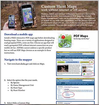
The Fish and Game website has a step by step instruction sheet.
You start by downloading an interactive PDF maps application. This can be done by visiting the app store for your device, or by searching the internet for a geospatial PDF phone app. There are a variety of applications reading geospatial PDFs. Some are free. Some apps reading a geospatial PDF work without internet connection on your phone, that’s what you want. ADF&G can’t endorse a specific product, but we use PDF Maps Avenza as an example in these instructions.
Once you’ve downloaded the reader, Visit www.hunt.alaska.gov and click on maps. Click on each of the PDF maps you want one at a time. There may be several for each GMU. Following the instructions, depending on the app you have chosen, for obtaining the maps. Maps will automatically download in the App.
Make sure each of the maps have been added to the application.
You do need to be on a wireless network to download the maps. Once they are on your phone, you do not need to be on a wireless network to use them.
You should test to be sure the application reading the geospatial PDF works without internet connection on your phone. You should be able to turn wifi off and turn on airplane mode, refresh the app, and see where you are at.
Once in the field, open your app and it will notify you which map you are on and will show your location as a blue dot.
Hunting Maps & Area Information Page
Subscribe to be notified about new issues
Receive a monthly notice about new issues and articles.