Maps & GIS
Overview
 These pages provide a central location for finding maps, GIS data, and mobile web applications currently available throughout the ADF&G website. Some new resources include interactive mapping applications that allow you to create a custom hunt map to print or use on a mobile device. Geographic Information Systems (GIS) data are also available for download.
Feature Map
Fish Resource Monitor
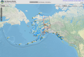
Featured Map: The Fish Resource Monitor is an interactive map has 3 options for users: find mapped salmon streams and lakes, fish passage or culvert inventory data and the freshwater fish species location data.
Contact GIS Staff
Have questions on maps or GIS data? Contact our ADF&G GIS Staff: Wildlife Conservation, Commercial Fisheries or Sport Fish.