Maps & GIS
Overview
 These pages provide a central location for finding maps, GIS data, and mobile web applications currently available throughout the ADF&G website. Some new resources include interactive mapping applications that allow you to create a custom hunt map to print or use on a mobile device. Geographic Information Systems (GIS) data are also available for download.
Feature Map
Anchorage Urban Bears
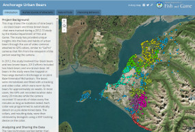
Featured Map: The Anchorage Bears Story Map allows users to explore the daily lives of six urban bears with an interactive map of location data and video over two summers.
Contact GIS Staff
Have questions on maps or GIS data? Contact our ADF&G GIS Staff: Wildlife Conservation, Commercial Fisheries or Sport Fish.