Areas With Restrictions
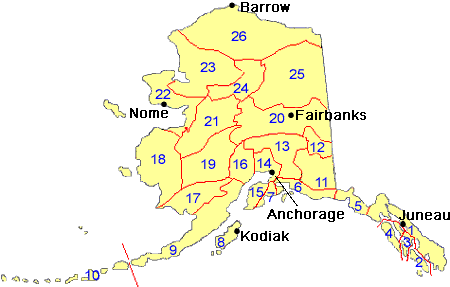
Search By Game Management
Unit (GMU)
Note: Use of these maps indicates that you have read and understand the liability statement.
Select a Game Management Unit.
Game Management Unit
Results for Game Management Unit 15
The following restrictions are those specific to GMU 15. Be sure to check the hunting regulations for additional state-wide hunting and trapping restrictions.
Areas Closed to Hunting
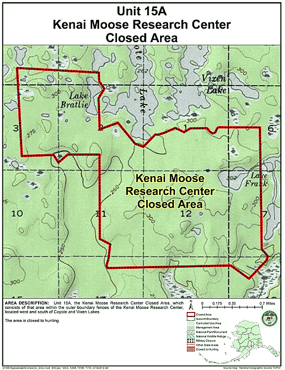
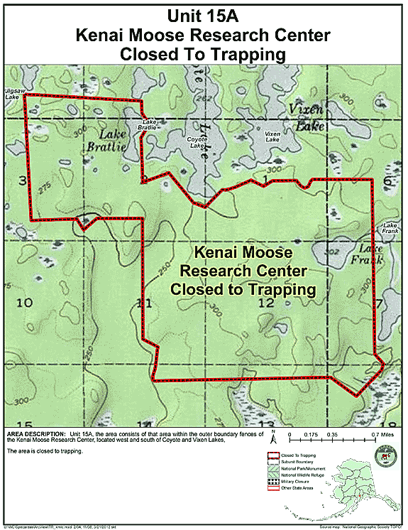
Kenai Moose Research Center Closed Area
- Restriction: Closed to hunting
- View Map: GIF Map (118 K) PDF Map (199 K)
- Area Description: Unit 15 the Kenai Moose Research Center Closed Area in Unit 15(A), which consists of that area within the outer boundary fences of the Kenai Moose Research Center, located west and south of Coyote and Vixen Lakes
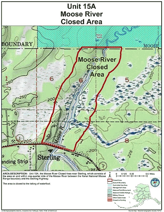
Moose River Closed Area
- Restriction: Closed to the taking of waterfowl
- View Map: GIF Map (117 K) PDF Map (235 K)
- Area Description: Unit 15 the Moose River Closed Area near Sterling in Unit 15(A), which consists of the area on and within one-quarter mile of the Moose River between the Kenai National Moose Range boundary and the Sterling Highway
Controlled Use Areas
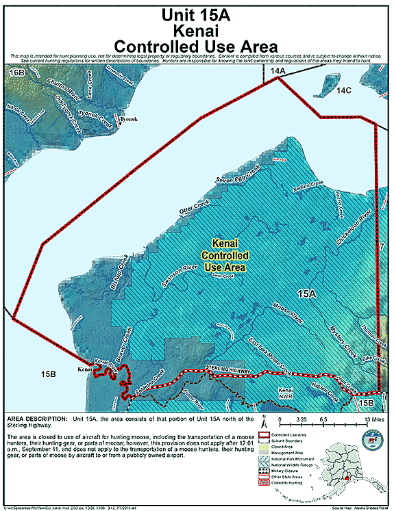
Kenai Controlled Use Area
- Restriction: Closed to use of aircraft for hunting moose, including the transportation of a moose hunters, their hunting gear, or parts of moose; however, this provision does not apply after 12:01 a.m., September 11, and does not apply to the transportation of a moose hunters, their hunting gear, or parts of moose by aircraft to or from a publicly owned airport
- View Map: GIF Map (90 K) PDF Map (437 K)
- Area Description: The Kenai Controlled Use Area: the area consists of that portion of Unit 15(A) north of the Sterling Highway
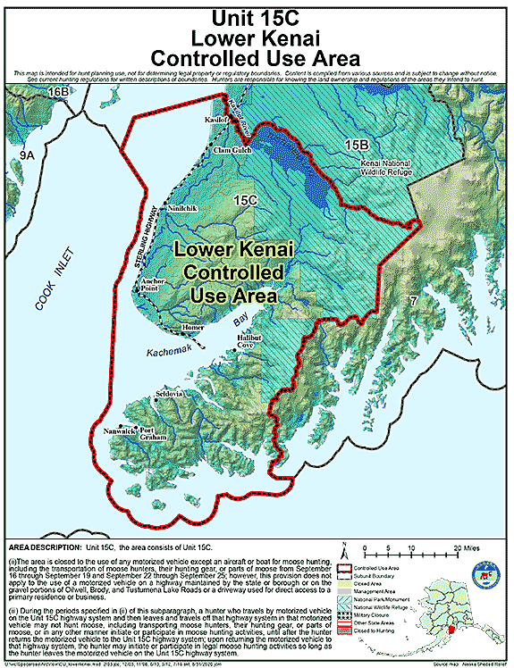
Lower Kenai Controlled Use Area
- Restriction: A. The area is closed to the use of any motorized vehicle (except an aircraft or boat) for big game hunting, including the transportation of big game hunters, their hunting gear, or parts of big game from September 16 through September 19 and September 22 through September 25; however, this provision does not apply to the use of a motorized vehicle on a platted and improved (graveled, asphalted, or paved) borough, state, or municipal roads, or driveways used for direct access to a primary residence or business
B. During the periods specified in (ii) of this subparagraph, a hunter who travels by motorized vehicle on the Unit 15(C) highway system and then leaves and travels off that highway system in that motorized vehicle may not hunt big game, including transporting big game hunters, their hunting gear, or parts of big game, or in any other manner initiate or participate in big game hunting activities, until after the hunter returns the motorized vehicle to the Unit 15(C) highway system; upon returning the motorized vehicle to that highway system, the hunter may initiate or participate in legal big game hunting activities so long as the hunter leaves the motorized vehicle on the Unit 15(C) highway system ; - View Map: GIF Map (98 K) PDF Map (447 K)
- Area Description: The Lower Kenai Controlled Use Area: that portion of Unit 15C north of Kachemak Bay, Kachemak Creek, Bradley River, and Bradley Lake
Management Areas
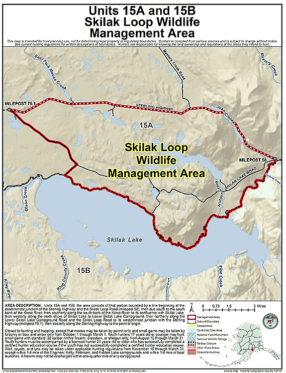
Skilak Loop Wildlife Management Area
- Restriction: Closed to hunting and trapping, except that moose may be taken by permit only and small game may be taken by falconry or bow and arrow only from October 1 through March 1.
Youth hunters 17 years old or younger may hunt small game with standard .22 caliber rimfire firearm, crossbow, or shotgun only, from August 10 through March 31. Youth hunters must be accompanied by a licensed hunter 21 years old or older who has successfully completed a certified hunter education course if the youth has not successfully completed a certified hunter education course.
Wolf, coyote, and lynx may be taken under applicable hunting regulations from November 10 through March 31, except within 1/4 mile of the Engineer, Kelly, Petersen, and Hidden Lake campgrounds and within 1/4 mile of boat launches. A firearm may not be discharged within one-quarter mile of any campground. - View Map: GIF Map (105 K) PDF Map (289 K)
- Area Description: Skilak Loop Wildlife Management Area: the area consists of that portion of Units 15(A) and 15(B) bounded by a line beginning at the easternmost junction of the Sterling Highway and the Skilak Loop Road (milepost 58), then due south to the south bank of the Kenai River, then southerly along the south bank of the Kenai River to its confluence with Skilak Lake, then westerly along the north shore of Skilak Lake to Lower Skilak Lake Campground, then northerly along the Lower Skilak Lake Campground Road and the Skilak Loop Road to its westernmost junction with the Sterling Highway (milepost 75.1), then easterly along the Sterling Highway to the point of origin
Areas Closed to Trapping
Unit 15A, Kenai Moose Research Center Closed Area
- Restriction: Closed to trapping
- View Map: GIF Map (115 K) PDF Map (204 K)
- Area Description: The Kenai Moose Research Center Closed Area in Unit 15(A), which consists of that area within the outer boundary fences of the Kenai Moose Research Center, located west and south of Coyote and Vixen Lakes
Note: Changes to area restrictions for hunting and trapping by Emergency Orders may not be shown on this page. Please be sure to check the Emergency Orders page for the most current list of changes.