Areas Closed to Hunting
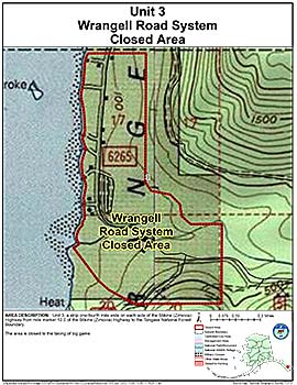
Wrangell Road System Closed Area
Note: Use of these maps indicates that you have read and understand the liability statement.
Units: 03
Area Description: Unit 3 a strip one-fourth mile wide on each side of the Stikine (Zimovia) Highway from mile marker 12.0 of the Stikine (Zimovia) Highway to the Tongass National Forest Boundary
Restrictions: Closed to the taking of big game;