Areas With Restrictions
Search By Game Management
Unit (GMU)
Note: Use of these maps indicates that you have read and understand the liability statement.
Select a Game Management Unit.
Game Management Unit
Results for Game Management Unit 13
The following restrictions are those specific to GMU 13. Be sure to check the hunting regulations for additional state-wide hunting and trapping restrictions.
Areas Closed to Hunting
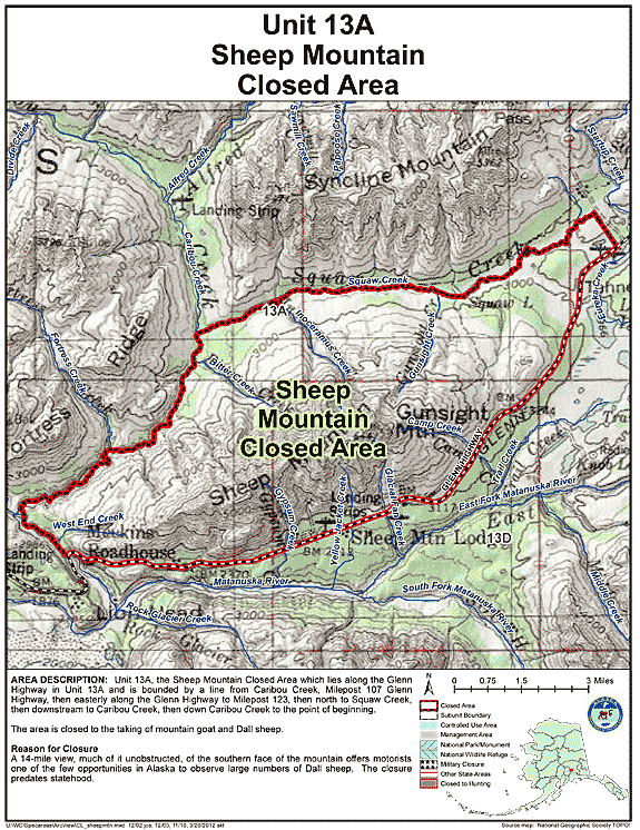
Sheep Mountain Closed Area
- Restriction: Closed to the taking of mountain goat and Dall sheep
- View Map: GIF Map (155 K) PDF Map (432 K)
- Area Description: Unit 13 the Sheep Mountain Closed Area which lies along the Glenn Highway in Unit 13(A) and is bounded by a line from Caribou Creek, Milepost 107 Glenn Highway, then easterly along the Glenn Highway to Milepost 123, then north to Squaw Creek, then downstream to Caribou Creek, then down Caribou Creek to the point of beginning
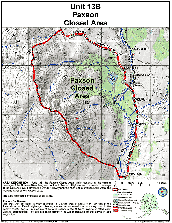
Paxson Closed Area
- Restriction: Closed to the taking of big game
- View Map: GIF Map (136 K) PDF Map (271 K)
- Area Description: Unit 13 the Paxson Closed Area in Unit 13(B), which consists of the eastern drainage of the Gulkana River lying west of the Richardson Highway and the western drainage of the Gulkana River between the Denali Highway and the north end of Paxson Lake where the Gulkana River enters Paxson Lake
Controlled Use Areas
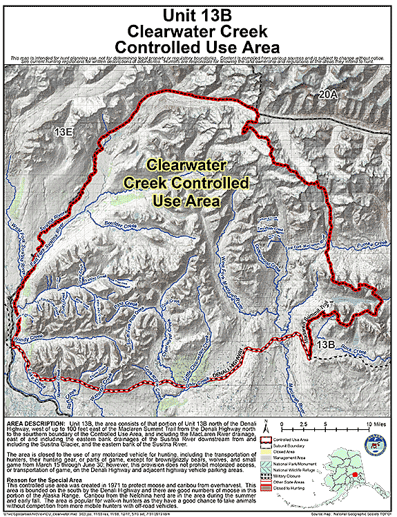
Clearwater Creek Controlled Use Area
- Restriction: Closed to the use of any motorized vehicle for hunting, including the transportation of hunters, their hunting gear, or parts of game, except for brown/grizzly bears, wolves, and small game from March 15 through June 30; however, this provision does not prohibit motorized access, or transportation of game, on the Denali Highway and adjacent highway vehicle parking areas
- View Map: GIF Map (154 K) PDF Map (455 K)
- Area Description: Unit 13B, the area consists of that portion of Unit 13B north of the Denali Highway, west of up to 100 feet east of the Maclaren Summit Trail from the Denali Highway north to the sourthern boundary of the Controlled Use Area, and including the Maclaren River drainage, east of and including the eastern bank drainages of the Susitna River downstream from and including the Susitna Glacier, and the eastern bank of the Susitna River.
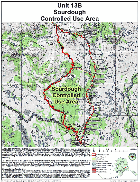
Sourdough Controlled Use Area
- Restriction: Closed to the use of any motorized vehicle for hunting, including the transportation of hunters, their hunting gear, or parts of game; however, this provision does not prohibit motorized access, or transportation of game, on the Richardson Highway, Gulkana River, Sourdough Creek Campground or boat launch, Sourdough and Haggard Creeks, Middle Fork and Haggard Creek trails, or other trails designated by the department
- View Map: GIF Map (146 K) PDF Map (429 K)
- Area Description: The Sourdough Controlled Use Area: the area consists of that portion of Unit 13(B) bounded by a line beginning at the confluence of Sourdough Creek and the Gulkana River, then northerly along Sourdough Creek to approximately mile 148 of the Richardson Highway, then northerly along the Richardson Highway to the Middle Fork Trail at approximately mile 170 of the Richardson Highway, then westerly along the trail to the Gulkana River, then southerly along the east bank of the Gulkana River to its confluence with Sourdough Creek, the point of beginning
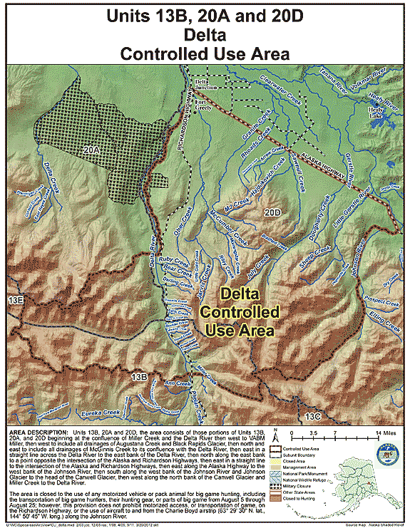
Delta Controlled Use Area
- Restriction: Closed to the use of any motorized vehicle or pack animal for big game hunting, including the transportation of big game hunters, their hunting gear, or parts of big game from August 5 through August 25; however, this provision does not prohibit motorized access, or transportation of game, on the Richardson Highway, or the use of aircraft to and from the Charlie Boyd airstrip (63° 29' 30N. lat., 144° 50' 45"W. long.) along the Johnson River
- View Map: GIF Map (145 K) PDF Map (487 K)
- Area Description: Units 13 and 20; the area consists of those portions of Units 13(B), 20(A), and 20(D) beginning at the confluence of Miller Creek and the Delta River then west to VABM Miller, then west to include all drainages of Augustana Creek and Black Rapids Glacier, then north and east to include all drainages of McGinnis Creek to its confluence with the Delta River, then east in a straight line across the Delta River to the east bank of the Delta River, then north along the east bank to a point opposite the intersection of the Alaska and Richardson Highways, then east in a straight line to the intersection of the Alaska and Richardson Highways, then east along the Alaska Highway to the west bank of the Johnson River, then south along the west bank of the Johnson River and Johnson Glacier to the head of the Canwell Glacier, then west along the north bank of the Canwell Glacier and Miller Creek to the Delta River
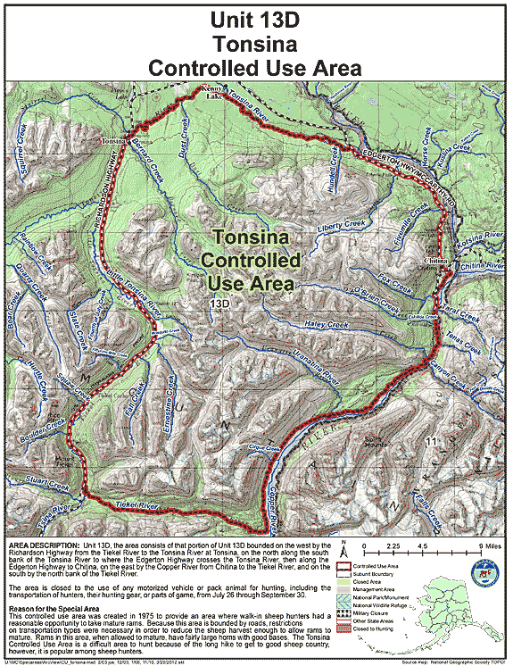
Tonsina Controlled Use Area
- Restriction: Closed to the use of any motorized vehicle or pack animal for hunting, including the transportation of hunters, their hunting gear, or parts of game, from July 26 through September 30
- View Map: GIF Map (154 K) PDF Map (571 K)
- Area Description: The Tonsina Controlled Use Area: the area consists of that portion of Unit 13(D) bounded on the west by the Richardson Highway from the Tiekel River to the Tonsina River at Tonsina, on the north along the south bank of the Tonsina River to where the Edgerton Highway crosses the Tonsina River, then along the Edgerton Highway to Chitina, on the east by the Copper River from Chitina to the Tiekel River, and on the south by the north bank of the Tiekel River
Management Areas
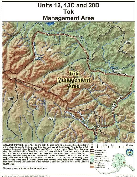
Tok Management Area
- Restriction: Open to sheep hunting by permit only
- View Map: GIF Map (144 K) PDF Map (459 K)
- Area Description: Tok Management Area: the area consists of those portions of Units 12, 13(C), and 20(D) bounded by a line along the Alaska Highway east from the west side of the Johnson River bridge to Tok Junction, then south along the Tok-Slana cutoff (Glenn Highway) to the Slana River; then west along the north bank of the Slana River to its confluence with Lost Creek, then up the north side of Lost Creek to the divide between Lost Creek and Jack Creek, then north to the Unit 12 boundary, then west along the Unit 12 boundary to Mount Kimball (63° 17' N. lat., 144° 40' W. long.), then west in a straight line to Mount Gakona (63° 17' N. lat., 145° 12' W. long.), then southwesterly to the head of Canwell Glacier, then northerly to the head of the Johnson Glacier, then northerly along the west bank of the Johnson Glacier and Johnson River to the Johnson River bridge
Note: Changes to area restrictions for hunting and trapping by Emergency Orders may not be shown on this page. Please be sure to check the Emergency Orders page for the most current list of changes.