Areas With Restrictions
Search By Game Management
Unit (GMU)
Note: Use of these maps indicates that you have read and understand the liability statement.
Select a Game Management Unit.
Game Management Unit
Results for Game Management Unit 4
The following restrictions are those specific to GMU 4. Be sure to check the hunting regulations for additional state-wide hunting and trapping restrictions.
Areas Closed to Hunting
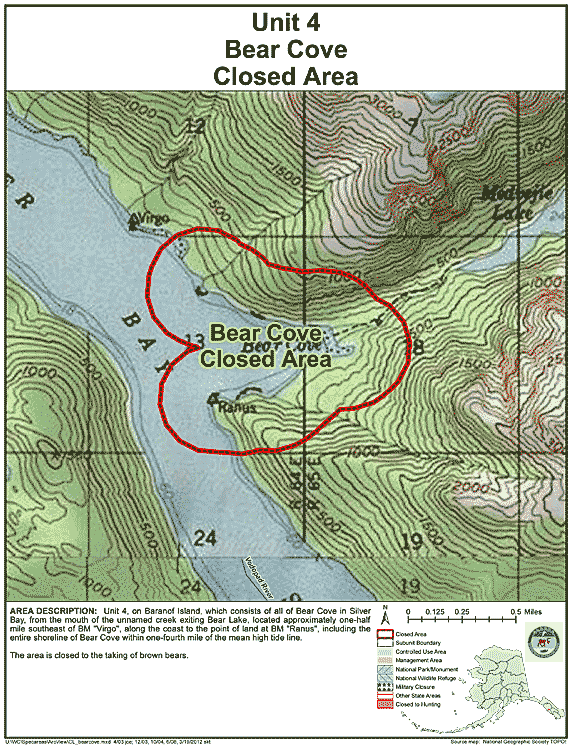
Bear Cove Closed Area (Baranof Island)
- Restriction: Closed to the taking of brown bears
- View Map: GIF Map (133 K) PDF Map (244 K)
- Area Description: Unit 4 Bear Cove Closed Area (Baranof Island): the area consists of all of Bear Cove in Silver Bay, from the mouth of the unnamed creek exiting Bear Lake, located approximately one-half mile southeast of BM "Virgo", along the coast to the point of land at BM "Ranus," including the entire shoreline of Bear Cove within one-fourth mile of the mean high tide line
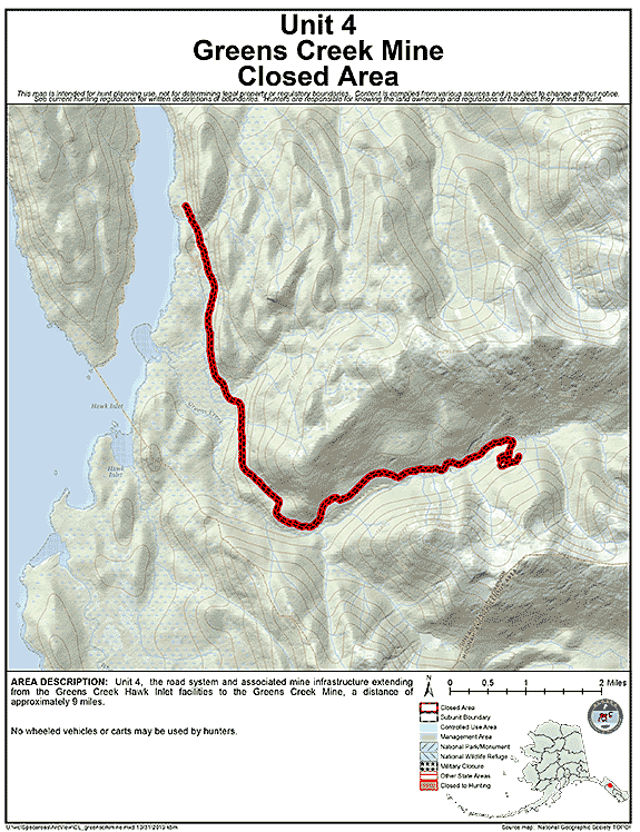
Greens Creek Mine Closed Area
- Restriction: No wheeled vehicles or carts may be used by hunters
- View Map: GIF Map (121 K) PDF Map (276 K)
- Area Description: Unit 4 - The road system and associated mine infrastructure extending from the Greens Creek Hawk Inlet facilities to the Greens Creek Mine, a distance of approximately 9 miles
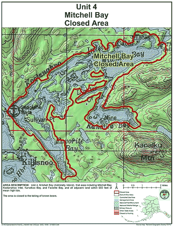
Mitchell Bay Closed Area
- Restriction: Closed to the taking of brown bears
- View Map: GIF Map (143 K) PDF Map (340 K)
- Area Description: Unit 4 Mitchell Bay (Admiralty Island), that area including Mitchell Bay, Kootznahoo Inlet, Kanalkoo Bay, and Favorite Bay, and all adjacent land within 660 feet of mean high tide
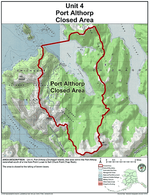
Port Althorp Closed Area
- Restriction: Closed to the taking of brown bears
- View Map: GIF Map (121 K) PDF Map (283 K)
- Area Description: Unit 4 Port Althorp (Chichagof Island), that area within the Port Althorp watershed south of a line from Point Lucan to Salt Chuck Point (Trap Rock)
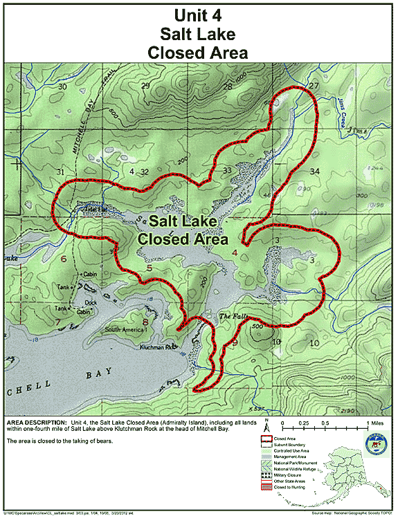
Salt Lake Closed Area
- Restriction: Closed to the taking of bears
- View Map: GIF Map (136 K) PDF Map (243 K)
- Area Description: Unit 4 the Salt Lake Closed Area (Admiralty Island), including all lands within one-fourth mile of Salt Lake above Klutchman Rock at the head of Mitchell Bay
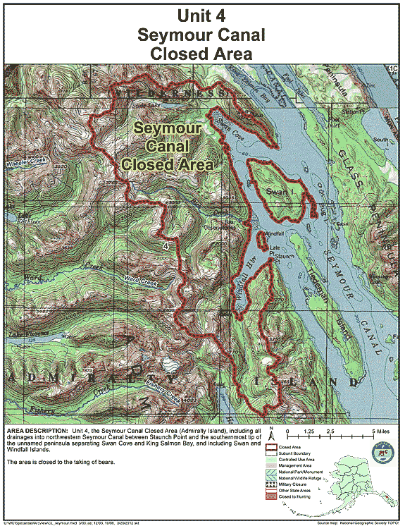
Seymour Canal Closed Area
- Restriction: Closed to the taking of bears
- View Map: GIF Map (156 K) PDF Map (459 K)
- Area Description: Unit 4 the Seymour Canal Closed Area (Admiralty Island), including all drainages into northwestern Seymour Canal between Staunch Point and the southernmost tip of the unnamed peninsula separating Swan Cove and King Salmon Bay, and including Swan and Windfall Islands
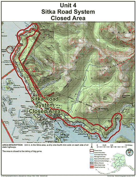
Sitka Road System Closed Area
- Restriction: Closed to the taking of big game
- View Map: GIF Map (142 K) PDF Map (395 K)
- Area Description: Unit 4 in the Sitka area, a strip one-fourth mile wide on each side of all state highways
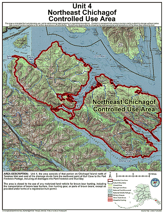
Controlled Use Areas
Northeast Chichagof Controlled Use Area
- Restriction: Closed to the use of any motorized land vehicle for brown bear hunting, including the transportation of brown bear hunters, their hunting gear, or parts of brown bears, except as provided under terms of a registration hunt permit
- View Map: GIF Map (142 K) PDF Map (579 K)
- Area Description: Unit 4, the area consists of that portion of Unit 4 on Chichagof Island north of Tenakee Inlet and east of the drainage divide from the northwest point of Gull Cove to the Port Frederick Portage, including all drainages into Port Frederick and Mud Bay
Note: Changes to area restrictions for hunting and trapping by Emergency Orders may not be shown on this page. Please be sure to check the Emergency Orders page for the most current list of changes.