Management Areas
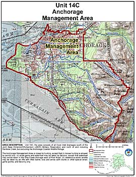
Anchorage Management Area
Note: Use of these maps indicates that you have read and understand the liability statement.
Units: 14C
Area Description: The Anchorage Management Area: the area consists of all Cook Inlet drainages south of the Elmendorf and Fort Richardson military reservations and north of and including Rainbow Creek, but excluding the Anchorage Coastal Wildlife Refuge
Restrictions: Closed to hunting, except that (i) moose hunting is allowed by permit only; (ii) small game and waterfowl may be taken by falconry, except that waterfowl may not be taken in the Ship Creek drainage west of Post Road; (iii) deleterious exotic wildlife may be taken by air rifle with rifled barrel, bow and arrow (with blunts or other special small-game points), and falconry only