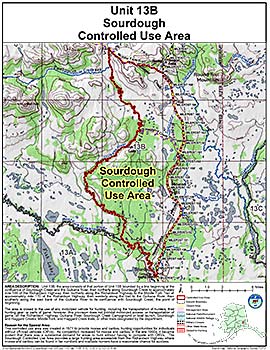
Controlled Use Areas
Sourdough Controlled Use Area
Note: Use of these maps indicates that you have read and understand the liability statement.
Units: 13B
Area Description: The Sourdough Controlled Use Area: the area consists of that portion of Unit 13(B) bounded by a line beginning at the confluence of Sourdough Creek and the Gulkana River, then northerly along Sourdough Creek to approximately mile 148 of the Richardson Highway, then northerly along the Richardson Highway to the Middle Fork Trail at approximately mile 170 of the Richardson Highway, then westerly along the trail to the Gulkana River, then southerly along the east bank of the Gulkana River to its confluence with Sourdough Creek, the point of beginning
Restrictions: Closed to the use of any motorized vehicle for hunting, including the transportation of hunters, their hunting gear, or parts of game; however, this provision does not prohibit motorized access, or transportation of game, on the Richardson Highway, Gulkana River, Sourdough Creek Campground or boat launch, Sourdough and Haggard Creeks, Middle Fork and Haggard Creek trails, or other trails designated by the department