Controlled Use Areas
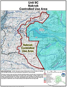
Naknek Controlled Use Area
Note: Use of these maps indicates that you have read and understand the liability statement.
Units: 09C
Area Description: Naknek Controlled Use Area: the area consists of that portion of Unit 9(C) within the Naknek River drainage upstream from and including the King Salmon Creek drainage
Restrictions: Closed to the use of any motorized vehicle except an aircraft, boat, or snowmachine for hunting, including the transportation of hunters, their hunting gear, or parts of game, from August 1 through November 30; however, this provision does not apply to a motorized vehicle on the Naknek-King Salmon, Lake Camp, and Rapids Camp roads, and on the Pike Ridge and King Salmon Creek trails, and on frozen surfaces of the Naknek River and Big Creek