Controlled Use Areas
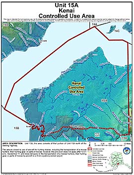
Kenai Controlled Use Area
Note: Use of these maps indicates that you have read and understand the liability statement.
Units: 15A
Area Description: The Kenai Controlled Use Area: the area consists of that portion of Unit 15(A) north of the Sterling Highway
Restrictions: Closed to use of aircraft for hunting moose, including the transportation of a moose hunters, their hunting gear, or parts of moose; however, this provision does not apply after 12:01 a.m., September 11, and does not apply to the transportation of a moose hunters, their hunting gear, or parts of moose by aircraft to or from a publicly owned airport