Controlled Use Areas
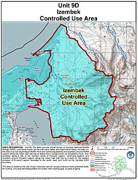
Izembek Controlled Use Area
Note: Use of these maps indicates that you have read and understand the liability statement.
Units: 09
Area Description: Izembek Controlled User Area: the area consists of that portion of Izembek National Wildlife Refuge (NWR), commonly known as the Left Hand Valley and Right Hand Valley, bounded on the west by a line beginning at Moffet Point and continuing easterly and southerly around Moffet Lagoon along the mean high tide line to Blaine Point (locally known as Strawberry Point), then southerly along a line to the northern shore of Kinzarof Lagoon, continuing easterly and southerly around Kinzarof Lagoon along the mean high tide line to a point on the eastern entrance of Kinzarof Lagoon; bounded to the south, east, and north by the Izembek NWR boundary
Restrictions: Closed to the use of any motorized vehicle, except outboard motor-powered boats, for hunting, including the transportation of hunters, their hunting gear, or parts of game