Areas Closed to Trapping
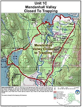
Unit 1(C) Mendenhall Valley
Note: Use of these maps indicates that you have read and understand the liability statement.
Units: 01C
Area Description: Unit 1(C) that area of the Mendenhall Valley bounded on the south by the Glacier Highway, on the west by the Mendenhall Loop Road and Montana Creek Road and Spur Road to Mendenhall Lake, on the north by Mendenhall Lake, and on the east by the Mendenhall Loop Road and Forest Service Glacier Spur Road to the Forest Service Visitor Center
Restrictions: Closed to the trapping of furbearers