Areas Closed to Trapping
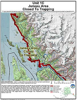
Unit 1(C) Juneau Area
Note: Use of these maps indicates that you have read and understand the liability statement.
Units: 01C
Area Description: Unit 1(C) (Juneau area): a strip within one-quarter mile of the mainland coast between the end of Thane Road and the end of Glacier Highway at Echo Cove
Restrictions: The area is closed to the trapping of furbearers; except the use of completely submerged traps is allowed within one-quarter mile of the following trails: Herbert Glacier Trail, Windfall Lake Trail, Peterson Lake Trail, Spaulding Meadows Trail (including the loop trail), Nugget Creek Trail, Outer Point Trail, Dan Moller Trail,