Areas Closed to Hunting
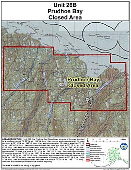
Prudhoe Bay Closed Area
Note: Use of these maps indicates that you have read and understand the liability statement.
Units: 26
Area Description: Unit 26 the Prudhoe Bay Closed Area is closed to the taking of big game; this closed area consists of the area bounded by a line beginning at 70° 22' N. lat., 148° W. long., then running south approximately 14 miles to a point at 70° 10' N. lat., 148° W. long., then west approximately 15 miles to a point at 70° 10' N. lat., 148° 40' W. long., then north approximately two miles to a point at 70° 12' N. lat., 148° 40' W. long., then west approximately eight miles to a point at 70° 12' N. lat., 148° 56' W. long., then north approximately two miles to a point at 70° 15' N. lat., 148° 56' W. long., then west approximately 12 miles to a point at 70° 15' N. lat., 149° 28' W. long., then north approximately 12 miles to a point at 70° 26' N. lat., 149° 28' W. long., then east approximately 14 miles to a point at 70° 26' N. lat., 148° 52' W. long., then south approximately two miles to a point at 70° 24' N. lat., 148° 52' W. long., then east approximately 16 miles to a point at 70° 24' N. lat., 148° 11' W. long., then south approximately two miles to a point at 70° 24' N. lat., 148° 11' W. long., then east approximately six miles to the point of beginning
Restrictions: Closed to the taking of big game