Areas Closed to Hunting
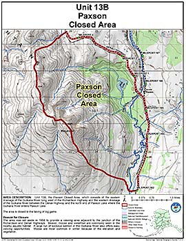
Paxson Closed Area
Note: Use of these maps indicates that you have read and understand the liability statement.
Units: 13B
Area Description: Unit 13 the Paxson Closed Area in Unit 13(B), which consists of the eastern drainage of the Gulkana River lying west of the Richardson Highway and the western drainage of the Gulkana River between the Denali Highway and the north end of Paxson Lake where the Gulkana River enters Paxson Lake
Restrictions: Closed to the taking of big game