Areas Closed to Hunting
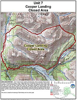
Cooper Landing Closed Area
Note: Use of these maps indicates that you have read and understand the liability statement.
Units: 07
Area Description: Unit 7 the Cooper Landing Closed Area, which consists of that portion of Unit 7 bounded by Juneau Creek, beginning at its confluence with the Kenai River, then upstream to the confluence of Juneau Creek and Falls Creek, then easterly along Falls Creek and the north fork of Falls Creek and over the connecting saddle to Devils Creek, then southeasterly along Devils Creek to its confluence with Quartz Creek, then southwesterly along Quartz Creek to the Sterling Highway, then westerly along the Sterling Highway to the Kenai River, and then westerly along the Kenai River to the point of beginning at the mouth of Juneau Creek
Restrictions: Closed to the taking of Dall sheep and mountain goat