Permafrost
 If you dig down through the arctic tundra, you'll soon strike a rock-like layer of frozen soil.
Even on the warmest summer day, this permafrost layer lies anywhere from a few inches to a few feet below the tundra surface,
never thawing. About 85% of Alaska's land area is underlain by permafrost.
If you dig down through the arctic tundra, you'll soon strike a rock-like layer of frozen soil.
Even on the warmest summer day, this permafrost layer lies anywhere from a few inches to a few feet below the tundra surface,
never thawing. About 85% of Alaska's land area is underlain by permafrost.
Permafrost is a powerful influence on tundra life. In summer, it traps a layer of water close to the surface, keeping many tundra soils soggy. It cools the soil and the roots of tundra plants, slowing decomposition and growth. Its presence influences freeze-thaw cycles, forming unique tundra landforms.
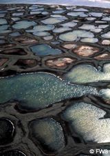
Polygons (pictured to the right) form when soil contraction creates cracks that collect water above the permafrost layer. This water then freezes and expands, forming ice wedges that force the cracks to widen. Years pass and the process repeats, dry winter cold widening cracks, and summer thaws providing water. Joined across the landscape, these cracks create a network of polygons.
Pingos
When a large amount of water is trapped between the soil and the permafrost layer, it freezes and expands upward, pushing up a conical hill called a pingo. Pingos average around 100 feet (30 meters) high.
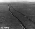
Thermokarst Slumping
Where the insulating layer of plant material has been removed, permafrost melts and the ground above slumps. This is called thermokarst slumping, and it can be a big problem where humans have disturbed the soils.
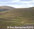
Solifluction
Solifluction is when wet soil slides downhill over the frozen permafrost layer, creating distinctive "wavelike" bulges on hillsides.