Alaska Fish & Wildlife News
March 2011
Anadromous Waters Atlas and Catalog
Where The Salmon Are
Before Alaska became a state, territorial laws were already in place to protect anadromous fish bearing streams. With statehood, various territorial provisions were replaced with state statutes that broadened the protection afforded anadromous species in the state’s rivers, lakes, and streams. Subsequent legislation, passed in 1966, lead to a formal listing of the state’s anadromous rivers, lakes, and streams. With the enactment of Alaska Statute 16.05.870 which required the Alaska Department of Fish and Game (ADF&G) to specify the various rivers, lakes, and streams, or parts of them that are important for spawning, rearing, or migration of anadromous fishes, an official “catalog” was created. Adopted by reference under 5 AAC 95.010 of the Alaska Administrative Code, the "Catalog of Waters Important for Spawning, Rearing, or Migration of Anadromous Fishes," and "An Atlas to Catalog of Waters Important for Spawning, Rearing, or Migration of Anadromous Fishes," (referred to the Catalog and Atlas or collectively as the AWC) were utilized to facilitate this specification. The Catalog provides a listing of water bodies important to the spawning, rearing, or migration of anadromous fish, while the Atlas displays cartographically the location of these specified water bodies, the anadromous fish species found in these waters, and the life history phases for which the waters are utilized.
Due to regulatory changes in 2008, current Alaska Statute (AS 16.05.871) now requires that the ADF&G "specify the various rivers, lakes and streams or parts of them" of the state that are important to the spawning, rearing or migration of anadromous fishes. The Catalog and Atlas are the media still used to accomplish this specification and are presently adopted as regulation under 05 AAC 95.011. The Division of Sport Fish is responsible for information maintained in the ADF&G AWC which is utilized to create the Anadromous Waters Atlas maps and Catalog, while the Division of Habitat is now responsible for initiation of the regulatory process for adoption of maps depicting anadromous streams and catalogs describing stream locations into state regulation.
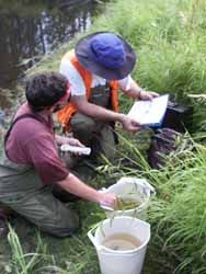
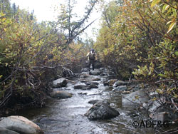
Water bodies listed in the AWC are important because they specify which streams, rivers, and lakes are important to anadromous fish species and therefore afforded protection under AS 16.05.871. Water bodies that are not "specified" within the Catalog and Atlas are not afforded that protection. To be protected under AS 16.05.871, water bodies must be documented as supporting some life function of an anadromous fish species (salmon, trout, char, whitefish, lamprey, smelt, and sturgeon). Anadromous fish must have been seen or collected and identified by a qualified observer. Most nominations come from ADF&G fishery or habitat biologists. Others are received from individuals, natural resource companies, and biologists from other state and federal agencies
ADF&G is responsible for receiving and processing anadromous water body nominations. Changes to the Atlas and Catalog are accomplished through the nomination process. Nominations may be submitted for purposes of (1) adding new water bodies (2) adding species to previously cataloged streams, (3) extending species distribution in cataloged water bodies, (4) deleting water bodies or parts of them, (5) updating survey data on cataloged water bodies, or (6) revising stream channels, labeling errors, or identifying barriers to fish movement.
Nominations should provide adequate information to substantiate the addition or deletion of species or water body, extension of existing habitat, revisions to stream hydrography, correcting annotation errors, or the addition of barriers to the water body. The AWC Project Biologist prepares annotation instructions, which are then reviewed by ADF&G staff prior to inclusion in the AWC and creation of Atlas maps. Once revised maps are drafted and have undergone department, public, and regulatory review they are adopted into regulation.
Presently Atlas maps and Catalog data are available in hard copy form, pdf files, or as shape files that can be imported into mapping software such as ARCMAP. Previously Atlas maps were hand drawn onto mylar sheets, the mylars were then overlaid onto USGS map mylars and blue-line maps were then printed from these composites. Beginning in 1996, the department began transferring hydrography and species data from hard copy to electronic form. One advantage of this work has been the ability to make map data available on-line through an Internet Arc Server website. This allows the user to overlay and view data using topographical or satellite imagery. AWC data can also be viewed in conjunction with resident fish or culvert location data. Another advantage is that data are more easily accessible, which facilitates data requests. Regulatory update of the Atlas and Catalog are scheduled to occur once a year. Additional information, downloadable copies of nomination forms, and a link to the Arc Server website can be found at: http://www.sf.adfg.state.ak.us/SARR/awc/
The Catalog and Atlas, respectively currently contain over 17,000 streams, rivers or lakes around the state. Based upon thorough surveys of a few drainages it is believed that this number represents less than 50% of the streams, rivers and lakes actually used by anadromous species in Alaska.
J. Johnson is Project Biologist for the Anadromous Waters Program.
Subscribe to be notified about new issues
Receive a monthly notice about new issues and articles.