Ice Seal Tracking Maps Archive
07/203/2016 – 08/217/2016

We are pleased to announce that the North Slope Borough Department of Wildlife Management (NSB-DWM) deployed a tag on a subadult female spotted seal on 27 July in Dease Inlet. SS16-01-F was tagged with a transmitter (CTD manufactured by the Seal Mammal Research Unit, University of St. Andrews, UK) we provided to NSB-DWM as part of a collaborative project. This is the third seal to be tagged as part of this collaborative project. Movements made by these seals will be reported on maps prepared by both ADF&G and NSB-DWM.
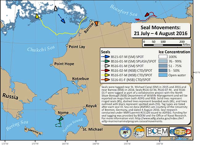
During the last fourteen days we have received locations for 2 bearded seals, 3 ringed seals, and 1 spotted seal. Bearded seal BS15-07-M (blue line) and ringed seals RS16-01-M (gray line) and RS16-07-M (yellow line) are in the northeastern Chukchi Sea near the sea ice edge. Ringed seal RS16-02-M (red line) is in the Beaufort Sea, east of Barrow, along the Alaskan coast. The recently tagged spotted seal, SS16-01-F (orange line), is in Dease Inlet, east of Barrow. Bearded seal BS16-01-M (green line), is south of Nome. No clear satellite images were available from the NASA Rapid Response Network because of thick cloud cover this week. Therefore, I used sea ice data courtesy of the University of Bremen, Germany, and dated 4 August (http://www.iup.uni-bremen.de:8084/amsr2/).
During the last fourteen days we have received locations for 2 bearded seals, 3 ringed seals, and 1 spotted seal. Bearded seal BS15-07-M (blue line) and ringed seals RS16-01-M (gray line) and RS16-07-M (yellow line) are in the northeastern Chukchi Sea near the sea ice edge. Ringed seal RS16-02-M (red line) is in the Beaufort Sea, east of Barrow, along the Alaskan coast. The recently tagged spotted seal, SS16-01-F (orange line), is in Dease Inlet, east of Barrow. Bearded seal BS16-01-M (green line), is south of Nome. No clear satellite images were available from the NASA Rapid Response Network because of thick cloud cover this week. Therefore, I used sea ice data courtesy of the University of Bremen, Germany, and dated 4 August (http://www.iup.uni-bremen.de:8084/amsr2/).
