Information by Fishery
Statistical Area Charts
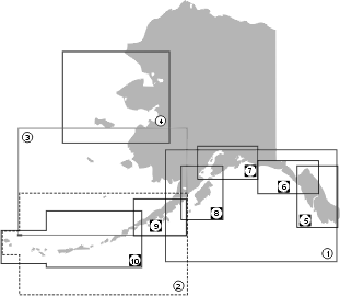
This series of ADF&G groundfish/shellfish statistical area charts became effective in 2009 for groundfish fisheries statewide and for shellfish fisheries excluding Southeast Alaska. These new charts should be used for determining statistical areas for filling out fish tickets from this date forward. Older versions of the charts should be retained for doing historic harvest analysis.
Each of these charts may be downloaded as a PDF file by clicking on any of the designated map area NUMBERS shown in the Index Map on the left (or by using the PDF links below the map).
To download a PDF file, RIGHT-CLICK on the chart link NUMBER in the map itself (or on the specific link below the map) and choose "Save Link As".
Tips
- To print select areas of the large PDF charts it is recommended that PDF files be downloaded to your PC — all viewing and printing can then be done in your standalone Adobe Reader program rather than inside a browser window (utilizing a PDF plugin).
- Get the latest version of Adobe Reader.
- Learn more about the Adobe Acrobat Portable Document Format.
Groundfish and Shellfish Statistical Area Charts Statewide
- 1a) Gulf of Alaska Groundfish/Shellfish (PDF 2,738 kB)
- 1b) Gulf of Alaska Groundfish (PDF 3,088 kB)
- 2) AK Peninsula & Aleutian Islands Groundfish/Shellfish (PDF 10,306 kB)
- 3) Bering Sea Groundfish/Shellfish (PDF 7,702 kB)
- 4) Northern Bering Sea Groundfish/Shellfish (PDF 5,599 kB)
- 5) Southeast AK Groundfish (PDF 10,507 kB)
- 6) Yakutat Groundfish (PDF 10,387 kB)
- 7) Prince William Sound/Cook Inlet Groundfish/Shellfish (PDF 3,590 kB)
- 8) Kodiak Groundfish/Shellfish (PDF 6,535 kB)
- 9) Alaska Peninsula and Chignik Groundfish/Shellfish (PDF 7,241 kB)
- 10) Aleutian Islands Groundfish/Shellfish (PDF 10,367 kB)
- Southeast AK Groundfish Management Areas (PDF 6,989 kB)
- Southeast AK, Baranof Island Groundfish Statistical Areas Detail (PDF 7,593 kB)
- Southeast AK, West Prince of Wales Statistical Areas Detail (PDF 11,265 kB)
Salmon and Shellfish Statistical Area Charts
Southeast Alaska & Yakutat
- Map 4 — Southeast AK King & Tanner Crab (PDF 8,414 kB)
- Map 5 — Southeast AK Salmon/Shellfish (PDF 8,533 kB)
- Map 5a — Juneau Area (PDF 4,859 kB)
- Map 5b — Ketchikan Area (PDF 3,745 kB)
- Map 5c — Petersburg Area (PDF 6,350 kB)
- Map 5d — Sitka Area (PDF 3,332 kB)
- Map 5e — Yakutat Area (PDF 1,325 kB)
Salmon Statistical Area Charts
Central Region
- Bristol Bay Salmon Statistical Area Maps
- Egegik Commercial Salmon Fishery Management District (PDF 779 kB)
- Naknek-Kvichak Commercial Salmon Fishery Management District (PDF 885 kB)
- Nushagak Commercial Salmon Fishery Management District (PDF 252 kB)
- Togiak Commercial Salmon Fishery Management District (PDF 952 kB)
- Ugashik Commercial Salmon Fishery Management District (PDF 788 kB)
- Wood River Special Harvest Area Map (PDF 406 kB)
- Prince William Sound Salmon Statistical Area Maps
- Prince William Sound Statistical Chart (PDF 4,893 kB)
- 212-200 Copper Bering Districts Reporting Areas (PDF 1,418 kB)
- 221 Eastern District Reporting Areas (PDF 1,629 kB)
- 222 Northern District Reporting Areas (PDF 1,789 kB)
- 223 Coghill District Reporting Areas (PDF 1,401 kB)
- 224 Northwestern District Reporting Areas (PDF 1,382 kB)
- 225 Eshamy District Reporting Areas (PDF 1,201 kB)
- 226 Southwestern District Reporting Areas (PDF 2,134 kB)
- 227 Montague District Reporting Areas (PDF 1,454 kB)
- 228 Southeastern District Reporting Areas (PDF 1,255 kB)
- 229 Unakwik District Reporting Areas (PDF 952 kB)
-
Cook Inlet Area District Maps
-
Upper Cook Inlet
- Upper Cook Inlet Salmon Subdistricts (PDF 979 kB)
- Northern District Statistical Areas (PDF 540 kB)
- Central District Set Gillnet Statistical Areas (PDF 921 kB)
- Central District Drfit Gillnet Statistical Areas (PDF 1,150 kB)
- Central District Drfit Gillnet Areas 1_4 (PDF 1,058 kB)
-
Lower Cook Inlet
- Lower Cook Inlet Salmon Subdistricts (PDF 2,316 kB)
-
Upper Cook Inlet
Arctic-Yukon-Kuskokwim Region
- Kuskokwim Commercial Salmon Statistical Area Maps
- Norton Sound Salmon Statistical Area Map (PDF 505 kB)
- Yukon River Statistical Areas
- Yukon River (all districts) (PDF 892 kB)
- Yukon River - District 1 (PDF 557 kB)
- Yukon River - District 1 Setnet (PDF 1,131 kB)
- Yukon River - District 2 (PDF 354 kB)
- Yukon River - District 3 (PDF 472 kB)
- Yukon River - District 4 (PDF 460 kB)
- Anvik River (PDF 270 kB)
- Yukon River - District 5 (PDF 530 kB)
- Yukon River - District 6 (PDF 470 kB)
Westward Region
- Alaska Peninsula Salmon Statistical Area Map (North & South) (PDF 1,397 kB)
- Chignik Salmon Statistical Areas (PDF 34,849 kB)
- Kodiak Salmon Statistical Area Map (PDF 7,480 kB)
![]() Adobe Acrobat PDF files require a free viewer available directly from Adobe.
Adobe Acrobat PDF files require a free viewer available directly from Adobe.