Glacier Mountain Controlled Use Area (GMCUA)
Units: 20E
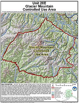
Area Description: The Glacier Mountain Controlled Use Area: the area consists of that portion of Unit 20(E) bounded by a line beginning at Mile 140 of the Taylor Highway, then north along the highway to Eagle, then west along the cat trail from Eagle to Crooked Creek, then from Crooked Creek southwest along the west bank of Mogul Creek to its headwaters on North Peak, then west across North Peak to the headwaters of Independence Creek, then southwest along the west bank of Independence Creek to its confluence with the North Fork of the Fortymile River, then easterly along the south bank of the North Fork of the Fortymile River to its confluence with Champion Creek, then across the North Fork of the Fortymile River to the south bank of Champion Creek and easterly along the south bank of Champion Creek to its confluence with Little Champion Creek, then northeast along the east bank of Little Champion Creek to its headwaters, then northeasterly in a direct line to Mile 140 on the Taylor Highway
Restrictions: The area is closed to the use of any motorized vehicle for hunting, including the transportation of hunters, their hunting gear, or parts of game, from July 26 through September 20; however, this provision does not prohibit motorized access via, or transportation of game on, the Taylor Highway or any airport or the transportation into the area of game meat that has been processed for human consumption.