Bison Range Controlled Use Area
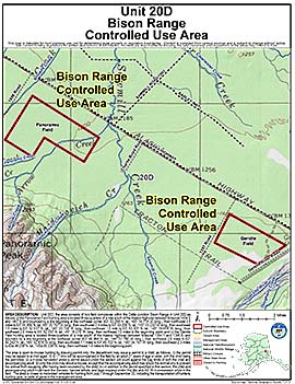
Units: 20D
Area Description: Delta Junction Bison Range in Unit 20(D):
(i) the Panoramic Field hunting area is located three-quarters of a mile south of the Alaska Highway between Milepost 1404.0 and 1407.6, and bounded by a line beginning at the northeast corner (63ø 53.299' N. lat., 145ø 14.714' W. long.), then northwest 3.5 miles to 63ø 54.956' N. lat., 145ø 20.767' W. long., then southwest 2.4 miles to 63ø 53.206' N. lat., 145ø 23.232' W. long., then southeast 1.5 miles to 63ø 52.537' N. lat., 145ø 20.758' W. long., then northeast 1.0 mile to 63ø 53.301' N.lat., 145ø 19.659' W. long., then southeast 2.0 miles to 63ø 52.330' N. lat., 145ø 16.075' W. long., then northeast 1.0 miles to the beginning point; and
(ii) the Gerstle Field hunting area is located three-quarters of a mile south of the Alaska Highway between Milepost 1394.1 and 1396.8, and bounded by a line beginning at the northeast corner (63ø 48.984' N. lat., 144ø 57.766' W. long.), then northwest 2.9 miles to 63ø 50.242' N. lat., 145ø 02.874' W. long., then southwest 1.1 miles to 63ø 49.102' N. lat., 145ø 04. 197' W. long., then southeast 2.3 miles to 63ø 48.239' N. 1at., 145ø 00.339' W. long., then northeast 1.6 miles to the beginning point.
Restrictions: The area is closed to motorized vehicles for hunting from July 1 - September 30, including the transportation of hunters, hunting gear, or parts of game in the area; the area consists of two field hunting areas within the Delta Junction Bison Range in Unit 20(D)