Nushagak River
Other Tools
Other Tools
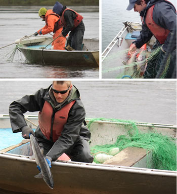
Salmon runs into the Nushagak River are mixed. Say, for example, 70,000 salmon migrate past the site on a peak day. Eighty percent might be sockeye and chum salmon, and 20 percent king salmon. But determining how many sonar-detected fish represent each of these species is difficult. Sonar just detects fish, it cannot identify whether the fish is a sockeye, king or chum salmon. To separate sonar-detected fish by species and produce estimates for each, ADF&G biologists rely on a very important non-sonar tool—inriver gillnets.
Throughout the field season, sonar site crew drift gillnets for two or three periods each day. During each period, the crew drift three nets—each with a different mesh size—several times along each side of the river until they have completed a total of 12 drifts. Fisheries biologists, then examine the proportion of each species in the gillnet catches to determine how many of the sonar-detected fish should be counted as sockeye, king and chum salmon. The crew drift the inriver gillnets just downstream of the sonar transducers so that the catches closely represent the fish passing though the sonar beam. The gillnet crew use buoys marking sonar transducer detection ranges to determine where to drift nets.
Drift Gillnet
[place video here]
Acoustic Tagging
A new type of high-tech fish bell could provide biologists with valuable information about where king salmon swim in the Nushagak River. In 2011 ADF&G launched a three-year project using pinging tags and six underwater microphones—known as hydrophones—to track king salmon migrations in the vicinity of Nushagak River sonar site. As the hydrophones listen for pings transmitted by tagged fish they will record data that can be used to calculate the latitude and longitude of the fish. These coordinates can be calculated for any tagged fish within range of at least three hydrophones. Additionally, each tag will transmit data about water temperature, how deep the fish is and which tagged fish is swimming past.
In initiating the project to better understand king salmon migrations, ADF&G is after two basic pieces of information—what proportion of king salmon migrate beyond the range of the site’s sonar and does that proportion vary from year to year. Because the site’s sonar does not cover the entire river, it only counts a proportion of the kings that migrate past. Small salmon like sockeye swim close to shore where sonar can easily detect them, but larger king salmon often swim in the middle of the river. Consequently, the site’s sonar only counts a proportion of the king salmon migrating past. While a full count is ideal, fisheries biologists can also use a partial count as an index to manage the fishery so long as the site counts the same proportion from year to year. Because the site’s sonar counts within the same region from year to year, biologist have been working under the assumption that it also counts the same proportion of the king salmon from year to year. The king salmon migration project is designed to test this assumption.
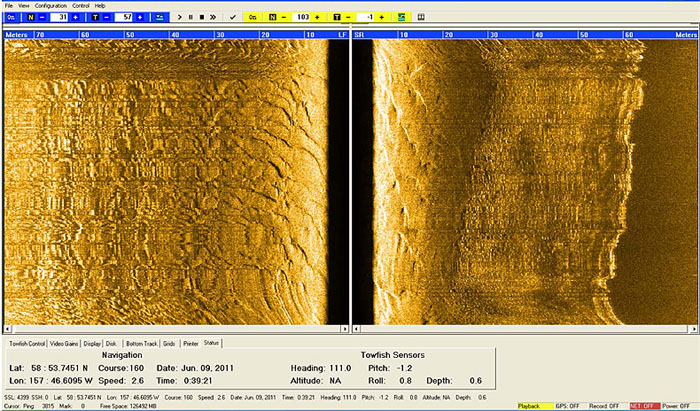
As part of the project, acoustics specialists have used two types of boat-mounted sonar to create bathymetry and water velocity maps of the river channel in which the hydrophones are tracking tagged king salmon. The maps will help biologist better understand king salmon migrations through the channel because fish often orientate their swimming patterns according to river bottom features and variations in water velocity. They might, for example, use a submerged sand bar to cross from one side of the river to the other or to swim further off shore. And as a general rule, migrating fish swim in areas where they face slower velocity, such as along the river bottom. Fisheries biologists working on the project are also using a type of boat-mounted sonar known as side-scan sonar to produce almost photo-like images of the river bottom sediments and grasses, that can also capture images of fish migrating past.
Until the project is completed in 2013, ADF&G biologists are asking fishermen who catch tagged king salmon downstream of the sonar site to please release them back into the river unharmed. Tagged fish will have acoustic tags in their stomachs, but can be identified by colored spaghetti tags attached under the dorsal fin.