Westward Region Research
Overview
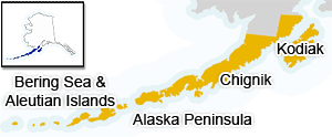
Westward Region includes the Kodiak archipelago, the north and south sides of the Alaska Peninsula (including Chignik, the Shumagin Islands, and Port Moller), and the Aleutian Islands. Dutch Harbor, the number one fishing port in the nation, in pounds landed, is situated in the Aleutian Islands. This region encompasses all Pacific Ocean waters extending south from the Kodiak Archipelago and west of the longitude of the eastern side of Cook Inlet, as well as Bering Sea waters east of the maritime boundary between Russia and the United States. The islands of St. Matthew and the Pribilofs, as well as the Chukchi-Beaufort seas, also fall within the Westward Region. Westward Region supports a diverse mix of shellfish and finfish fisheries, including the largest crab and Pacific cod fisheries in the state. Important salmon and herring fisheries occur throughout the coastal waters of the region. Management is particularly complex because of interaction and coordination between respective federal and state fishery management plans and jurisdictions; for example, coordination with the federal government for state-waters Pacific cod fisheries. Joint state and federal fishery management programs have been implemented regarding management of Bering Sea-Aleutian Islands crab and regional scallop fisheries.