Controlled Use Areas
Note: Use of these maps indicates that you have read and understand the liability statement.
Click on an area name for additional details, or use the dropdown box below.
| Name | GMU | Restrictions | View Map |
|---|---|---|---|
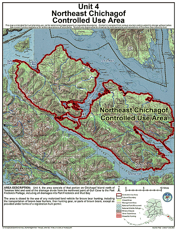
| Northeast Chichagof Controlled Use Area | 04 | Closed to the use of any motorized land vehicle for brown bear hunting, including the transportation of brown bear hunters, their hunting gear, or parts of brown bears, except as provided under terms of a registration hunt permit |
GIF Map
(142 K)
PDF Map (579 K) |
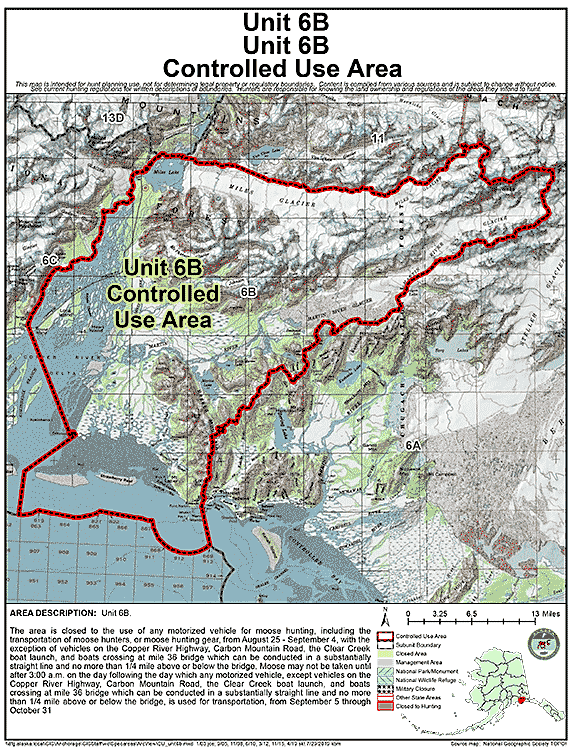
| Unit 6(B) Controlled Use Area | 06B | The area is closed to the use of any motorized vehicle for moose hunting, including the transportation of moose hunters, or moose hunting gear, from August 25 - September 4, with the exception of vehicles on the Copper River Highway, Carbon Mountain Road, the Clear Creek boat launch, and boats crossing at mile 36 bridge which can be conducted in a substantially straight line and no more than 1/4 mile above or below the bridge. Moose may not be taken until after 3:00 a.m. on the day following the day which any motorized vehicle, except vehicles on the Copper River Highway, Carbon Mountain Road, the Clear Creek boat launch, and boats crossing at mile 36 bridge which can be conducted in a substantially straight line and no more than 1/4 mile above or below the bridge, is used for transportation, from September 5 through October 31 |
GIF Map
(144 K)
PDF Map (358 K) |
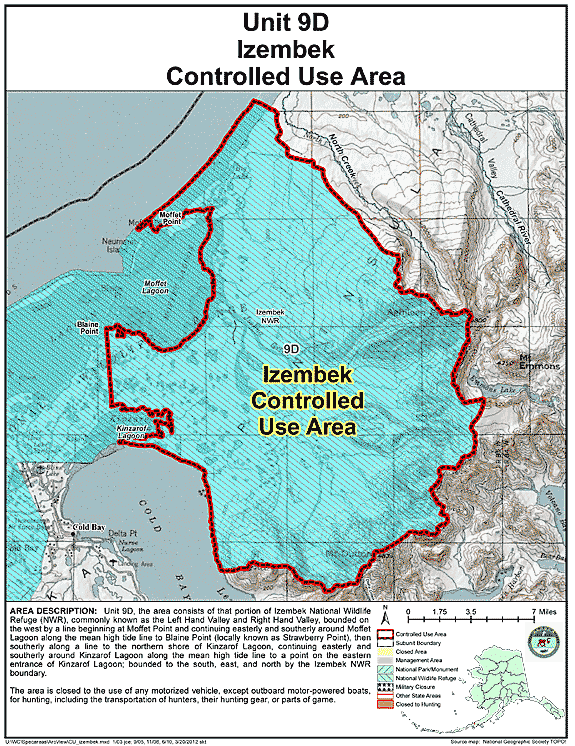
| Izembek Controlled Use Area | 09 | Closed to the use of any motorized vehicle, except outboard motor-powered boats, for hunting, including the transportation of hunters, their hunting gear, or parts of game |
GIF Map
(124 K)
PDF Map (510 K) |
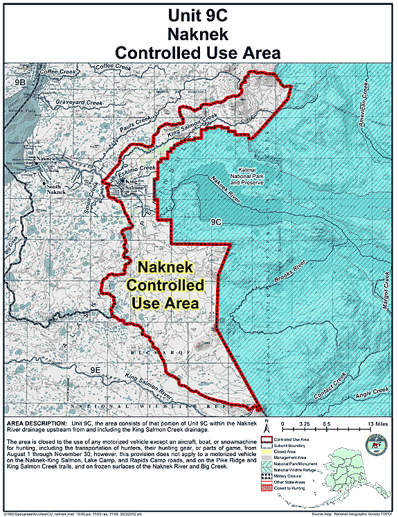
| Naknek Controlled Use Area | 09C | Closed to the use of any motorized vehicle except an aircraft, boat, or snowmachine for hunting, including the transportation of hunters, their hunting gear, or parts of game, from August 1 through November 30; however, this provision does not apply to a motorized vehicle on the Naknek-King Salmon, Lake Camp, and Rapids Camp roads, and on the Pike Ridge and King Salmon Creek trails, and on frozen surfaces of the Naknek River and Big Creek |
GIF Map
(136 K)
PDF Map (487 K) |
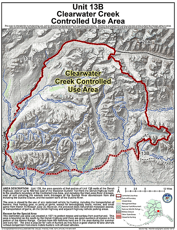
| Clearwater Creek Controlled Use Area | 13B | Closed to the use of any motorized vehicle for hunting, including the transportation of hunters, their hunting gear, or parts of game, except for brown/grizzly bears, wolves, and small game from March 15 through June 30; however, this provision does not prohibit motorized access, or transportation of game, on the Denali Highway and adjacent highway vehicle parking areas |
GIF Map
(154 K)
PDF Map (455 K) |
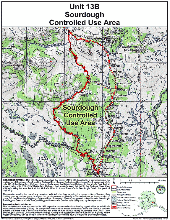
| Sourdough Controlled Use Area | 13B | Closed to the use of any motorized vehicle for hunting, including the transportation of hunters, their hunting gear, or parts of game; however, this provision does not prohibit motorized access, or transportation of game, on the Richardson Highway, Gulkana River, Sourdough Creek Campground or boat launch, Sourdough and Haggard Creeks, Middle Fork and Haggard Creek trails, or other trails designated by the department |
GIF Map
(146 K)
PDF Map (429 K) |
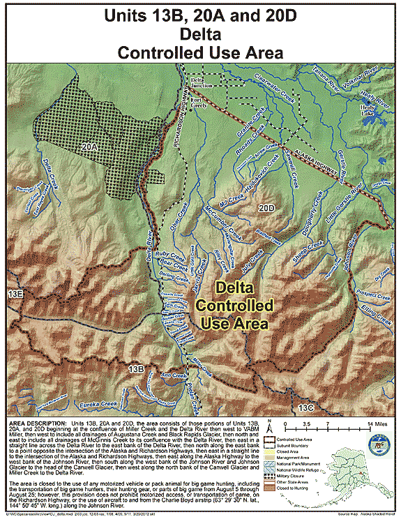
| Delta Controlled Use Area | 13B, 20A, 20D | Closed to the use of any motorized vehicle or pack animal for big game hunting, including the transportation of big game hunters, their hunting gear, or parts of big game from August 5 through August 25; however, this provision does not prohibit motorized access, or transportation of game, on the Richardson Highway, or the use of aircraft to and from the Charlie Boyd airstrip (63° 29' 30N. lat., 144° 50' 45"W. long.) along the Johnson River |
GIF Map
(145 K)
PDF Map (487 K) |
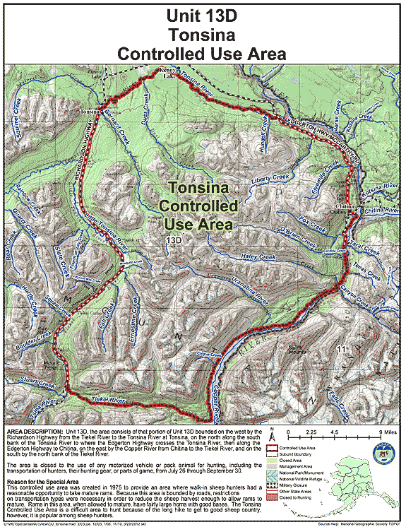
| Tonsina Controlled Use Area | 13D | Closed to the use of any motorized vehicle or pack animal for hunting, including the transportation of hunters, their hunting gear, or parts of game, from July 26 through September 30 |
GIF Map
(154 K)
PDF Map (571 K) |
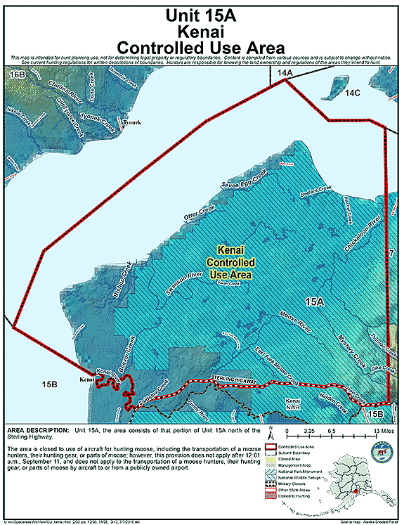
| Kenai Controlled Use Area | 15A | Closed to use of aircraft for hunting moose, including the transportation of a moose hunters, their hunting gear, or parts of moose; however, this provision does not apply after 12:01 a.m., September 11, and does not apply to the transportation of a moose hunters, their hunting gear, or parts of moose by aircraft to or from a publicly owned airport |
GIF Map
(90 K)
PDF Map (437 K) |
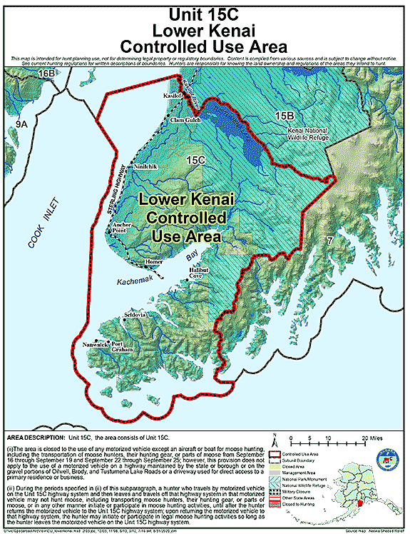
| Lower Kenai Controlled Use Area | 15C | A. The area is closed to the use of any motorized vehicle except an aircraft or boat for moose hunting, including the transportation of moose hunters, their hunting gear, or parts of moose from September 16 through September 19 and September 22 through September 25; however, this provision does not apply to the use of a motorized vehicle on a highway maintained by the state or borough or on the gravel portions of Oilwell, Brody, and Tustumena Lake Roads or a driveway used for direct access to a primary residence or business B. During the periods specified in (ii) of this subparagraph, a hunter who travels by motorized vehicle on the Unit 15(C) highway system and then leaves and travels off that highway system in that motorized vehicle may not hunt moose, including transporting moose hunters, their hunting gear, or parts of moose, or in any other manner initiate or participate in moose hunting activities, until after the hunter returns the motorized vehicle to the Unit 15(C) highway system; upon returning the motorized vehicle to that highway system, the hunter may initiate or participate in legal moose hunting activities so long as the hunter leaves the motorized vehicle on the Unit 15(C) highway system; |
GIF Map
(98 K)
PDF Map (447 K) |
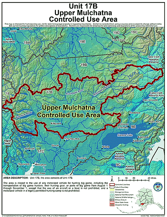
| Upper Mulchatna Controlled Use Area | 17B | Closed to the use of any motorized vehicle for hunting big game, including the transportation of big game hunters, their hunting gear, or parts of big game from August 1 through November 1, except that the use of an aircraft or a boat is not prohibited, and a motorized vehicle in a legally permitted hunting camp is not prohibited |
GIF Map
(136 K)
PDF Map (1,275 K) |
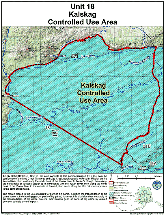
| Kalskag Controlled Use Area | 18 | Closed to the use of aircraft for hunting big game, including the transportation of big game hunters, their hunting gear, or parts of big game; however, this provision does not apply to the transportation of big game hunters, their hunting gear, or parts of big game by aircraft between publicly owned airports |
GIF Map
(130 K)
PDF Map (475 K) |
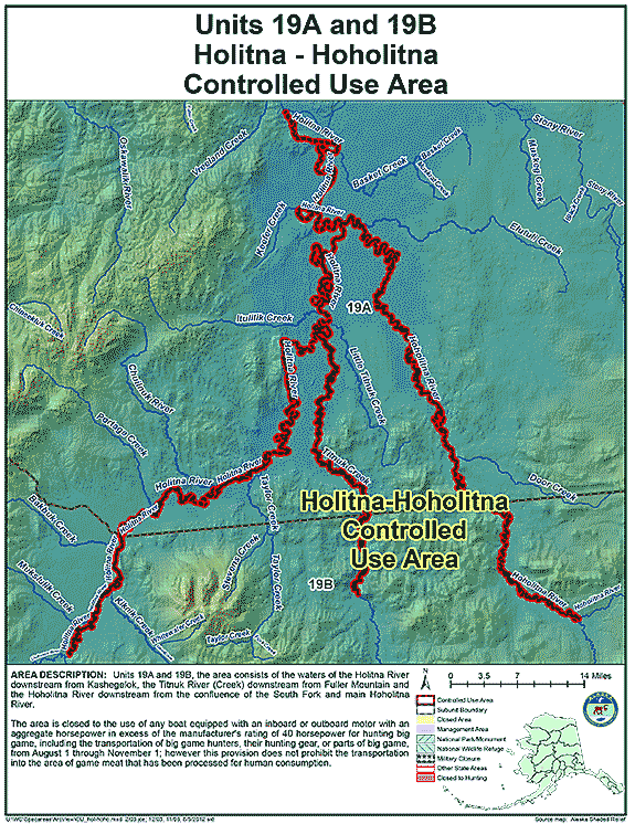
| Holitna-Hoholitna Controlled Use Area | 19 | The area is closed to the use of any boat equipped with an inboard or outboard motor with an aggregate horsepower in excess of the manufacturer's rating of 40 horsepower for hunting big game, including the transportation of big game hunters, their hunting gear, or parts of big game from August 1 through November 1. However, this provision does not apply to the transportation into the area of game meat that has been processed for human consumption. |
GIF Map
(107 K)
PDF Map (460 K) |
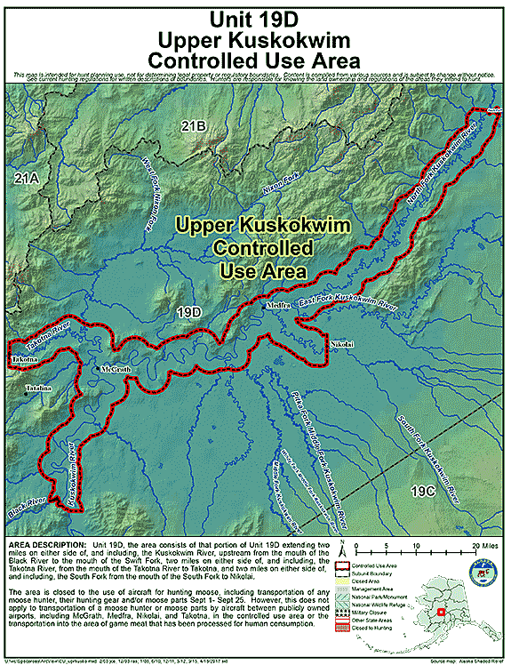
| Upper Kuskokwim Controlled Use Area (UKCUA) | 19D | The area is closed to the use of aircraft for hunting moose, including the transportation of moose hunters, their hunting gear, or parts of moose from September 1 through September 25; however, this provision does not apply to the transportation of moose hunters, their hunting gear, or parts of moose by aircraft between publicly owned airports, including McGrath, Medfra, Nikolai, and Takotna, or the transportation into the area of game meat that has been processed for human consumption. |
GIF Map
(123 K)
PDF Map (462 K) |
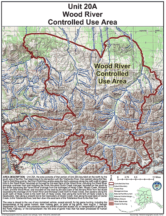
| Wood River Controlled Use Area | 20A | The area is closed to the use of any motorized vehicle except aircraft for big game hunting, including the transportation of big game hunters, their hunting gear, or parts of big game, from August 1 through September 30; however, this provision does not prohibit motorized access via, or transportation of game on, the Parks Highway; or the transportation into the area of game meat that has been processed for human consumption. |
GIF Map
(167 K)
PDF Map (672 K) |
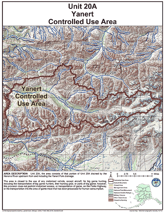
| Yanert Controlled Use Area | 20A | The area is closed to the use of any motorized vehicle, except aircraft, for big game hunting, including the transportation of big game hunters, their hunting gear, or parts of big game; however, this provision does not prohibit motorized access, or transportation of game, on the Parks Highway, or the transportation into the area of game meat that has been processed for human consumption. |
GIF Map
(165 K)
PDF Map (674 K) |
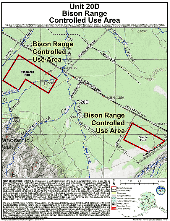
| Bison Range Controlled Use Area | 20D | The area is closed to motorized vehicles for hunting from July 1 - September 30, including the transportation of hunters, hunting gear, or parts of game in the area; the area consists of two field hunting areas within the Delta Junction Bison Range in Unit 20(D) |
GIF Map
(120 K)
PDF Map (228 K) |
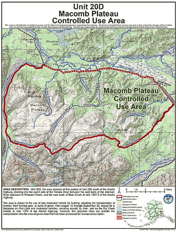
| Macomb Plateau Controlled Use Area | 20D | The area is closed to the use of any motorized vehicle for hunting, including the transportation of hunters, their hunting gear, or parts of game, from August 10 through September 30, except for a floatplane on Fish Lake and motorized vehicles, including aircraft, to, from, and on the Dry Creek Airstrip at mile 1379 of the Alaska Highway; however, this provision does not apply to the transportation into the area of game meat that has been processed for human consumption. |
GIF Map
(156 K)
PDF Map (548 K) |
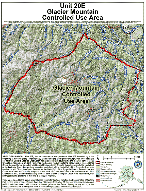
| Glacier Mountain Controlled Use Area (GMCUA) | 20E | The area is closed to the use of any motorized vehicle for hunting, including the transportation of hunters, their hunting gear, or parts of game, from July 26 through September 20; however, this provision does not prohibit motorized access via, or transportation of game on, the Taylor Highway or any airport or the transportation into the area of game meat that has been processed for human consumption. |
GIF Map
(173 K)
PDF Map (630 K) |
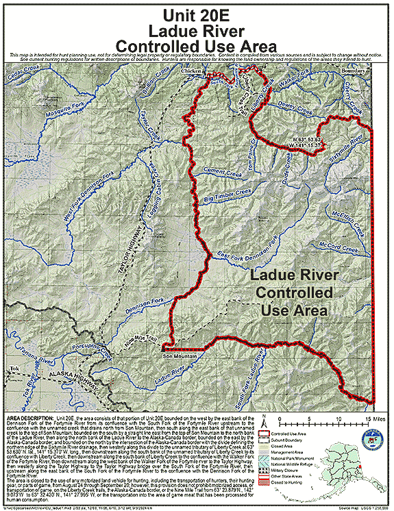
| Ladue River Controlled Use Area | 20E | The area is closed to the use of any motorized land vehicle for hunting, including the transportation of hunters, their hunting gear, or parts of game, from August 24 through September 20; however, this does not prohibit motorized access, or transportation of game, on the Nine Mile and Liberty Creek trails, the Alaska-Canada border, or the Boundary Cutoff of the Taylor Highway, or the transportation into the area of game meat that has been processed for human consumption; the Nine Mile Trail as referenced in this regulation refers to the single primary ATV trail beginning along the Taylor Highway at 63° 24.233' N. lat., 142° 28.422' W. long., entering the western portion of the defined controlled use area at 63° 23.879' N. lat., 142° 09.073' W. long., and terminating at 63° 32.420' N. lat., 141° 27.995' W. long., only the single primary trail including connected bypasses no more than 20 feet. |
GIF Map
(252 K)
PDF Map (2,138 K) |
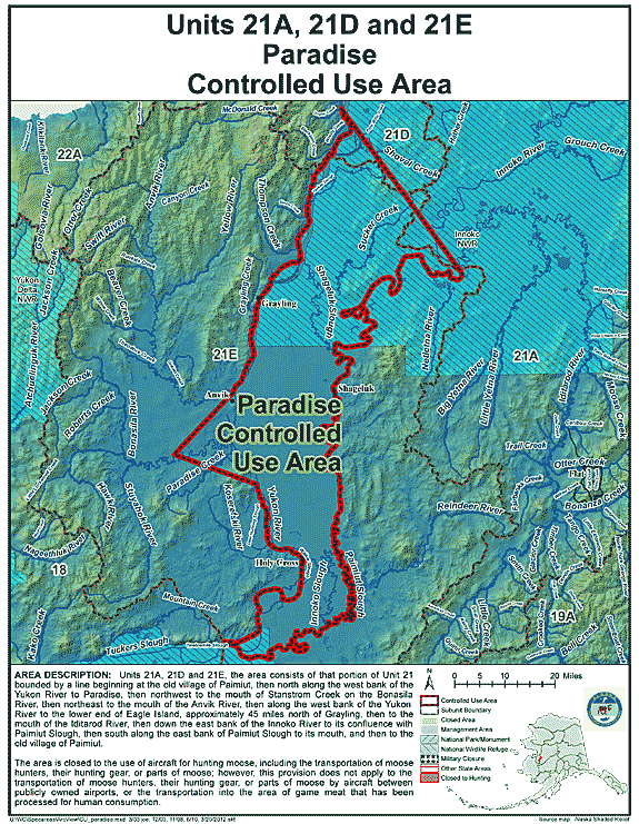
| Paradise Controlled Use Area | 21 | The area is closed to the use of aircraft for hunting moose, including the transportation of moose hunters, their hunting gear, or parts of moose; however, this provision does not apply to the transportation of moose hunters, their hunting gear, or parts of moose by aircraft between publicly owned airports, or the transportation into the area of game meat that has been processed for human consumption. |
GIF Map
(142 K)
PDF Map (705 K) |
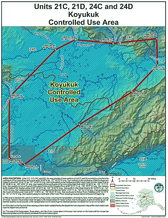
| Koyukuk Controlled Use Area | 21, 24 | The area is closed to the use of aircraft for hunting moose, including the transportation of moose hunters, their hunting gear, or parts of moose; however, this provision does not apply to the transportation of moose hunters, their hunting gear, or parts of moose by aircraft between publicly owned airports, or the transportation into the area of game meat that has been processed for human consumption. All hunters on the Koyukuk River passing a check station established by the department are required to stop at the check station and report to department personnel. The meat of the hindquarters, forequarters, and ribs of any moose taken in the area must remain on the bone until the moose has been transported out of the area. |
GIF Map
(146 K)
PDF Map (596 K) |
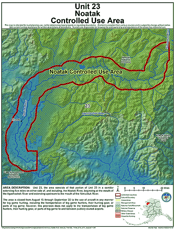
| Noatak Controlled Use Area | 23 | The area is closed from Aug. 15 - Sept. 30 to the use of aircraft in any manner for big game hunting, including transportation of big game hunters, their hunting gear, and/or parts of big game; however, this does not apply to the transportation of big game hunters or parts of big game to and between publicly owned airports. |
GIF Map
(128 K)
PDF Map (537 K) |
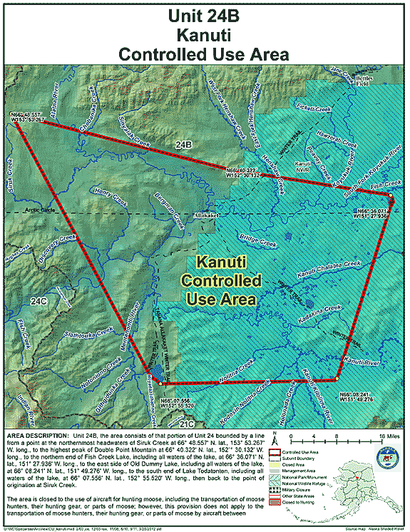
| Kanuti Controlled Use Area | 24 | The area is closed to the use of aircraft for hunting moose, including transportation of moose hunters, their gear, and/or parts of moose. However, this prohibition does not apply to the transportation into the area of game meat that has been processed for human consumption. |
GIF Map
(138 K)
PDF Map (492 K) |
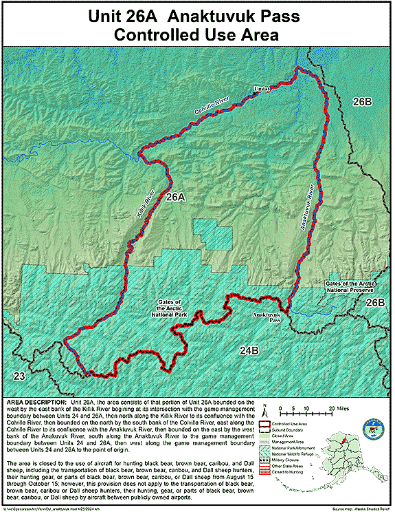
| Anaktuvuk Pass Controlled Use Area | 26 | The area is closed to the use of aircraft for hunting caribou, including the transportation of caribou hunters, their hunting gear, or parts of caribou from August 15 through October 15; however, this provision does not apply to the transportation of caribou hunters, their hunting gear, or parts of caribou by aircraft between publicly owned airports. |
GIF Map
(122 K)
PDF Map (486 K) |
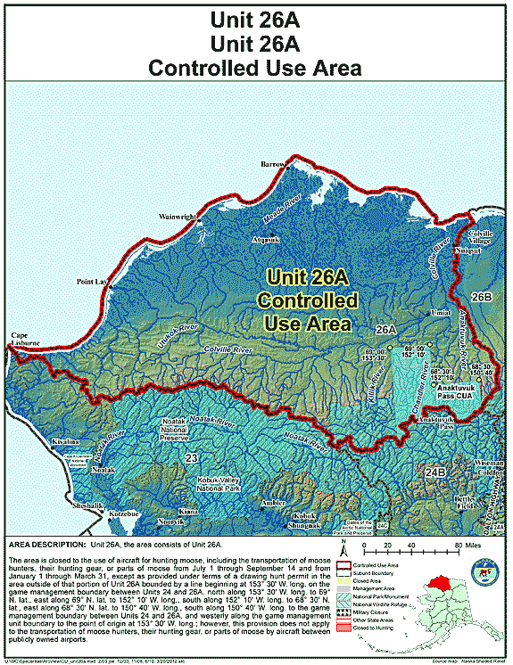
| Unit 26(A) Controlled Use Area | 26A | The area is closed to the use of aircraft for hunting moose, including the transportation of moose hunters, their hunting gear, or parts of moose from July 1 through September 14 and from January 1 through March 31, except as provided under terms of a drawing hunt permit in the area outside of that portion of Unit 26(A) bounded by a line beginning at 153° 30' W. long. on the game management boundary between Units 24 and 26(A), north along 153° 30' W. long. to 69° N. lat., east along 69° N. lat. to 152° 10' W. long., south along 152° 10' W. long. to 68° 30' N. lat., east along 68° 30' N. lat. to 150° 40' W. long., south along 150° 40' W. long. to the game management boundary between Units 24 and 26(A), and westerly along the game management unit boundary to the point of origin at 153° 30' W. long.; however, this provision does not apply to the transportation of moose hunters, their hunting gear, or parts of moose by aircraft between publicly owned airports. |
GIF Map
(111 K)
PDF Map (373 K) |