
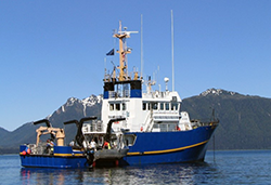
Commercial Dive Fisheries
Southeast Alaska & Yakutat
The Southeast Alaska/Yakutat dive fisheries include sea cucumbers, red sea urchins, and geoducks. These fisheries are managed by area office management biologists and stock assessment and research is done by the dive fisheries research group. Commercial fisheries for most of these fisheries are opened and assessed on a rotational calendar, where stocks may be surveyed or opened to commercial fishing every second, third, or more years, depending on the species. Additional information about the dive fisheries can be found on our Commercial Dive Fisheries webpage.
The Southeast Alaska Regional Dive Fisheries Association (SARDFA) is a commercial stakeholder organization that provides the department with partial stock assessment funding and has three committees (Sea Cucumber, Geoduck, and Sea Urchin) that provide input to the department on matters concerning fishery management.
Recorded Announcements: For recorded fishery information in Southeast Alaska
please see the Southeast Contacts page.
Fishery Advisory Announcements
- Southeast Alaska Commercial Geoduck Fishery Announcement (PDF 255 kB) - 5/15/26
- Southeast Alaska Commercial Geoduck Fishery Announcement (PDF 255 kB) - 5/11/26
- Southeast Alaska Commercial Geoduck Fishery Announcement (PDF 260 kB) - 5/5/26
- 2025/26 Southeast Alaska Sea Cucumber Fishery Summary (PDF 271 kB) - 4/30/26
- Southeast Alaska Commercial Geoduck Fishery Announcement (PDF 261 kB) - 4/27/26
- Southeast Alaska Commercial Geoduck Fishery Announcement (PDF 260 kB) - 4/20/26
- Southeast Alaska Commercial Geoduck Fishery Announcement (PDF 259 kB) - 4/13/26
- 2025/26 Southeast Alaska Commercial Sea Cucumber Fishery Announcement (PDF 273 kB) - 4/9/26
- Southeast Alaska Commercial Geoduck Fishery Announcement (PDF 255 kB) - 4/6/26
- 2025/26 Southeast Alaska Commercial Sea Cucumber Fishery Announcement (PDF 274 kB) - 4/2/26
- Southeast Alaska Commercial Geoduck Fishery Announcement (PDF 258 kB) - 3/27/26
- 2025/26 Southeast Alaska Commercial Sea Cucumber Fishery Announcement (PDF 274 kB) - 3/26/26
- Southeast Alaska Commercial Geoduck Fishery Announcement (PDF 258 kB) - 3/24/26
- 2025/26 Southeast Alaska Commercial Sea Cucumber Fishery Announcement (PDF 273 kB) - 3/19/26
- Southeast Alaska Commercial Geoduck Fishery Announcement (PDF 261 kB) - 3/16/26
- 2025/26 Southeast Alaska Commercial Sea Cucumber Fishery Announcement (PDF 273 kB) - 3/12/26
- Southeast Alaska Commercial Geoduck Fishery Announcement (PDF 261 kB) - 3/9/26
- Southeast Alaska Commercial Geoduck Fishery Announcement (PDF 261 kB) - 3/2/26
- Southeast Alaska Commercial Geoduck Fishery Announcement (PDF 262 kB) - 2/23/26
- Southeast Alaska Commercial Geoduck Fishery Announcement (PDF 212 kB) - 2/17/26
- Southeast Alaska Commercial Geoduck Fishery Announcement (PDF 220 kB) - 2/9/26
- Southeast Alaska Commercial Geoduck Fishery Announcement (PDF 219 kB) - 2/2/26
- 2025/26 Southeast Alaska Commercial Sea Cucumber Fishery Announcement (PDF 231 kB) - 1/29/26
- Southeast Alaska Commercial Geoduck Fishery Announcement (PDF 214 kB) - 1/27/26
- Southeast Alaska Commercial Geoduck Fishery Announcement (PDF 219 kB) - 1/26/26
- 2025/26 Southeast Alaska Commercial Sea Cucumber Fishery Announcement (PDF 230 kB) - 1/22/26
- Southeast Alaska Commercial Geoduck Fishery Announcement (PDF 219 kB) - 1/20/26
- 2025/26 Southeast Alaska Commercial Sea Cucumber Fishery Announcement (PDF 230 kB) - 1/15/26
- Southeast Alaska Commercial Geoduck Fishery Announcement (PDF 218 kB) - 1/13/26
- 2025/26 Southeast Alaska Commercial Sea Cucumber Fishery Announcement (PDF 230 kB) - 1/8/26
- Southeast Alaska Commercial Geoduck Fishery Announcement (PDF 218 kB) - 1/5/26
Harvest
Management
Maps
Geoduck
- Geoduck Fishery Area Map and Rotation List (PDF 734 kB)
- Geoduck Fishery Area Map and Rotation List, West Side of Price of Wales Island (PDF 709 kB)
Sea Urchin
- Urchin Fishery Area Map (PDF 1,436 kB)
Sea Cucumber
- Sea Cucumber Fishery Area Rotation Overview (PDF 674 kB)
- Sea Cucumber Fishery Area Rotation — Northern Southeast (PDF 588 kB)
- Sea Cucumber Fishery Area Rotation — Southern Southeast (PDF 684 kB)
Dive Fisheries Research in Southeast Alaska & Yakutat
General
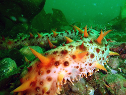
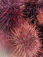
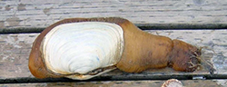
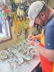
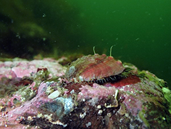
In Southeast Alaska, the "dive fisheries" species include California sea cucumbers (Apostichopus californicus), geoducks (Panopea generosa), red sea urchins (Mesocentrotus franciscanus), and pinto abalone (Haliotis kamschatkana). These species occur along the west coast of North America, from Baja California to Alaska. They are benthic invertebrates that live in nearshore marine waters. Sea cucumbers are found throughout all waters of Southeast Alaska and in Yakutat Bay. Geoducks, red sea urchins, and abalone are found primarily in southern Southeast Alaska and outer coastal areas from Dixon Entrance to Sitka Sound.
Sea cucumbers, geoducks, and red sea urchins are targeted by fisheries in Southeast Alaska, which are conducted using dive equipment such as SCUBA or surface-supplied air systems called "hookah". Although in the past a commercial fishery was open for pinto abalone, it closed indefinitely starting in 1996 due to low abundance. Management of the dive fisheries is based on an assessment of biomass levels within each of the numerous fishery management units throughout Southeast Alaska. These areas are opened to commercial harvest on a rotational basis, where they may be surveyed and opened to commercial fishing every second, third, or more years, depending on the species. Stock assessment programs have been in place to support dive fishery management in Southeast Alaska since the early stages of development of the sea cucumber, geoduck, and red sea urchin fisheries.
The basic design of stock assessment surveys is very similar among target species. All stock assessments require an estimate of the survey area size, density, and mean individual weight for a stock within a given fishery area; these values are then multiplied together to produce a biomass estimate. Density is estimated using either an area-based design (for geoducks and some red urchin areas) or a shoreline-based design (for sea cucumbers and most red urchin areas). An area-based design is used when the spatial extent of seafloor within the target depth zone of a given fishery area, or the area of a geoduck bed, is known. Density can then be estimated within this area as the number of individuals per square meter. If the area cannot be estimated with a reasonable degree of accuracy, a shoreline-based design is used. In this case, density is calculated by the number of individuals per meter of shoreline.
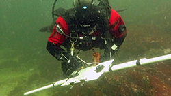
Dive surveys are conducted during late spring through summer. For all species, SCUBA divers conduct paired transects, which are used to estimate the density of the target species. The width of each transect depends on the species surveyed. One-meter transects are used for geoduck and red sea urchin surveys, whereas two-meter transects are used for sea cucumbers due to their larger size and lower densities.
Projects
Sea cucumbers surveys
Sea cucumber surveys are conducted in each management unit that is scheduled to open in the commercial fishery during the upcoming fall. Each area is surveyed and opened to the fishery once every three years. To survey sea cucumbers, dive teams survey to a target depth of 50 feet (mean lower low water or MLLW), which is the depth corrected for the tidal height immediately prior to the survey dive. For example, a +5 ft tide results in a target dive depth of 55 ft. Divers survey transects using 2-meter-wide PVC transect rods and datasheets.
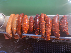
Along the seafloor, the two divers swim parallel to each other on a predetermined compass bearing while each holds a transect rod. While surveying, the transect rod is held level with the seafloor, and perpendicular to the transect bearing. All observed sea cucumbers >10cm are counted and recorded. Since the area of the transect is not measured, the result is an estimate of the numbers of sea cucumbers per meter of shoreline. In addition to counting sea cucumbers, 15 sea cucumbers are collected along the transect and brought to the surface for later measurement of weights.
In addition to surveying commercial harvest areas, each year ADF&G divers also survey several "control areas", which are closed to commercial fisheries. These areas provide important data to compare unexploited sea cucumber populations to those subject to harvest, which helps to evaluate the effectiveness and sustainability of fisheries management.
The results of the sea cucumber dive surveys are used to estimate biomass and to set guideline harvest levels (GHLs) for the next commercial fishery opening in October. The harvest rate of sea cucumbers is set at 7.7% per year, which is tripled to account for the triennial fishery.
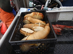
Geoduck surveys
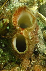
Geoducks are the largest burrowing clam in the world and one of the longest living animals with lifespans up to at least 140 years. Stock assessment surveys for geoducks have been conducted in Southeast Alaska for over 35 years. Surveys were first conducted in 1982 at Noyes Island, west of Prince of Wales Island. Beginning in 1997, surveys were conducted regularly in other existing commercial harvest areas, and in several new fishery areas.
Geoducks are surveyed using similar methods as sea cucumbers; however, geoduck survey design differs from that of sea cucumber in a few ways. Each area is surveyed at least once every 12 years and density is assessed using an area-based design for transects. Surveys are typically conducted during May or June because it is assumed that geoducks are more likely to be feeding during these months, and thus more easily identified and enumerated. Each transect is surveyed in 10-meter intervals to measure area and obtain density estimates along the transect. Transects are surveyed to a maximum depth of 60 ft MLLW by correcting for tide. This depth zone includes most of the depth range in which commercial divers normally operate, although commercial geoduck beds and harvesting do occur deeper. Geoduck densities calculated from surveys are adjusted using a show factor to account for unseen geoducks below the surface of the substrate at the time of the survey. A show factor is an estimate of the proportion of observed to actual geoducks present and is based on a study over several days to examine the number of geoducks that surface from the substrate after initial counting.
To estimate age and size compositions, geoducks are sampled by removing them from the sediment and sending them to the laboratory for analysis. Individual weights are measured to estimate average weight for calculating total biomass. Geoduck shells are used to estimate age by removing and polishing a thin cross-section of the umbo (i.e., clam hinge), which contains annual growth lines that are counted. Estimating age is important for tracking recruitment events and is important for setting appropriate fishery harvest rates. Because geoducks are long-lived and have low, sporadic recruitment, the harvest rate is set low, at 2% annually.
Red sea urchin surveys
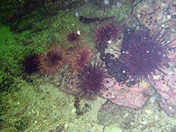
Like sea cucumbers and geoducks, surveys for red sea urchins are required by regulation before fisheries may be opened. Red urchin fishery areas are usually surveyed every three years, although a provision allows every six years if commercial harvest is very low. Surveys are usually performed during the spring or summer immediately preceding the October season start.
Urchin surveys are very similar to sea cucumber surveys in that they count individuals along a transect without area measurements, producing results of urchins per meter of shoreline. Differences include using paired 1-meter-wide transect rods and sampling to three target MLLW depths: 33 ft, 40 ft, and 50 ft.
To estimate size, 30 red sea urchins are sampled near each transect and brought to the surface for measurement of test diameters. After measuring, urchins are returned to the water. The diameter of urchin tests are later converted into weight using a relationship defined by a study that measured both test diameter and weight. Mean weight is used in combination with urchin counts to estimate biomass in survey areas and ultimately set guideline harvest levels (GHLs). A 6% annual harvest rate is applied to biomass estimates to determine GHLs, which are tripled to account for a triennial fishery.
Abalone research
Pinto abalone is the species that were first subject to commercial dive fisheries in Southeast Alaska, with landings starting in the mid-1960s. After a boom-and-bust commercial fishery that peaked in the late 1970s, the fishery closed following the 1995 season and has not reopened since, due to continued low abundance. Although some research projects were conducted during the years of the fishery, a comprehensive stock assessment survey was never implemented to track population levels.
In more recent years, ADF&G has been involved in research intended to better understand the population status of pinto abalone in Southeast Alaska. Following a 2013 petition to list pinto abalone as Endangered under the U.S. Endangered Species Act (ESA), and after recommendation from the ESA status review team, ADF&G collaborated with the National Oceanic and Atmospheric Administration, National Marine Fisheries Service to design and conduct small-scale surveys in Southeast Alaska. This work produced survey methods and established study sites, but due to the short-term nature of the funding, it was not continued beyond a couple of years by ADF&G. Current abalone research by ADF&G is limited to a small-scale survey in the Ketchikan/Gravina Island area to monitor abalone abundance, density, and size.
In 2015, ADF&G collaborated with the Sitka Sound Science Center, the University of Alaska Southeast, and the US Coast Guard Academy to initiate pinto abalone surveys in Sitka Sound, funded in part by Alaska Seagrant, and summarized in the following video clip funded by Alaska Seagrant and produced by Pioneer Studies of Denver, CO.
Kelp and Abalone: Sentinels for Climate Change from Sitka Sound Science Center on Vimeo.
Publications authored by ADF&G Staff describing stock assessment and research
- Operational Plan: Dive Fisheries Stock Assessment Surveys in Southeast Alaska (PDF 2,129 kB)
- Status of Sea Cucumber Stocks in Southeast Alaska and Evaluation of the Stock Assessment Program (PDF 1,857 kB)
- Southeast Alaska Sea Cucumber Stock Assessment Surveys in 2009 (PDF 1,864 kB)
- Southeast Alaska Sea Cucumber Stock Assessment Surveys in 2010 (PDF 3,790 kB)
- Southeast Alaska Sea Cucumber Stock Assessment Surveys in 2011 (PDF 3,135 kB)
- Red Sea Urchin Assessment Surveys Districs 101, 103, and 104, 1999 (PDF 528 kB)
- Red Sea Urchin Assessment Surveys Districs 101, 103, and 104, 2000 (PDF 704 kB)
- Red Sea Urchin Assessment Surveys Districs 101, 103, and 104, 2001 (PDF 1,024 kB)
- Southeast Alaska 2009 Geoduck Stock Assessment (PDF 5,475 kB)
- Pinto abalone surveys in southern Southeast Alaska 2016 (PDF 9,526 kB)
- Green Sea Urchin (Strongylocentrotus droebachiensis) Reconnaissance and Stock Assessment Surveys in Southeast Alaska in 2000–2001 (PDF 4,833 kB)
![]() Adobe Acrobat PDF files require a free viewer available directly from Adobe.
Adobe Acrobat PDF files require a free viewer available directly from Adobe.