Living with Wildlife in Anchorage:
A Cooperative Planning Effort
Chapter 6: Priority Actions (Part 1)
Habitat and Species Conservation Actions
As human population and development increase in Anchorage, wildlife habitat is often lost or changed. The following eight priority actions have been identified to address the need to protect, enhance, or restore the remaining quality wildlife habitat in Anchorage, and are discussed in greater detail in subsequent pages. The overall goal is to avoid net losses in functional habitat types and abundance. Taken together, these actions are designed to both identify important habitat in the Municipality and then ensure those lands are recognized and managed appropriately.
This goal begins with two research and inventory actions designed to develop better scientific information about Anchorage's wildlife habitat and key species. Although biologists have studied many aspects of wildlife in Anchorage, there is a lack of comprehensive information about the type, abundance, and functional quality of the city's habitat and the numbers of wildlife it supports. As part of both this wildlife plan and the Municipality's Parks, Recreation and Greenbelt Plan, we have made an initial assessment of habitat and population levels. But this effort has clearly suggested the need to learn more. Urban areas are complicated settings for measuring ecological health and potential, and there is more to learn about the optimal size, shape, and characteristics of habitat needed to support Anchorage's wildlife. This information may also prove useful in developing a consensus about optimal population for certain species such as moose (see previous chapter).
The Habitat and Species Conservation actions are designed to identify important habitat and ensure those lands are managed appropriately.
Upon completion of these research and inventory efforts, we have identified three actions to help encourage private landowners to protect, enhance, or restore wildlife habitat on their lands. An incentives education program is one approach, and is designed educate landowners about existing tax or other incentives that encourage habitat protection. The development of land use ordinances that protect specific types of habitat is a second approach, and could be applied if the habitat assessment efforts can identify land use practices that offer clear benefits for wildlife at reasonable costs to the landowner. A final option is to have government purchase or otherwise acquire (i.e., through land trades) private lands with important habitat qualities.
This plan does not identify specific properties or habitats that need to be protected. The Municipality's Parks, Recreation and Greenbelt planning effort is poised to begin this process, and other existing Municipal planning documents also address this issue. This plan supports those efforts and documents. However, we also believe that habitat assessment information may suggest the need for additional protection efforts in the future. The hope is that the actions described here may be able to be applied toward that end.
Similarly, this plan does not identify specific tax incentives or land use ordinances needed to protect specific types of habitat, or to prevent specific types of land uses. The Open Space Plan and other portions of the Anchorage Bowl Comprehensive Plan revision will include identification of immediate needs in this area, but additional incentives and ordinances focused on wildlife are likely to be necessary in the future. This plan sets up a process for identifying these actions, but political bodies (e.g., the Municipal Assembly or State Legislature) are the authorities responsible for implementing them. In this plan, we are outlining the possibilities and an initial course of action. Another action in the habitat conservation group is a “habitat implications review program” to ensure that public land decision-making considers wildlife. With multiple public agencies managing public lands for a variety of purposes, it is possible for one government entity to work at cross purposes to another without even knowing it. With this action, a specific review program coordinates government actions so we can avoid the simple errors.
The final two priority actions in this group identify the need to restore streams in Anchorage, as well as to protect particularly sensitive wildlife habitat areas. Riparian, or streamside, corridors have been identified as providing the links between many species and habitats, and have been degraded in some parts of the city. Similarly, protecting specific sites, such as nesting areas, are central to the notion that some wildlife areas in Anchorage deserve priority over human uses, at least at some times of the year.
1. Wildlife Habitat and Corridor Assessment Project
Description: This project is a scientific effort to learn more about wildlife habitat in Anchorage. It involves development of detailed habitat maps that will help us understand what habitat exists and has been lost through the years, as well as identify areas of critical habitat, and the wildlife movement corridors between them. This action will also develop measures of ecosystem health for various habitat types, allowing agencies to conduct cost-effective monitoring of habitat trends over time.
Initial habitat surveys and maps for over 100 wildlife species in the Anchorage Bowl have been completed by the Great Land Trust, an Anchorage-based private non-profit land conservation organization. The Trust used a “key informant” method to inverview more than 21 local scientists who provided information on critical wildlife habitats, wildlife corridors, sensitivity during different life stages, interdependence of species, current status within the Anchorage Bowl and sensitivity of species to disturbance. This information was then coded into a Geographic Information System (GIS) database.
With the completion of this project, the Municipality has its first baseline survey of critical habitat lands for numerous wildlife species, including regionally rare species. While the Great Land Trust project provides a good initial assessment of Anchorage resources, additional research could enhance scientific knowledge of existing habitat and wildlife requirements. Ongoing research projects at Alaska Pacific University, for instance, appear to be addressing some wetlands habitat issues.
The proposed project is a major research effort that will focus on vegetation and other habitat indicators throughout the municipality. We recommend a modified version of the methods used by the military in 1995-1998 to map and evaluate habitats on Fort Richardson, with adjustments in the size and scale of the project to assess the entire Municipality at a reasonable cost. Those methods included aerial photo interpretation coupled with field work, the creation of a GIS database, and statistical analysis for validation. Color aerial photos of the Anchorage area taken in 1997 at a 1:500 foot scale could be used in a hierarchical evaluation that would delineate along a continuum from vegetated areas to non-vegetated areas. Next, the vegetated areas would be selected for a finer scale evaluation of habitat type, use by wildlife species, and wildlife species preferences. Like the habitat evaluation of Fort Richardson, we recommend the Anchorage project be based on The Alaska Vegetation Classification (Viereck et. al., 1992) but with modifications to make the classification suitable for urban and semi-urban habitats.
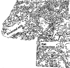
Example of vegetation classification map courtesy of Fort Richardson Natural Resources Office.
Rationale: Wildlife habitats in Anchorage have never been evaluated in a holistic fashion, yet understanding the types, amount, and connections between habitats are key to understanding wildlife population dynamics and making informed land use and management decisions. This habitat assessment will provide the basis for identifying prime habitat lands for conservation protection (Action 1), for targeted tax incentives (Action 3), for targeted habitat conservation ordinances (Action 4), and for assessing Heritage Land Bank lands for potential withdrawals from disposal (an issue related to Action 3).
Responsibilities: ADF&G, USFWS, and the Municipality should co-lead this action, which will require additional inter-agency cooperation from Chugach State Park, the military reservations, BLM, and the University of Alaska -Anchorage. The project could be contracted with researchers from universities or independent firms with the capability to do the work.
Schedule: After funding is secured and a contractor selected, the project will take an estimated 18 to 24 months to complete. For greatest efficiency, the project should be started in the late summer to allow at least two full summer seasons for data collection.
Costs and Funding Sources: Assessments of this type can cost in excess of a million dollars, but may also be scaled back with more limited sampling and field work. Discussions with researchers suggest a high quality assessment as outlined here would range between $150,000 and $200,000. Funding sources have not been identified, but could include funds from the Conservation and Reinvestment Act (CARA). State appropriations to ADF&G or the Municipality are unlikely to cover the costs of a project this large, but might assist to some degree.
Constraints: The high cost of the project is the primary constraint; environmental compliance issues are unlikely to be a problem as most of the work would occur on public land and be short in duration. Some permission to conduct fieldwork on undeveloped private lands may also be a constraint.
2. Key Species Population and Capacity Assessment Program
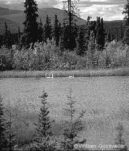
Description. This action is designed to develop improved information about key wildlife populations and trends, their biological carrying capacities, and public “social acceptance capacities.” It would involve 1) periodic scientific efforts to assess wildlife population levels and 2) periodic public surveys (similar to the 1997 effort associated with this plan) to determine tolerance levels for impacts caused by key wildlife. Key species of concern (based on an assessment of management issues) include moose, black and brown bears, Canada geese, wolves, lynx, snowshoe hares and loons. Additional indicator species for assessing biological health might include particular songbirds (for assessing boreal habitats), shorebirds (for assessing wetland or coastal habitats), or macro-invertebrates (for assessing water quality in aquatic habitats).
Rationale. As discussed in Chapter 5, wildlife populations have biological carrying capacities, which are typically defined as the maximum number of individual animals that the existing habitat can support from year to year. Urban wildlife populations also have a “social acceptance capacity,” which is the maximum number of individual animals that a community can tolerate given the impacts those species have on city life. Social acceptance capacities may be higher or lower than the biological capacities for different species, with either case having important implications for management.
For example, a 1997 survey