Areas With Restrictions
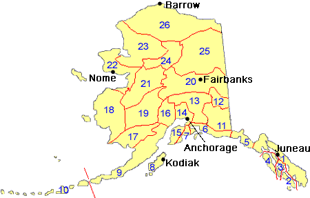
Search By Game Management
Unit (GMU)
Note: Use of these maps indicates that you have read and understand the liability statement.
Select a Game Management Unit.
Game Management Unit
Results for Game Management Unit 20
The following restrictions are those specific to GMU 20. Be sure to check the hunting regulations for additional state-wide hunting and trapping restrictions.
You can check the current status of closures on military land at https://usartrak.isportsman.net/.
Areas Closed to Hunting
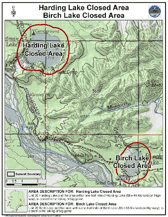
Birch Lake Closed Area
- Restriction: Closed to the taking of big game
- View Map: GIF Map (137 K) PDF Map (307 K)
- Area Description: Unit 20 Birch Lake and the area within one-half mile of Birch Lake (Mile 56 Richardson Highway)
Harding Lake Closed Area
- Restriction: Closed to the taking of big game
- View Map: GIF Map (132 K) PDF Map (324 K)
- Area Description: Unit 20 Harding Lake and the area within one-half mile of Harding Lake (Mile 44 Richardson Highway)
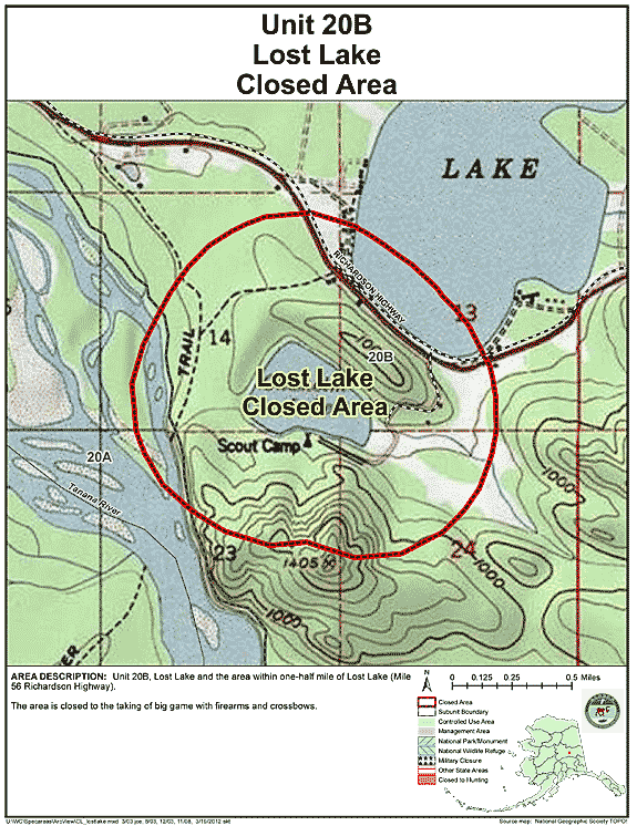
Lost Lake Closed Area
- Restriction: Closed to the taking of big game with firearms and crossbows
- View Map: GIF Map (126 K) PDF Map (229 K)
- Area Description: Unit 20 Lost Lake and the area within one-half mile of Lost Lake (Mile 56 Richardson Highway)
Controlled Use Areas
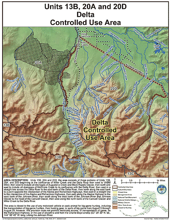
Delta Controlled Use Area
- Restriction: Closed to the use of any motorized vehicle or pack animal for big game hunting, including the transportation of big game hunters, their hunting gear, or parts of big game from August 5 through August 25; however, this provision does not prohibit motorized access, or transportation of game, on the Richardson Highway, or the use of aircraft to and from the Charlie Boyd airstrip (63° 29' 30N. lat., 144° 50' 45"W. long.) along the Johnson River
- View Map: GIF Map (145 K) PDF Map (487 K)
- Area Description: Units 13 and 20; the area consists of those portions of Units 13(B), 20(A), and 20(D) beginning at the confluence of Miller Creek and the Delta River then west to VABM Miller, then west to include all drainages of Augustana Creek and Black Rapids Glacier, then north and east to include all drainages of McGinnis Creek to its confluence with the Delta River, then east in a straight line across the Delta River to the east bank of the Delta River, then north along the east bank to a point opposite the intersection of the Alaska and Richardson Highways, then east in a straight line to the intersection of the Alaska and Richardson Highways, then east along the Alaska Highway to the west bank of the Johnson River, then south along the west bank of the Johnson River and Johnson Glacier to the head of the Canwell Glacier, then west along the north bank of the Canwell Glacier and Miller Creek to the Delta River
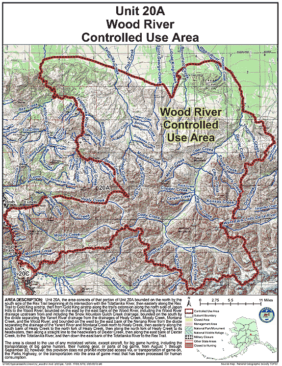
Wood River Controlled Use Area
- Restriction: The area is closed to the use of any motorized vehicle except aircraft for big game hunting, including the transportation of big game hunters, their hunting gear, or parts of big game, from August 1 through September 30; however, this provision does not prohibit motorized access via, or transportation of game on, the Parks Highway; or the transportation into the area of game meat that has been processed for human consumption.
- View Map: GIF Map (167 K) PDF Map (672 K)
- Area Description: The Wood River Controlled Use Area: the area consists of that portion of Unit 20(A) bounded on the north by the south side of the Rex Trail beginning at its intersection with the Totatlanika River, then easterly along the Rex Trail to Gold King airstrip, then from Gold King airstrip along the trail's extension along the north side of Japan Hills to the Wood River; bounded on the east by the east bank of the Wood River, including the Wood River drainage upstream from and including the Snow Mountain Gulch Creek drainage; bounded on the south by the divide separating the Yanert River drainage from the drainages of Healy Creek, Moody Creek, Montana Creek, and the Wood River; and bounded on the west by the east bank of the Nenana River from the divide separating the drainage of the Yanert River and Montana Creek north to Healy Creek, then easterly along the south bank of Healy Creek to the north fork of Healy Creek, then along the north fork of Healy Creek to its headwaters, then along a straight line to the headwaters of Dexter Creek , then along the east bank of Dexter Creek, to the Totatlanika River, and then down the east bank of the Totatlanika River to the Rex Trail
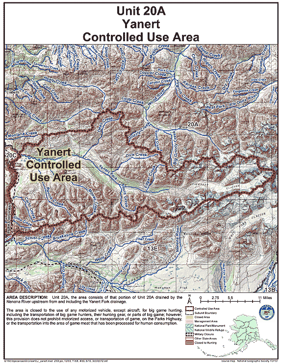
Yanert Controlled Use Area
- Restriction: The area is closed to the use of any motorized vehicle, except aircraft, for big game hunting, including the transportation of big game hunters, their hunting gear, or parts of big game; however, this provision does not prohibit motorized access, or transportation of game, on the Parks Highway, or the transportation into the area of game meat that has been processed for human consumption.
- View Map: GIF Map (165 K) PDF Map (674 K)
- Area Description: The Yanert Controlled Use Area: the area consists of that portion of Unit 20(A) drained by the Nenana River upstream from and including the Yanert Fork drainage
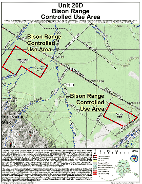
Bison Range Controlled Use Area
- Restriction: The area is closed to motorized vehicles for hunting from July 1 - September 30, including the transportation of hunters, hunting gear, or parts of game in the area; the area consists of two field hunting areas within the Delta Junction Bison Range in Unit 20(D)
- View Map: GIF Map (120 K) PDF Map (228 K)
- Area Description: Delta Junction Bison Range in Unit 20(D):
(i) the Panoramic Field hunting area is located three-quarters of a mile south of the Alaska Highway between Milepost 1404.0 and 1407.6, and bounded by a line beginning at the northeast corner (63ø 53.299' N. lat., 145ø 14.714' W. long.), then northwest 3.5 miles to 63ø 54.956' N. lat., 145ø 20.767' W. long., then southwest 2.4 miles to 63ø 53.206' N. lat., 145ø 23.232' W. long., then southeast 1.5 miles to 63ø 52.537' N. lat., 145ø 20.758' W. long., then northeast 1.0 mile to 63ø 53.301' N.lat., 145ø 19.659' W. long., then southeast 2.0 miles to 63ø 52.330' N. lat., 145ø 16.075' W. long., then northeast 1.0 miles to the beginning point; and
(ii) the Gerstle Field hunting area is located three-quarters of a mile south of the Alaska Highway between Milepost 1394.1 and 1396.8, and bounded by a line beginning at the northeast corner (63ø 48.984' N. lat., 144ø 57.766' W. long.), then northwest 2.9 miles to 63ø 50.242' N. lat., 145ø 02.874' W. long., then southwest 1.1 miles to 63ø 49.102' N. lat., 145ø 04. 197' W. long., then southeast 2.3 miles to 63ø 48.239' N. 1at., 145ø 00.339' W. long., then northeast 1.6 miles to the beginning point.
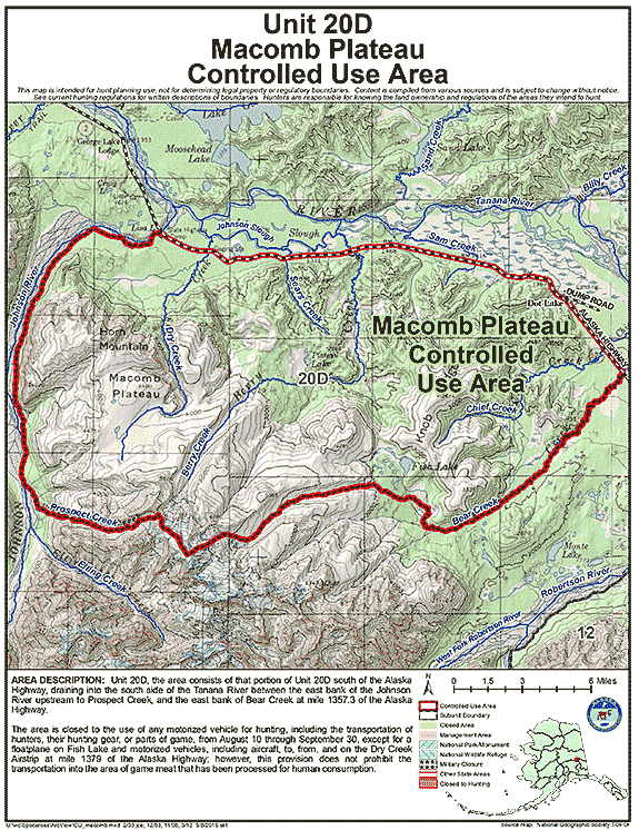
Macomb Plateau Controlled Use Area
- Restriction: The area is closed to the use of any motorized vehicle for hunting, including the transportation of hunters, their hunting gear, or parts of game, from August 10 through September 30, except for a floatplane on Fish Lake and motorized vehicles, including aircraft, to, from, and on the Dry Creek Airstrip at mile 1379 of the Alaska Highway; however, this provision does not apply to the transportation into the area of game meat that has been processed for human consumption.
- View Map: GIF Map (156 K) PDF Map (548 K)
- Area Description: The Macomb Plateau Controlled Use Area: the area consists of that portion of Unit 20(D) south of the Alaska Highway, draining into the south side of the Tanana River between the east bank of the Johnson River upstream to Prospect Creek, and the east bank of Bear Creek at mile 1357.3 of the Alaska Highway
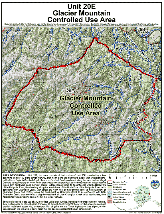
Glacier Mountain Controlled Use Area (GMCUA)
- Restriction: The area is closed to the use of any motorized vehicle for hunting, including the transportation of hunters, their hunting gear, or parts of game, from July 26 through September 20; however, this provision does not prohibit motorized access via, or transportation of game on, the Taylor Highway or any airport or the transportation into the area of game meat that has been processed for human consumption.
- View Map: GIF Map (173 K) PDF Map (630 K)
- Area Description: The Glacier Mountain Controlled Use Area: the area consists of that portion of Unit 20(E) bounded by a line beginning at Mile 140 of the Taylor Highway, then north along the highway to Eagle, then west along the cat trail from Eagle to Crooked Creek, then from Crooked Creek southwest along the west bank of Mogul Creek to its headwaters on North Peak, then west across North Peak to the headwaters of Independence Creek, then southwest along the west bank of Independence Creek to its confluence with the North Fork of the Fortymile River, then easterly along the south bank of the North Fork of the Fortymile River to its confluence with Champion Creek, then across the North Fork of the Fortymile River to the south bank of Champion Creek and easterly along the south bank of Champion Creek to its confluence with Little Champion Creek, then northeast along the east bank of Little Champion Creek to its headwaters, then northeasterly in a direct line to Mile 140 on the Taylor Highway
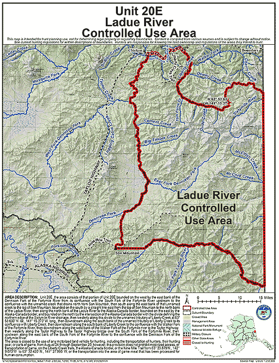
Ladue River Controlled Use Area
- Restriction: The area is closed to the use of any motorized land vehicle for hunting, including the transportation of hunters, their hunting gear, or parts of game, from August 24 through September 20; however, this does not prohibit motorized access, or transportation of game, on the Nine Mile and Liberty Creek trails, the Alaska-Canada border, or the Boundary Cutoff of the Taylor Highway, or the transportation into the area of game meat that has been processed for human consumption; the Nine Mile Trail as referenced in this regulation refers to the single primary ATV trail beginning along the Taylor Highway at 63° 24.233' N. lat., 142° 28.422' W. long., entering the western portion of the defined controlled use area at 63° 23.879' N. lat., 142° 09.073' W. long., and terminating at 63° 32.420' N. lat., 141° 27.995' W. long., only the single primary trail including connected bypasses no more than 20 feet.
- View Map: GIF Map (252 K) PDF Map (2,138 K)
- Area Description: Ladue River Controlled Use Area: the area consists of Unit 20E bounded on the west by the east bank of the Dennison Fork of the Fortymile River from its confluence with the South Fork of the Fortymile River upstream to the confluence with the unnamed creek that drains north from Son Mountain, then south along the east bank of this creek to the top of Son Mountain; on the south by a straight line east from the top of Son Mountain to the north bank of the Ladue River, then along the north bank of the Ladue River to the Alaska-Canada border; on the east by the Alaska-Canada border; and on the north from the intersection of the Alaska-Canada border and the divide on the north side of the mainstem of the Sixtymile drainage, then westerly along this divide to the unnamed tributary of Liberty Creek at N 63° 53.630’, W 141° 15.370’, then downstream along the south bank of the unnamed tributary to its confluence with the mainstem of Liberty Creek, then downstream along the south bank of Liberty Creek to the confluence with the Walker Fork of the Fortymile River then downstream along the west bank of the Walker Fork of the Fortymile River, to the Taylor Highway then westerly along the Taylor Highway to the Taylor Highway bridge over the South Fork of the Fortymile River, then upstream along the east bank of the South Fork of the Fortymile River to the confluence with the Dennison Fork of the Fortymile River.
Management Areas
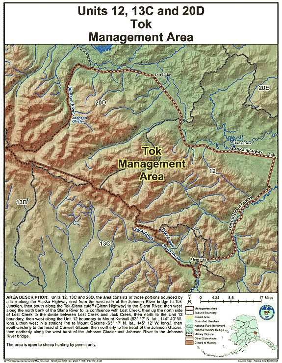
Tok Management Area
- Restriction: Open to sheep hunting by permit only
- View Map: GIF Map (144 K) PDF Map (459 K)
- Area Description: Tok Management Area: the area consists of those portions of Units 12, 13(C), and 20(D) bounded by a line along the Alaska Highway east from the west side of the Johnson River bridge to Tok Junction, then south along the Tok-Slana cutoff (Glenn Highway) to the Slana River; then west along the north bank of the Slana River to its confluence with Lost Creek, then up the north side of Lost Creek to the divide between Lost Creek and Jack Creek, then north to the Unit 12 boundary, then west along the Unit 12 boundary to Mount Kimball (63° 17' N. lat., 144° 40' W. long.), then west in a straight line to Mount Gakona (63° 17' N. lat., 145° 12' W. long.), then southwesterly to the head of Canwell Glacier, then northerly to the head of the Johnson Glacier, then northerly along the west bank of the Johnson Glacier and Johnson River to the Johnson River bridge
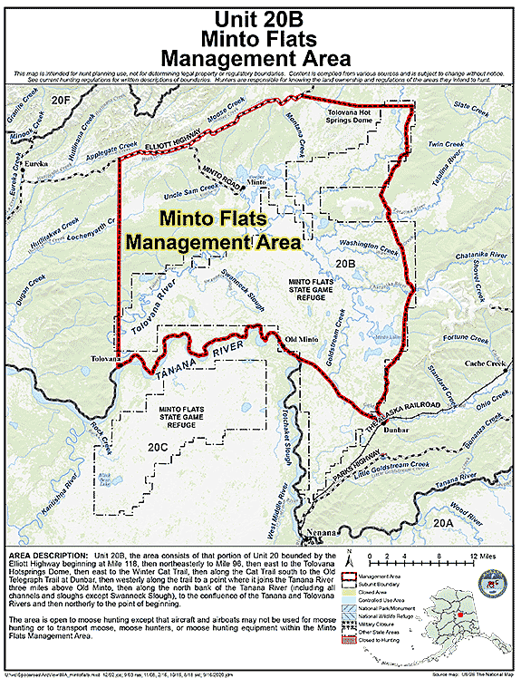
Minto Flats Management Area
- Restriction: Open to moose hunting except that aircraft and airboats may not be used for moose hunting or to transport moose, moose hunters, or moose hunting equipment within the Minto Flats Management Area
- View Map: GIF Map (130 K) PDF Map (451 K)
- Area Description: Minto Flats Management Area: the area consists of that portion of Unit 20 bounded by the Elliott Highway beginning at Mile 118, then northeasterly to Mile 96, then east to the Tolovana Hotsprings Dome, then east to the Winter Cat Trail, then along the Cat Trail south to the Old Telegraph Trail at Dunbar, then westerly along the trail to a point where it joins the Tanana River three miles above Old Minto, then along the north bank of the Tanana River (including all channels and sloughs except Swanneck Slough), to the confluence of the Tanana and Tolovana Rivers and then northerly to the point of beginning
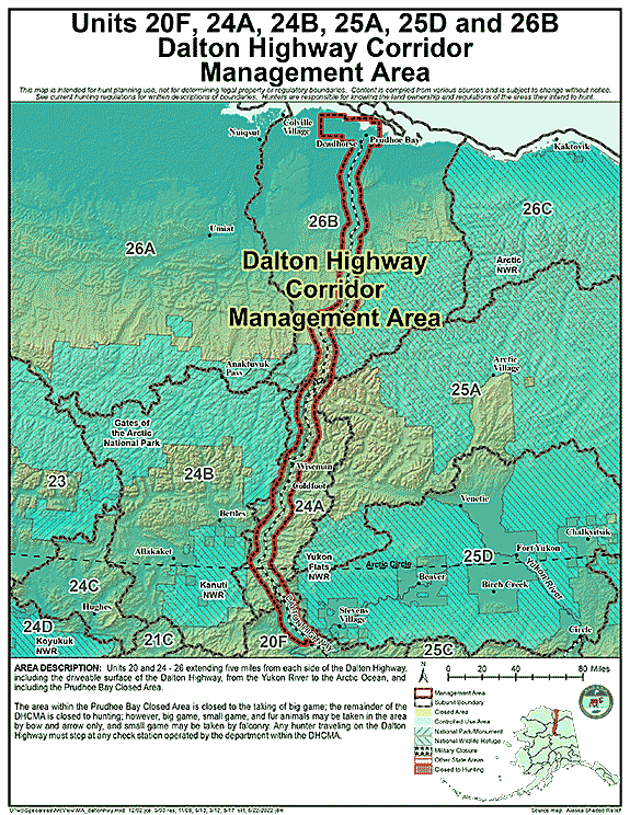
Dalton Highway Corridor Management Area
- Restriction: The area within the Prudhoe Bay Closed Area is closed to the taking of big game; the remainder of the DHCMA is closed to hunting; however, big game, small game, and fur animals may be taken in the area by bow and arrow only, and small game may be taken by falconry.
Any hunter traveling on the Dalton Highway must stop at any check station operated by the department within the DHCMA - View Map: GIF Map (137 K) PDF Map (657 K)
- Area Description: Dalton Highway Corridor Management Area (DHCMA): the portions of Units 20 and 24-26 extending five miles from each side of the Dalton Highway, including the driveable surface of the Dalton Highway, from the Yukon River to the Arctic Ocean, and including the Prudhoe Bay Closed Area
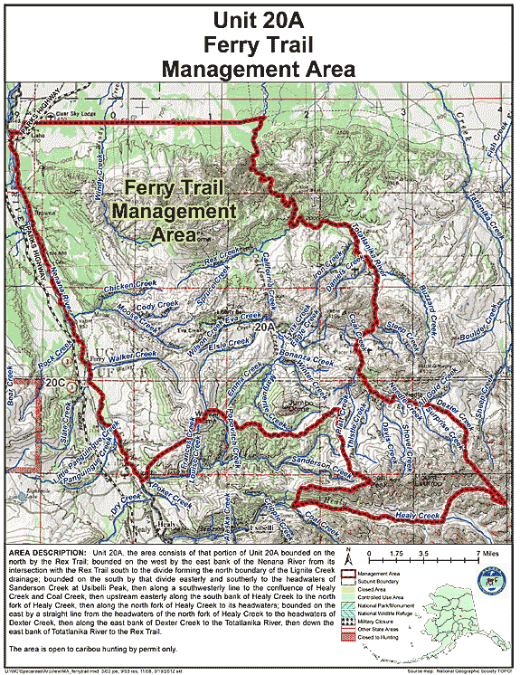
Ferry Trail Management Area
- Restriction: Caribou hunting by permit only
- View Map: GIF Map (156 K) PDF Map (556 K)
- Area Description: Ferry Trail Management Area: the area consists of that portion of Unit 20(A) bounded on the north by the Rex Trail; bounded on the west by the east bank of the Nenana River from its intersection with the Rex Trail south to the divide forming the north boundary of the Lignite Creek drainage; bounded on the south by that divide easterly and southerly to the headwaters of Sanderson Creek at Usibelli Peak, then along a southwesterly line to the confluence of Healy Creek and Coal Creek, then upstream easterly along the south bank of Healy Creek to the north fork of Healy Creek, then along the north fork of Healy Creek to its headwaters; bounded on the east by a straight line from the headwaters of the north fork of Healy Creek to the headwaters of Dexter Creek, then along the east bank of Dexter Creek to the Totatlanika River, then down the east bank of Totatlanika River to the Rex Trail
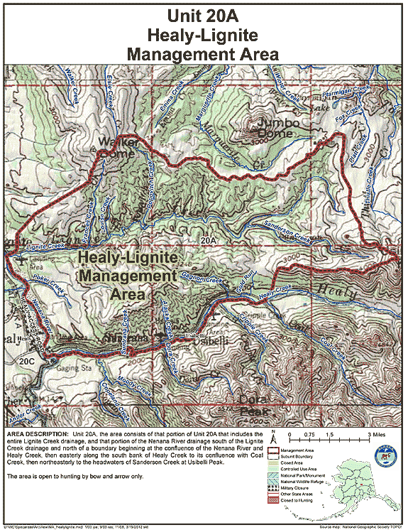
Healy-Lignite Management Area
- Restriction: Open to hunting by bow and arrow only;
- View Map: GIF Map (155 K) PDF Map (417 K)
- Area Description: Healy-Lignite Management Area: the area consists of that portion of Unit 20(A) that includes the entire Lignite Creek drainage, and that portion of the Nenana River drainage south of the Lignite Creek drainage and north of a boundary beginning at the confluence of the Nenana River and Healy Creek, then easterly along the south bank of Healy Creek to its confluence with Coal Creek, then northeasterly to the headwaters of Sanderson Creek at Usibelli Peak
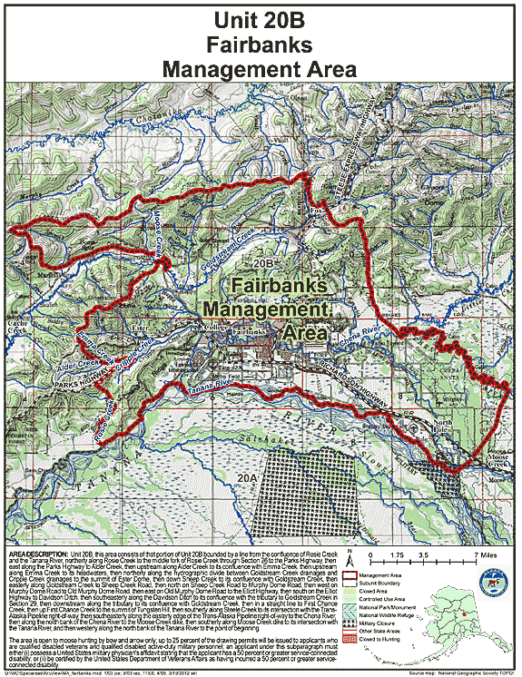
Fairbanks Management Area
- Restriction: (B) the area is open to moose hunting by bow and arrow only, except that the portion within Creamer's Refuge is open to moose hunting by bow and arrow and muzzleloader only;
(C) up to 25 percent of the drawing permits will be issued to applicants who are qualified disabled veterans and qualified disabled active-duty military personnel; an applicant under this subparagraph must either
(i) possess a United States military physician's affidavit stating that the applicant has a 50 percent or greater service-connected disability; or
(ii) be certified by the United States Department of Veterans Affairs as having incurred a 50 percent or greater service-connected disability; - View Map: GIF Map (165 K) PDF Map (613 K)
- Area Description: Fairbanks Management Area: this area consists of that portion of Unit 20(B) bounded by a line from the confluence of Rosie Creek and the Tanana River, northerly along Rosie Creek to the middle fork of Rosie Creek through Section 26 to the Parks Highway, then east along the Parks Highway to Alder Creek, then upstream along Alder Creek to its confluence with Emma Creek, then upstream along Emma Creek to its headwaters, then northerly along the hydrographic divide between Goldstream Creek drainages and Cripple Creek drainages to the summit of Ester Dome, then down Sheep Creek to its confluence with Goldstream Creek, then easterly along Goldstream Creek to Sheep Creek Road, then north on Sheep Creek Road to Murphy Dome Road, then west on Murphy Dome Road to Old Murphy Dome Road, then east on Old Murphy Dome Road to the Elliot Highway, then south on the Elliot Highway to Davidson Ditch, then southeasterly along the Davidson Ditch to its confluence with the tributary to Goldstream Creek in Section 29, then downstream along the tributary to its confluence with Goldstream Creek, then in a straight line to First Chance Creek, then up First Chance Creek to the summit of Tungsten Hill, then southerly along Steele Creek to its intersection with the Trans-Alaska Pipeline right-of-way, then southeasterly along the easterly edge of the Trans-Alaska Pipeline right-of-way to the Chena River, then along the north bank of the Chena River to the Moose Creek dike, then southerly along the Moose Creek dike to its intersection with the Tanana River, and then westerly along the north bank of the Tanana River to the point of beginning
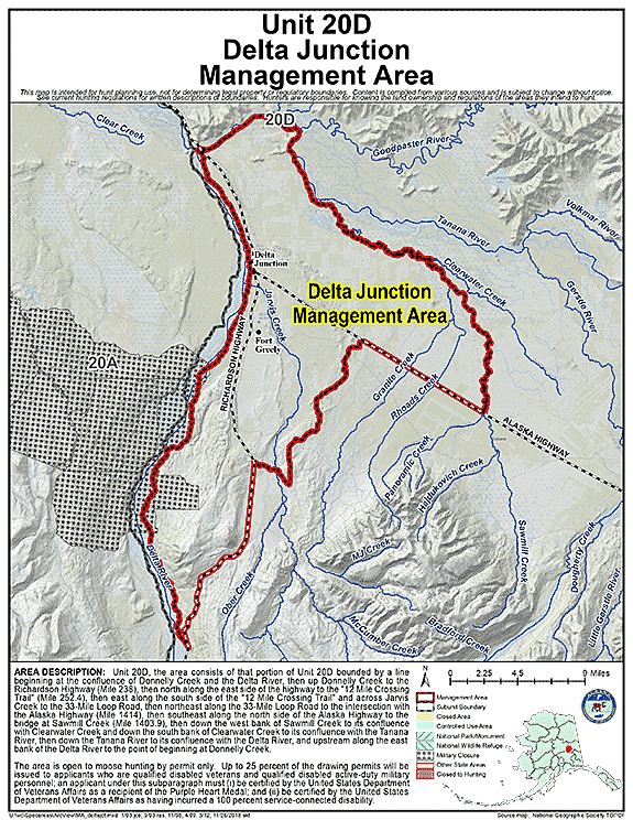
Delta Junction Management Area
- Restriction: (B) The area is open to moose hunting by permit only
(C) up to 25 percent of the drawing permits will be issued to applicants who are qualified disabled veterans and qualified disabled active-duty military personnel; an applicant under this subparagraph must
(i) be certified by the United States Department of Veterans Affairs as a recipient of the Purple Heart Medal; and
(ii) be certified by the United States Department of Veterans Affairs as having incurred a 100 percent service-connected disability; - View Map: GIF Map (148 K) PDF Map (490 K)
- Area Description: Delta Junction Controlled Use Area: The area consists of that portion of Unit 20(D) bounded by a line beginning at the confluence of Donnelly Creek and the Delta River, then up Donnelly Creek to the Richardson Highway (Mile 238), then north along the east side of the highway to the "12 Mile Crossing Trail" (Mile 252.4), then east along the south side of the "12 Mile Crossing Trail" and across Jarvis Creek to the 33-Mile Loop Road, then northeast along the 33-Mile Loop Road to the intersection with the Alaska Highway (Mile 1414), then southeast along the north side of the Alaska Highway to the bridge at Sawmill Creek (Mile 1403.9), then down the west bank of Sawmill Creek to its confluence with Clearwater Creek and down the south bank of Clearwater Creek to its confluence with the Tanana River, then down the Tanana River to its confluence with the Delta River, and upstream along the east bank of the Delta River to the point of beginning at Donnelly Creek
State Refuges
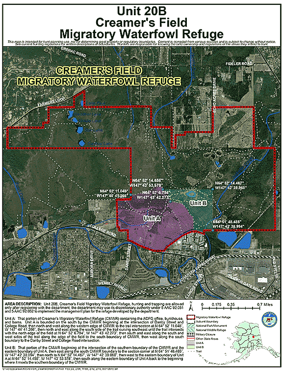
Creamer's Field Migratory Waterfowl Refuge
- Restriction: Hunting and trapping are allowed only after registering with the department; the department may use its discretionary authority under 5 AAC 92.051 to implement the management plan for the refuge developed by the department.
- View Map: GIF Map (137 K) PDF Map (395 K)
- Area Description: Unit 20 - In the Creamer's Field Migratory Waterfowl Refuge
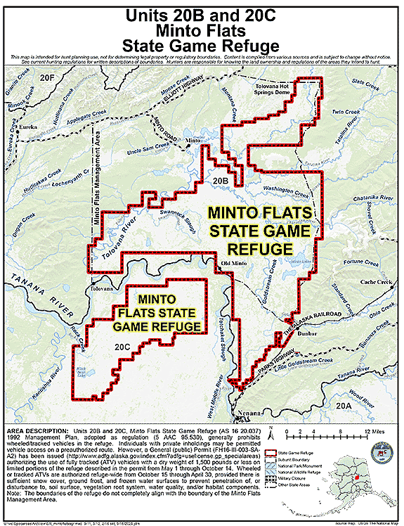
Minto Flats State Game Refuge
- Restriction: Minto Flats State Game Refuge 1992 Management Plan, adopted as regulation (5 AAC 95.530), generally prohibits wheeled/tracked vehicles in the refuge. Individuals with private inholdings may be permitted vehicle access on a preauthorized route. However, a General (public) Permit (FH16-III-003-SA-A2) has been issued (http://www.adfg.alaska.gov/index.cfm?adfg=uselicense.gp_specialareas) authorizing the use of fully tracked (ATV) vehicles with a dry weight of 1,500 pounds or less on limited portions of the refuge described in the permit from May 1 through October 14. Wheeled or tracked ATVs are authorized refuge-wide from October 15 through April 30, provided there is sufficient snow cover, ground frost, and frozen water surfaces to prevent penetration of, or disturbance to, soil surface, vegetation root system, water quality, and/or habitat components.
- View Map: GIF Map (132 K) PDF Map (449 K)
- Area Description: Units 20B and 20C, Minto Flats State Game Refuge as described in AS 16.20.037
To view the refuge management plan and General Permits for a complete description of areas authorized for vehicle use, contact ADF&G Fairbanks office 907-459-7289 or visit http://hunt.alaska.gov
Note: The boundaries of the refuge do not completely align with the boundary of the Minto Flats Management Area.
Note: Changes to area restrictions for hunting and trapping by Emergency Orders may not be shown on this page. Please be sure to check the Emergency Orders page for the most current list of changes.