Areas With Restrictions
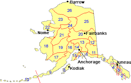
Search By Game Management
Unit (GMU)
Note: Use of these maps indicates that you have read and understand the liability statement.
Select a Game Management Unit.
Game Management Unit
Results for Game Management Unit 1
The following restrictions are those specific to GMU 1. Be sure to check the hunting regulations for additional state-wide hunting and trapping restrictions.
Areas Closed to Hunting
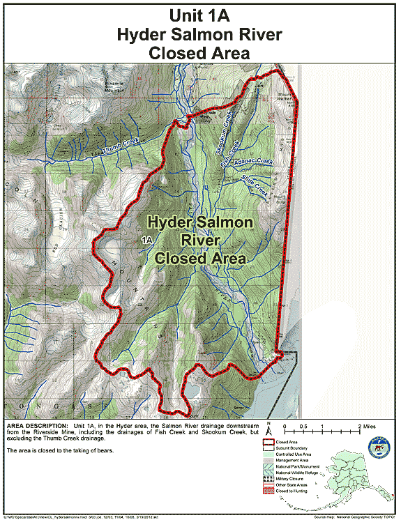
Hyder Salmon River Closed Area
- Restriction: Closed to the taking of bears
- View Map: GIF Map (126 K) PDF Map (327 K)
- Area Description: Unit 1(A) in the Hyder area, the Salmon River drainage downstream from the Riverside Mine, including the drainages of Fish Creek and Skookum Creek, but excluding the Thumb Creek drainage
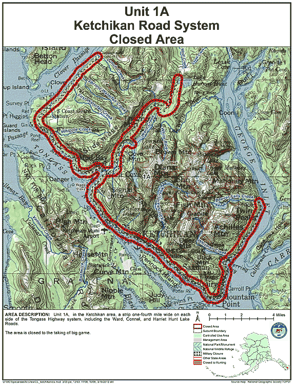
Ketchikan Road System Closed Area
- Restriction: Closed to the taking of big game
- View Map: GIF Map (151 K) PDF Map (428 K)
- Area Description: Unit 1(A) in the Ketchikan area, a strip one-fourth mile wide on each side of the Tongass Highway system, including the Ward, Connel, and Harriet Hunt Lake Roads
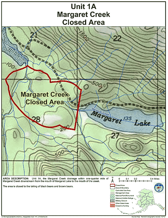
Margaret Creek Closed Area
- Restriction: Closed to taking any bear
- View Map: GIF Map (124 K) PDF Map (218 K)
- Area Description: Unit 1(A), the Margaret Creek drainage within 1/4 mile of Margaret Creek downstream from the mouth of Margaret Lake to the mouth of the Creek
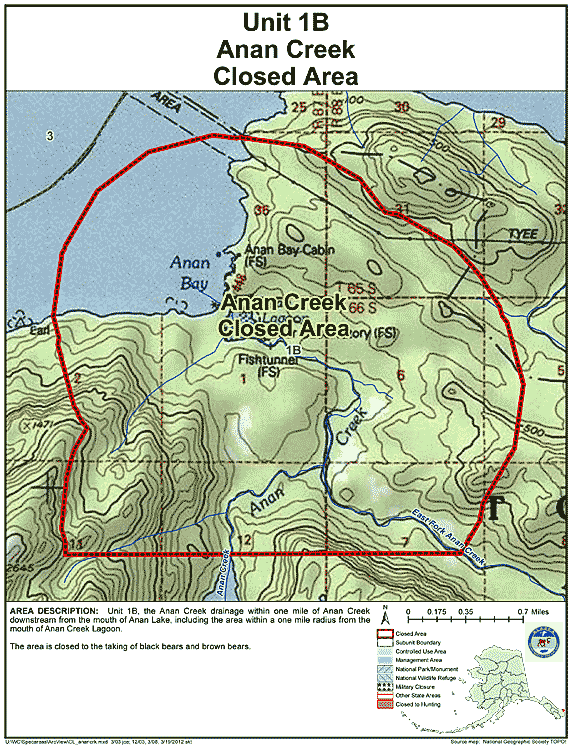
Anan Creek Closed Area
- Restriction: Closed to the taking of black bears and brown bears
- View Map: GIF Map (131 K) PDF Map (254 K)
- Area Description: Unit 1(B) the Anan Creek drainage within one mile of Anan Creek downstream from the mouth of Anan Lake, including the area within a one mile radius from the mouth of Anan Creek Lagoon
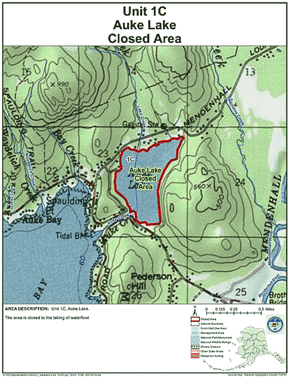
Auke Lake Closed Area
- Restriction: Closed to the taking of waterfowl
- View Map: GIF Map (127 K) PDF Map (229 K)
- Area Description: Unit 1(C) Auke Lake
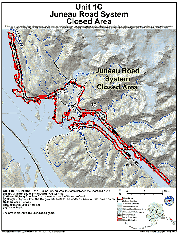
Juneau Road System Closed Area
- Restriction: Closed to the taking of big game
- View Map: GIF Map (129 K) PDF Map (449 K)
- Area Description: Unit 1C, in the Juneau area, that area between the coast and a line one-fourth mile inland of the following road systems: (i) Glacier Highway from Mile 0 to the northern bank of Peterson Creek; (ii) Douglas Highway from the Douglas city limits to the northeast bank of Fish Creek on the North Douglas Highway; (iii) Mendenhall Loop Road; and (iv) Thane Road.
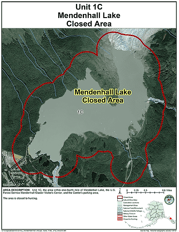
Mendenhall Lake Closed Area
- Restriction: Closed to hunting
- View Map: GIF Map (108 K) PDF Map (251 K)
- Area Description: Unit 1(C) the area within one-fourth mile of Mendenhall Lake, the U.S. Forest Service Mendenhall Glacier Visitor's Center, and the Center's parking area
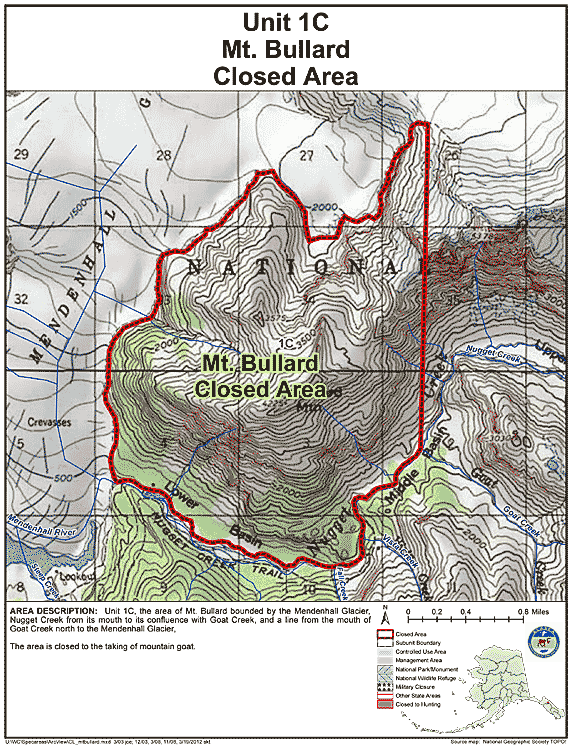
Mt. Bullard Closed Area
- Restriction: Closed to the taking of mountain goat
- View Map: GIF Map (143 K) PDF Map (298 K)
- Area Description: Unit 1(C) the area of Mt. Bullard bounded by the Mendenhall Glacier, Nugget Creek from its mouth to its confluence with Goat Creek, and a line from the mouth of Goat Creek north to the Mendenhall Glacier
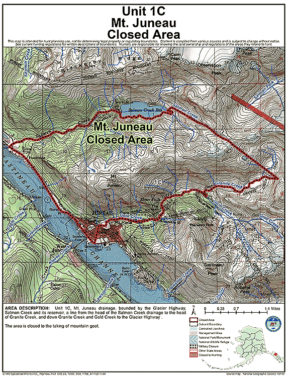
Mt. Juneau Closed Area
- Restriction: Closed to the taking of mountain goat
- View Map: GIF Map (157 K) PDF Map (324 K)
- Area Description: Unit 1(C) Mt. Juneau drainage, bounded by the Glacier Highway, Salmon Creek and its reservoir, a line from the head of the Salmon Creek drainage to the head of Granite Creek, and down Granite Creek and Gold Creek to the Glacier Highway
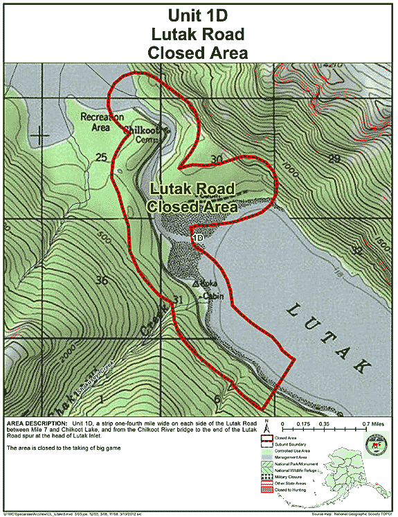
Lutak Road Closed Area
- Restriction: Closed to the taking of big game
- View Map: GIF Map (132 K) PDF Map (251 K)
- Area Description: Unit 1(D) a strip one-fourth mile wide on each side of the Lutak Road between Mile 7 and Chilkoot Lake, and from the Chilkoot River bridge to the end of the Lutak Road spur at the head of Lutak Inlet
State Refuges
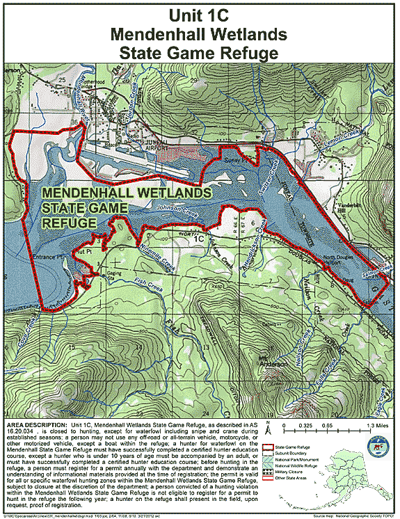
Mendenhall Wetlands State Game Refuge
- Restriction: The area is closed to hunting, except for waterfowl including snipe and crane during established seasons; a person may not use any off-road or all-terrain vehicle, motorcycle, or other motorized vehicle, except a boat within the refuge; a hunter for waterfowl on the Mendenhall State Game Refuge must have successfully completed a certified hunter education course, except a hunter who is 12 years of age or younger must be accompanied by an adult 21 years of age or older who has successfully completed a certified hunter education course, or must have successfully completed a certified hunter education course; before hunting in the refuge, a person must register for a permit annually with the department and demonstrate an understanding of informational materials provided at the time of registration; the permit is valid for all or specific waterfowl hunting zones within the Mendenhall Wetlands State Game Refuge, subject to closure at the discretion of the department; a person convicted of a hunting violation within the Mendenhall Wetlands State Game Refuge is not eligible to register for a permit to hunt in the refuge the following year; a hunter on the refuge shall present in the field, upon request, proof of registration; the first two days of the established waterfowl season is open to youth hunters 17 years of age or younger who are accompanied by a licensed hunter 21 years of age or older who has successfully completed a certified hunter education course and both the child and accompanying adult must register with the department.
- View Map: GIF Map (241 K) PDF Map (1,932 K)
- Area Description: Unit 1 - The Mendenhall Wetlands State Game Refuge, as described in AS 16.20.034
Areas Closed to Trapping
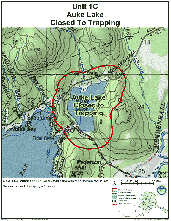
Unit 1(C) Auke Lake
- Restriction: Closed to the trapping of furbearers
- View Map: GIF Map (129 K) PDF Map (232 K)
- Area Description: Unit 1(C) Auke Lake and the area within one-quarter mile of Auke Lake
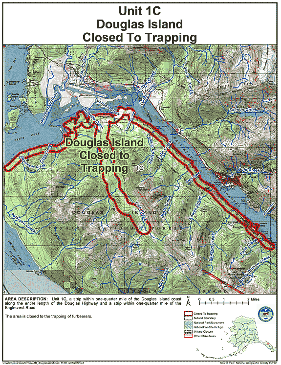
Unit 1(C) Douglas Island
- Restriction: Closed to the trapping of furbearers
- View Map: GIF Map (148 K) PDF Map (520 K)
- Area Description: Unit 1(C) a strip within one-quarter mile of the Douglas Island coast along the entire length of the Douglas Highway and a strip within one-quarter mile of the Eaglecrest Road
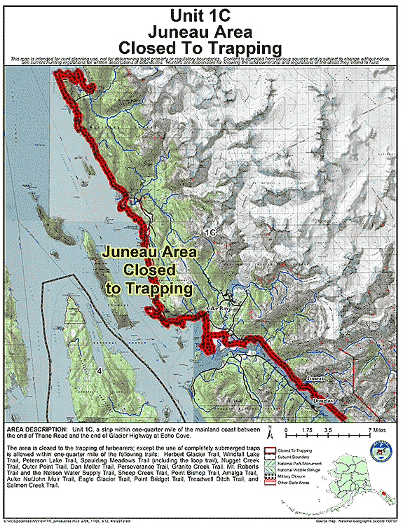
Unit 1(C) Juneau Area
- Restriction: The area is closed to the trapping of furbearers; except the use of completely submerged traps is allowed within one-quarter mile of the following trails: Herbert Glacier Trail, Windfall Lake Trail, Peterson Lake Trail, Spaulding Meadows Trail (including the loop trail), Nugget Creek Trail, Outer Point Trail, Dan Moller Trail,
- View Map: GIF Map (133 K) PDF Map (329 K)
- Area Description: Unit 1(C) (Juneau area): a strip within one-quarter mile of the mainland coast between the end of Thane Road and the end of Glacier Highway at Echo Cove
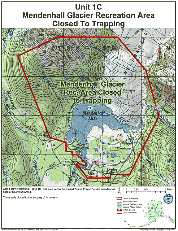
Unit 1(C) Mendenhall Glacier Recreation Area
- Restriction: Closed to the trapping of furbearers
- View Map: GIF Map (140 K) PDF Map (311 K)
- Area Description: Unit 1(C) that area within the United States Forest Service Mendenhall Glacier Recreation Area
Unit 1(C) Mendenhall Valley
- Restriction: Closed to the trapping of furbearers
- View Map: GIF Map (140 K) PDF Map (299 K)
- Area Description: Unit 1(C) that area of the Mendenhall Valley bounded on the south by the Glacier Highway, on the west by the Mendenhall Loop Road and Montana Creek Road and Spur Road to Mendenhall Lake, on the north by Mendenhall Lake, and on the east by the Mendenhall Loop Road and Forest Service Glacier Spur Road to the Forest Service Visitor Center
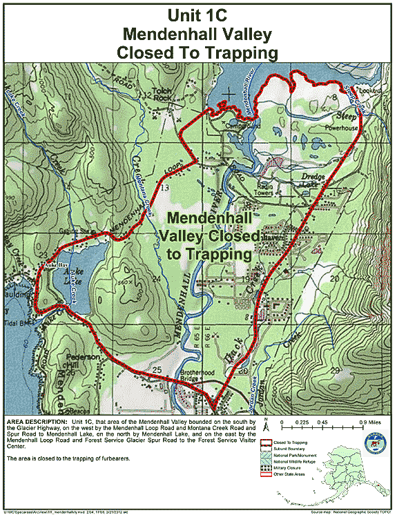
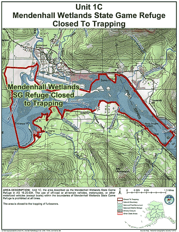
Unit 1(C) Mendenhall Wetlands State Game Refuge
- Restriction: Closed to the trapping of furbearers
- View Map: GIF Map (143 K) PDF Map (361 K)
- Area Description: Unit 1(C) the area described as the Mendenhall Wetlands State Game Refuge in AS 16.20.034 is closed to trapping; the use of off-road or all-terrain vehicles, motorcycles, or other motorized vehicles (except boats) within the boundaries of Mendenhall Wetlands State Game Refuge is prohibited at all times
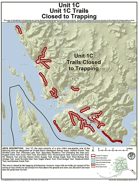
Unit 1(C) Trails
- Restriction: Closed to the trapping of furbearers; however, traps with an inside jaw spread of five inches or less which are set at least five feet above the ground and snow are allowed if set more than 50 yards from the trail
- View Map: GIF Map (109 K) PDF Map (268 K)
- Area Description: Unit 1(C) a strip within one-quarter mile of the following trails as designated on United States Geological Survey maps: Herbert Glacier Trail, Windfall Lake Trail, Peterson Lake Trail, Spaulding Meadows Trail (including the loop trail), Nugget Creek Trail, Outer Point Trail, Dan Moller Trail, Perseverance Trail, Granite Creek Trail, Mt. Roberts Trail and the Nelson Water Supply Trail, Sheep Creek Trail, Point Bishop Trail, Amalga Trail, Auke Nu/John Muir Trail, Eagle Glacier Trail, Point Bridget Trail, Treadwell Ditch Trail, and Salmon Creek Trail
Note: Changes to area restrictions for hunting and trapping by Emergency Orders may not be shown on this page. Please be sure to check the Emergency Orders page for the most current list of changes.