Kuskokwim River Area
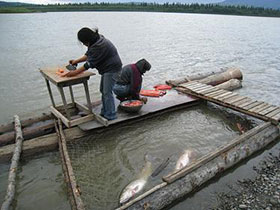
Subsistence Fishing
Overview
 The Kuskokwim River originates on the western slope of the Alaska Range and drains into the
Bering Sea at the Yukon-Kuskokwim delta. Extending for 724 miles, it is the second largest river in Alaska.
In terms of average volume of water flowing out of the river each year, the Kuskokwim is the ninth largest river
in the United States. It is also the longest river to exist exclusively within one US state. The Kuskokwim
drainage contains 38 communities and an approximate total of 4,600 households. The Kuskokwim River region
can be defined, both geographically and culturally, by three regions; lower, middle, and upper. The lower
Kuskokwim region consists of the Kuskokwim Delta area extending from the community of Lower Kalskag to the
river's mouth at Kuskokwim Bay and the Bering Sea. The lower river can be culturally defined as predominantly
Yup'ik, but includes a relatively high number of Euro-American residents concentrated around the community of
Bethel, the river's regional hub located 340 miles west of Anchorage and home to approximately 6,500 residents.
The middle Kuskokwim region consists of the river extending northwest from community of Aniak through the community
of Stony River, including Lime Village. Culturally, the middle Kuskokwim contains Athabascan, Yup'ik, and Euro-American
residents. The upper Kuskokwim region includes the communities of Takotna, McGrath, Medfra, and Nikolai, and extends
into the major tributaries that make up the river�s headwaters. Culturally the upper Kuskokwim is predominantly
Athabascan, alongside mainly Euro-American residents whom reside primarily in McGrath.
The Kuskokwim River originates on the western slope of the Alaska Range and drains into the
Bering Sea at the Yukon-Kuskokwim delta. Extending for 724 miles, it is the second largest river in Alaska.
In terms of average volume of water flowing out of the river each year, the Kuskokwim is the ninth largest river
in the United States. It is also the longest river to exist exclusively within one US state. The Kuskokwim
drainage contains 38 communities and an approximate total of 4,600 households. The Kuskokwim River region
can be defined, both geographically and culturally, by three regions; lower, middle, and upper. The lower
Kuskokwim region consists of the Kuskokwim Delta area extending from the community of Lower Kalskag to the
river's mouth at Kuskokwim Bay and the Bering Sea. The lower river can be culturally defined as predominantly
Yup'ik, but includes a relatively high number of Euro-American residents concentrated around the community of
Bethel, the river's regional hub located 340 miles west of Anchorage and home to approximately 6,500 residents.
The middle Kuskokwim region consists of the river extending northwest from community of Aniak through the community
of Stony River, including Lime Village. Culturally, the middle Kuskokwim contains Athabascan, Yup'ik, and Euro-American
residents. The upper Kuskokwim region includes the communities of Takotna, McGrath, Medfra, and Nikolai, and extends
into the major tributaries that make up the river�s headwaters. Culturally the upper Kuskokwim is predominantly
Athabascan, alongside mainly Euro-American residents whom reside primarily in McGrath.