General Permits
Stream Crossings
General Permits have been issued for stream crossing at authorized locations in many areas of the state. Please review the permit and retain a copy in possession when conducting the authorized activity.
| Cache Creek Trail | FH 18-IV-0006-GP (PDF 626 kB) |
Cache Creek; Sections 15, 21 and 31 T. 28 N., R. 9 W., S.M. (seven crossing locations)
Section 1, T. 27 N., R. 10 W., S.M. Nugget Creek; Section 15, T. 28 N., R. 9 W., S.M. Thunder Creek; Section 30, T. 28 N, R9W, S.M. |
See map in permit document |
|---|---|---|
| Colorado Road Trail | ||
| FH 15-1-0143-GP (PDF 655 kB) |
Sec 4, T 28 S, R 34E, CRM (YAK C-5);
Unnamed Tributary to the Lost River |
Map -Colorado Road Trail (Image file 181 kB) |
| Copper River Drainage | ||
| FH26-III-0011-GP (PDF 711 kB) |
Ahtell Creek
|
Ahtell Creek Crossings (PDF 3,298 kB) |
| FH26-III-0010-GP (PDF 648 kB) |
(Upper) Copper River & Suslota Creek
|
Upper Copper River Drainage Crossings (PDF 3,086 kB) |
| FH26-III-0014-GP (PDF 675 kB) |
Copper River & Kotsina River
|
Copper & Kotsina River Crossings (PDF 3,556 kB) |
| FH26-III-0015-GP (PDF 1,172 kB) |
Copper River
O'Brien Creek Haley Creek |
Chitina Area Crossings (PDF 791 kB) |
| FH26-III-0013-GP (PDF 2,053 kB) |
(Middle and West Fork) Gulkana River & Tributaries
|
Middle and West Fork Gulkana River Drainage Crossings (PDF 1,585 kB) |
| FH26-III-0013-GP (PDF 648 kB) | (Upper) Gulkana & Gakona Rivers & Tributaries | Upper Gulkana & Gakona River Drainage Crossings (PDF 2,747 kB) |
| FH26-III-0013-GP (PDF 763 kB) |
(Upper) Slana River & Tributaries
|
Upper Slana River Drainage Crossings (PDF 4,392 kB) |
| FH26-III-0084-GP (PDF 526 kB) |
Squirrel Creek
|
Squirrel Creek Crossing Map (PDF 1,714 kB) |
| Deception Creek | ||
| FH23-IV-0019-GP (PDF 546 kB) |
Sections 11 and 12, T. 19 N., R. 4 W., S.M.
|
See map in permit document |
| Dow Island Slough - Kenai River | ||
| FH22-V-0018-GP (PDF 824 kB) |
Section 27, T5N, R8W, S.M.
|
Map - Dow Island Slough Crossing (PDF 364 kB) |
| Eagle Creek | ||
| FH22-I-0007-GP (PDF 855 kB) |
Section 26, T53S, R61E, CRM
Forest Road 7595 |
See map in permit document |
| East (Alsek) River Area | ||
| FH26-I-0028-GP (PDF 591 kB) |
ATV crossings in the East River fishing area
Sections 25-28 and 34-36, T32S, R41E, CRM |
See map in permit document |
| Eska Creek | ||
| FH23-IV-0026-GP (PDF 581 kB) |
Eska Creek; Section 27 & 28, T. 19 N., R. 3 E., S.M.
Matanuska River; Section 28, 29, 32 & 33, T. 19. N., R. 3 E., S. M. |
See map in permit document |
| Fox Creek | ||
| FH24-V-0009-GP (PDF 497 kB) |
Section 30, T4S, R10W, SM; ATV Ford
|
See map in permit document |
| Goose Creek | ||
| FH23-IV-0002-GP (PDF 619 kB) |
SE 1/4 Section 10, T23N, R4W, SM; South Tom Price Road
|
See map in permit document |
| Gulf Coast Streams | ||
| FH22-I-0060-GP (PDF 621 kB) |
Gulft Coast streams between Icy Bay and Cape Yakataga
|
See map in permit document |
| Ibeck Creek | ||
| FH19-II-0059 (PDF 2,944 kB) |
Sections 24, 25, & 26, T. 15 S., R. 2 W., C.R.M. Section 19, T. 15 S., R. 1 W., C.R.M.
|
See map in permit document |
| Indian River | ||
| FH 17-I-0162-GP (PDF 917 kB) |
Section 25, T. 46S, R. 62E, CRM
|
See map in permit document |
| Jim Creek/Knik Glacier Trail Tributaries | ||
| FH23-IV-0001-GP (PDF 1,309 kB) |
Bodenburg Creek; NE 1/4 Section 2, T16N, R2E, SM
Friday Creek; Sections 7, 8 & 17, T16N, R4E, SM Jim Creek; Section 32, T17N, R3E, SM Knik River; Sections 1 & 2, T16N, R2E, SM Knik River; Sections 31 - 34, T17N, R3E, SM Knik River; Sections 1, 2, 3 & 12, T16N, R3E, SM Knik River; Sections 7 & 8, T16N, R4E, SM |
See map in permit document |
| Kenai Borough | ||
| FH24-V-0001-GP (PDF 403 kB) |
Frozen Water Surface crossings in the Kenai Borough
|
No map |
| Kings River | ||
| FH23-IV-0022-GP (PDF 563 kB) |
Section 36.T. 20 N.,R., 04 E
|
See map in permit document |
| Kinzarof Lagoon | ||
| FH22-II-0078-GP (PDF 815 kB) |
Vehicle stream crossings in the Kinzarof Lagoon watershed below the mean high water line.
|
See map in permit document |
| Klehini River | ||
| FH18-I-0062-GP (PDF 1,887 kB) |
Mile 34 Haines Hwy, Porcupine Spur Road, Section 21 & 22, T28S, R53E, CRM
|
See aerial photos in permit document |
| Kodiak Island Streams | ||
| FH24-II-0043-GP (PDF 35,752 kB) |
American River and Tributaries
Saltery Cove Road Sections 29 and 31, T29S, R20W, SM Sections 2, 3, 9, 10, and 16, T30S, R21W, SM |
See map in permit document |
| FH25-II-0062-GP (PDF 7,685 kB) |
Burma Creek - Unnamed Stream; Section 9, T28S, R20W, SM
|
See map in permit document |
| FH23-II-0054-GP (PDF 711 kB) |
Burton Ranch Road, Unnamed stream; NE 1/4 Section 22, T31S, R19W, SM
Burton Ranch Road, Unnamed stream; SE 1/4 Section 15, T31S, R19W, SM |
See map in permit document |
| FH25-II-0103-GP (PDF 1,183 kB) |
Chiniak River; Section 32, T29S, R18W, SM
|
See map in permit document |
| FH24-II-0050-GP (PDF 10,006 kB) |
Gracy Creek; Section 18, T31S, R21W, SM
|
See map in permit document |
| FH23-II-0049-GP (PDF 651 kB) |
Hurst Creek; SE 1/4 Section 12, T31S, R22W, SM
|
See map in permit document |
| FH23-II-0052-GP (PDF 646 kB) |
Joe Creek; SE 1/4 Section 30, T31S, R20W, SM
|
See map in permit document |
| FH25-II-0063-GP (PDF 6,245 kB) |
Mayflower Lake Outlet Stream; Section 23, T29S, R20W, SM
|
See map in permit document |
| FH24-II-0051-GP (PDF 12,408 kB) |
Miam River; Sections 14 and 23, T31S, R21W, SM
Unnamed Tributary Miam River; Sections 13 and 14, T31S, R21W, SM |
See map in permit document |
| FH24-II-0044-GP (PDF 10,557 kB) |
Olds River - Unnamed tributary; Section 16, T30S, R20W, SM
Olds River - Unnamed tributary; Section 10, T30S, R20W, SM |
See map in permit document |
| FH24-II-0041-GP (PDF 11,025 kB) |
Pillar Creek; SW 1/4 Section 30, T27S, R19W, SM
|
See map in permit document |
| FH25-II-0060-GP (PDF 16,415 kB) |
Rough Creek; Sections 34, T30S, R22W., SM
|
See map in permit document. |
| FH24-II-0064-GP (PDF 9,238 kB) |
Russian Creek; Section 2, T29S, R21W., SM
|
See map in permit document. |
| FH23-II-0046-GP (PDF 711 kB) |
Sacramento River; NE 1/4 Section 2, T31S, R19W, SM
|
See map in permit document |
| FH24-II-0057-GP (PDF 13,064 kB) |
Saltery Creek and Unnamed Streams
|
See map in permit document |
| FH24-II-0042-GP (PDF 16,711 kB) |
Sargent Creek; NW 1/4 Section 36, T28S, R21W, SM
|
See map in permit document |
| FH24-II-0047-GP (PDF 5,787 kB) |
Sequel Point Creek; Section 20, T30S, R18W, SM
|
See map in permit document |
| FH23-II-0039-GP (PDF 610 kB) |
Unnamed Tributary - Devils Creek; Section 20, T28S, R20W, SM
|
See map in permit document |
| FH24-II-0061-GP (PDF 6,320 kB) |
Unnamed Tributary - Panamaroff Creek; Section 1, T29S, R21W, SM
|
See map in permit document |
| FH23-II-0053-GP (PDF 623 kB) |
Zenter Creek; SW 1/4 Section 22, T31S, R20W, SM
Section 21, T31S, R20W, SM Section 16, T31S, R20W, SM Unnamed Tributary Zentner Creek; Section 21, T31S, R20W, SM |
See map in permit document |
| Kruzof Island | ||
| FH26-I-0016-GP (PDF 1,978 kB) |
Multiple locations - Kruzof Island Road System
|
See map in permit document |
| Leaf Creek | ||
| FH24-V-0011-GP (PDF 552 kB) |
Section 29, T9N, R9W, SM
|
See map in permit document |
| Lowe River | ||
| FH23-II-0055-GP (PDF 505 kB) |
Lowe River, Sections 23, 26 & 27, T9S, R5W, CRM
|
See map in permit document |
| Matanuska River and Clear Water Tributaries | ||
| FH23-IV-0016-GP (PDF 643 kB) |
Matanuska River and unnamed streams
|
See map in permit document |
| Mat-Su Borough | ||
| FH23-IV-0008-GP (PDF 215 kB) |
Frozen Water Surface crossings in the Matanuska-Susitna Borough
|
No map |
| McRoberts Creek | ||
| FH23-IV-0021-GP (PDF 501 kB) |
McRoberts Creek; Section 7, T17N, R3E, SM
|
See map in permit document |
| Miller Creek | ||
| FH24-V-0011-GP (PDF 552 kB) |
Section 34, T11N, R7W, SM
|
See map in permit document | Moose Creek |
| FH23-IV-0004-GP (PDF 553 kB) |
E 1/2 Section 28, T19N, R2E, SM; north of Palmer
|
See map in permit document |
| Muddy Creek | ||
| FH23-IV-0011 (PDF 519 kB) |
Section 33 and 34, T20N, R8E, SM
|
See map in permit document |
| Mystery Creek | ||
| FH24-V-0008-GP (PDF 658 kB) |
Section 36, T7N, R6W, SM
|
See map in permit document |
| Nelson Creek | ||
| FH 17-I-0169 (PDF 1,200 kB) |
Section 27, T27S, R59E, CRM
|
See attached permit |
| Oil Well Road Trail | ||
| FH23-IV-0007-GP (Amendment #1) (PDF 652 kB) |
Kroto Creek Trib; Section 10, T23N, R7W, SM
Chijuk Creek Trib 1; Section 17, T23N, R7W, SM Chijuk Creek Tirb 2; Section 20, T23N, R7W, SM Chijuk Creek Trib 3&4; Section 25, T23N, R8W, SM Chijuk Creek Trib 5; Sections 25 & 26, T23N, R8W, SM |
See map in permit document |
| Old Situk River | ||
| FH 17-I-0101-GP (PDF 3,545 kB) |
Section 16, T. 27S, R. 35E, CRM
|
See map in permit document |
| Otter Creek | ||
| FH24-V-0011-GP (PDF 552 kB) |
Section 15, T9N, R9W, SM
|
See map in permit document |
| Peters Creek Trail and Cache Creek Trail | ||
| FH23-IV-0006-GP (PDF 626 kB) |
Peters Creek; Sections 6, 7 and 28, T. 28 N., R. 8 W., S.M.
Section 1 and 36, T. 28 N., R. 9 W., S.M. Willow Creek; Sections 31 and 32, T. 29 N., R. 8 W., S.M. Cache Creek; Sections 15, 21, and 31, T 28 N., R 9 W., S.M. Section 1, T 27 N., R 9 W., S.M. Nugget Creek; Section 15, T 28 N., R 9 W., S.M. Unnamed Stream; Section 22, T 28 N., R 9 W., S.M. Thunder Creek; Section 30, T 28 N., R 9 W., S.M. |
See map in permit document |
| Quartz Creek | ||
| FH24-V-0002-GP (PDF 634 kB) |
Stream 244-30-10010-2177; Section 26, T5N, R16W, SM
|
See map in permit document |
| Rabideux Trail | ||
| FH23-IV-0005-GP (PDF 556 kB) |
Rabideux Creek; SW 1/4 Section 9, T24N, R5W, SM
|
See map in permit document |
| Region II | ||
| FH26-II-0056-GP (PDF 25,283 kB) |
Frozen Water Surface crossings in Region II - Southcentral & Southwest Alaska (see map for boundaries)
|
Region II Map (PDF 5,180 kB) |
| Russel Creek | ||
| FH26-II-0058-GP (PDF 546 kB) |
Russel Creek; Sections 5 and 6, T58S, R88W, SM
|
See map in permit document. |
| Seven Egg Creek | ||
| FH24-V-0010-GP (PDF 635 kB) |
Section 21, T10N, R8W, SM
|
See map in permit document |
| FH24-V-0011-GP (PDF 552 kB) |
Section 22, T10N, R8W, SM
|
See map in permit document |
| Southwest Seward Peninsula | ||
| FH26-III-0016-GP (PDF 5,380 kB) |
Imuruk Basin
Niukluk River Northwest Norton Sound Drainages |
See map in permit document |
| Talkeetna River Trail | ||
| FH23-IV-0003-GP (PDF 602 kB) |
Larson Creek; Section 5, T26N, R3W, SM
Whiskey Creek; Section 15, T26N, R3W, SM |
See map in permit document |
| Tsirku River | ||
| FH22-I-0049GP (PDF 715 kB) |
Section 11, T29S, R56E, CRM
|
See aerial photo-map in permit document |
| FH25-I-0009-GP (PDF 602 kB) |
Sections 1, 12, 13, 24, 25, & 36, T29S, R55E, CRM
Section 7, 18, & 19, T29S, R56E, CRM Upstream of Devil's Elbow |
See aerial photo-map in permit document |
| FH22-I-0050-GP (PDF 773 kB) |
Section 10, T29S, R56E, CRM
River Access at Tsirku River Road spur |
See aerial photo-map in permit document |
| Wolverine Lake Outlet | ||
| FH23-IV-0018-GP (PDF 518 kB) |
Section 18, T. 18 N., R. 3 E., S.M.
|
See map in permit document |
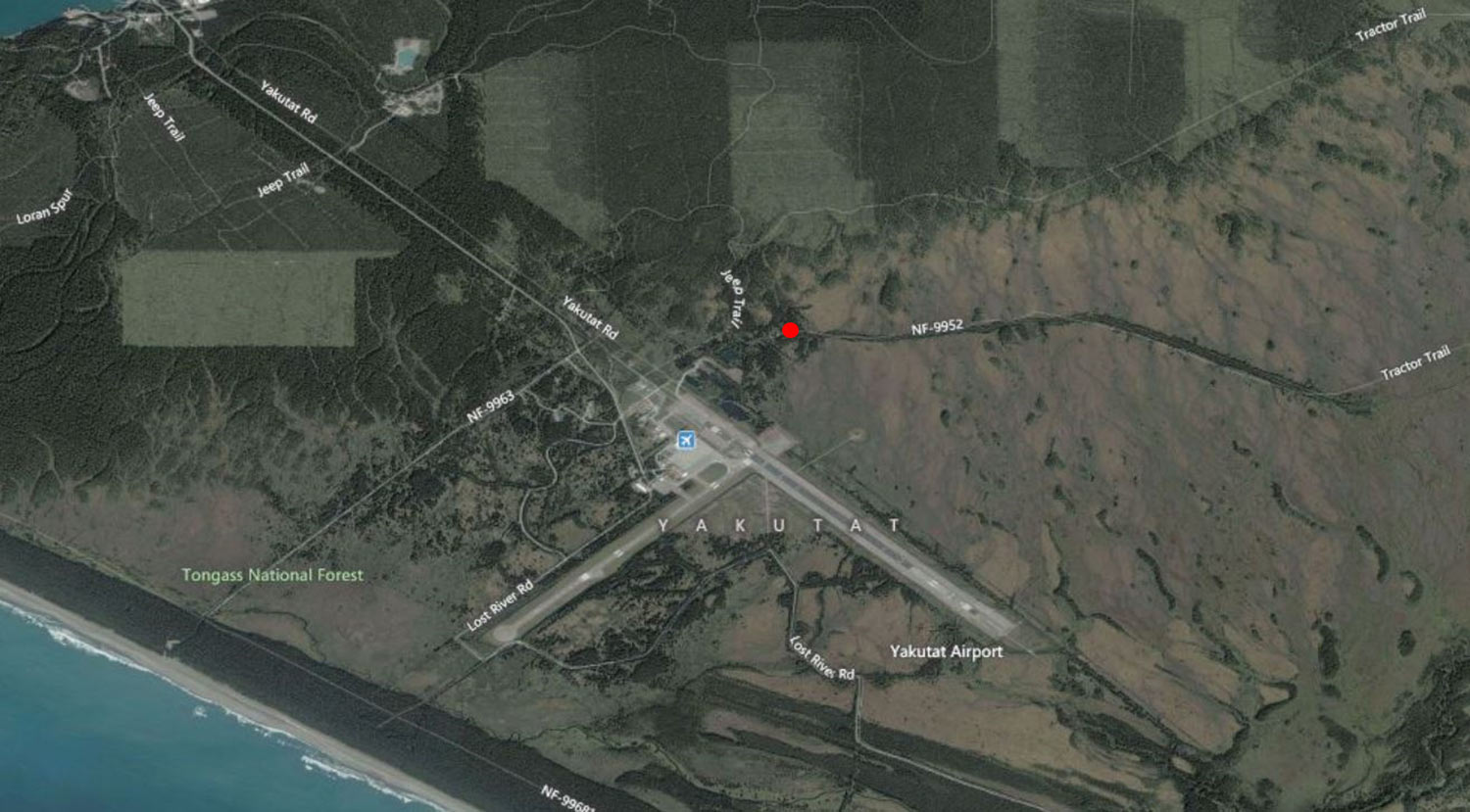
| Yakutat Area | ||
| FH25-I-0008-GP (PDF 607 kB) |
Tsivat River, Tsiu River, Unnamed Streams
Sections 13-24, T. 21 S., R. 14 E., B.R.M. |
See map in permit document |
| Yukon-Tanana River Drainage | FH26-III-0007-GP (PDF 515 kB) |
American Creek
Mission Creek |
Map - American & Mission Creek Crossings (PDF 1,052 kB) | FH26-III-0003-GP (PDF 444 kB) |
Upper Chatanika River
Flat Creek |
Map - Upper Chatanika River Drainage Crossings (PDF 1,450 kB) |
| FH26-III-0002-GP (PDF 617 kB) | North Fork Chena River | Map - North Fork Chena River Crossing (PDF 553 kB) |
| FH26-III-0085-GP (PDF 1,182 kB) |
(Lower) Delta River - Winter Only
|
Map - Delta River Winter Crossings (PDF 1,929 kB) |
| FH26-III-0004-GP (PDF 854 kB) |
Kobe-McGrath Trail
Teklanika River Sushana River Toklat River Bear Paw River |
Map - Kobe-McGrath Trail Crossings (PDF 3,154 kB) |
| FH26-III-0006-GP (PDF 1,151 kB) |
Minook Creek
|
Map - Minook Creek Crossings (PDF 776 kB) |
| FH26-III-0005-GP (PDF 1,252 kB) |
Rex Trail (Windy Creek to Wood River)
|
Rex Trail Crossing Maps (PDF 5,771 kB) |
| FH26-III-0008-GP (PDF 503 kB) |
Tok River
|
Tok River Crossing Maps (PDF 945 kB) |