Areas With Restrictions
Search By Game Management
Unit (GMU)
Note: Use of these maps indicates that you have read and understand the liability statement.
Select a Game Management Unit.
Game Management Unit
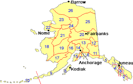
Results for Game Management Unit 19
The following restrictions are those specific to GMU 19. Be sure to check the hunting regulations for additional state-wide hunting and trapping restrictions.
Areas Closed to Hunting
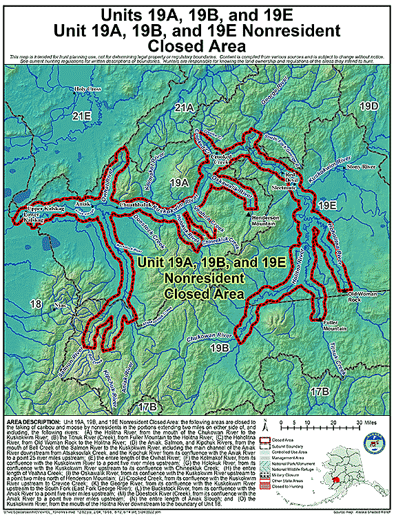
Unit 19(A), 19(B), and 19(E) Nonresident Closed Area
- Restriction: Closed to the taking of caribou and moose by nonresidents
- View Map: GIF Map (143 K) PDF Map (852 K)
- Area Description: Units 19(A), 19(B), and 19(E) Nonresident Closed Area: the following areas are closed to the taking of caribou and moose by nonresidents in the portions extending two miles on either side of, and including, the following rivers:
A. the Holitna River, from the mouth of the Chukowan River to the Kuskokwim River;
B. the Titnuk River, from Fuller Mountain to the Holitna River;
C. the Hoholitna River, from Old Woman Rock to the Holitna River;
D. the Aniak, Salmon, and Kipchuk Rivers, from the mouth of Bell Creek of the Salmon River to the Kuskokwim River, including the main channel of the Aniak River downstream from Atsaksovlak Creek, and the Kipchuk River from its confluence with the Aniak River to a point 25 river miles upstream;
E. the entire length of the Owhat River;
F. the Kolmakof River, from its confluence with the Kuskokwim River to a point five river miles upstream;
G. the Holokuk River, from its confluence with the Kuskokwim River upstream to its confluence with Chineekluk Creek;
H. the entire length of Veahna Creek;
I. the Oskawalik River, from its confluence with the Kuskokwim River upstream to a point two miles north of Henderson Mountain;
J. Crooked Creek, from its confluence with the Kuskokwim River upstream to Crevice Creek;
K. the George River, from its confluence with the Kuskokwim River upstream to the South Fork;
L. the Buckstock River, from its confluence with the Aniak River to a point five river miles upstream;
M. the Doestock River (Creek), from its confluence with the Aniak River to a point five river miles upstream;
N. the entire length of Aniak Slough;
O. and the Kuskokwim River, from the mouth of the Holitna River downstream to the boundary of GMU 18
Controlled Use Areas
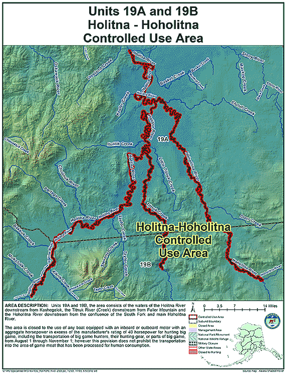
Holitna-Hoholitna Controlled Use Area
- Restriction: The area is closed to the use of any boat equipped with an inboard or outboard motor with an aggregate horsepower in excess of the manufacturer's rating of 40 horsepower for hunting big game, including the transportation of big game hunters, their hunting gear, or parts of big game from August 1 through November 1. However, this provision does not apply to the transportation into the area of game meat that has been processed for human consumption.
- View Map: GIF Map (107 K) PDF Map (460 K)
- Area Description: The Holitna-Hoholitna Controlled Use Area: the area consists of the waters of the Holitna River downstream from Kashegelok, the Titnuk River (Creek) downstream from Fuller Mountain and the Hoholitna River downstream from the confluence of the South Fork and main Hoholitna River
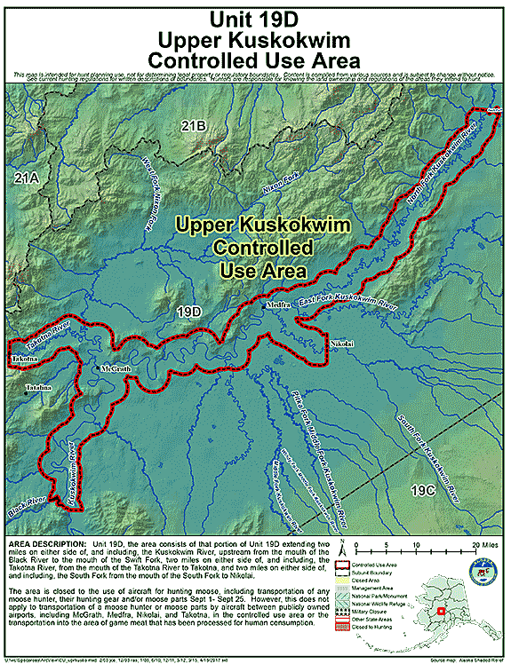
Upper Kuskokwim Controlled Use Area (UKCUA)
- Restriction: The area is closed to the use of aircraft for hunting moose, including the transportation of moose hunters, their hunting gear, or parts of moose from September 1 through September 25; however, this provision does not apply to the transportation of moose hunters, their hunting gear, or parts of moose by aircraft between publicly owned airports, including McGrath, Medfra, Nikolai, and Takotna, or the transportation into the area of game meat that has been processed for human consumption.
- View Map: GIF Map (123 K) PDF Map (462 K)
- Area Description: Upper Kuskokwim Controlled Use Area: The area consists of that portion of Unit 19(D) extending two miles on either side of, and including the Kuskokwim River, upstream from the mouth of the Black River to the mouth of the Swift Fork, extending two miles on either side of, and including, the Takotna River, upstream from the mouth of the Takotna River to Takotna, and extending two miles on either side of, and including, the South Fork River, upstream from the mouth of the South Fork to Nikolai;
Management Areas
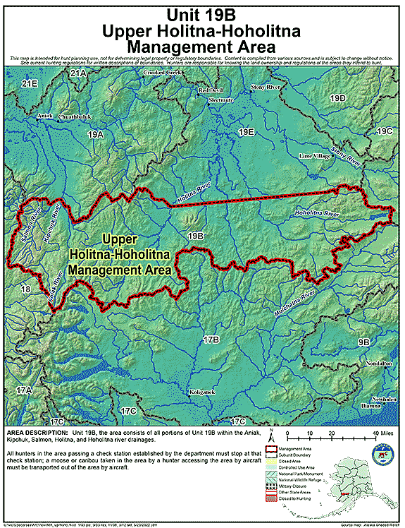
Upper Holitna-Hoholitna Management Area
- Restriction: All hunters in the area passing a check station established by the department must stop at that check station; a moose or caribou taken in the area by a hunter accessing the area by aircraft must be transported out of the area by aircraft.
- View Map: GIF Map (123 K) PDF Map (998 K)
- Area Description: Upper Holitna-Hoholitna Management Area: the area consists of all portions of Unit 19(B) within the Aniak, Kipchuk, Salmon, Holitna and Hoholitna river drainages
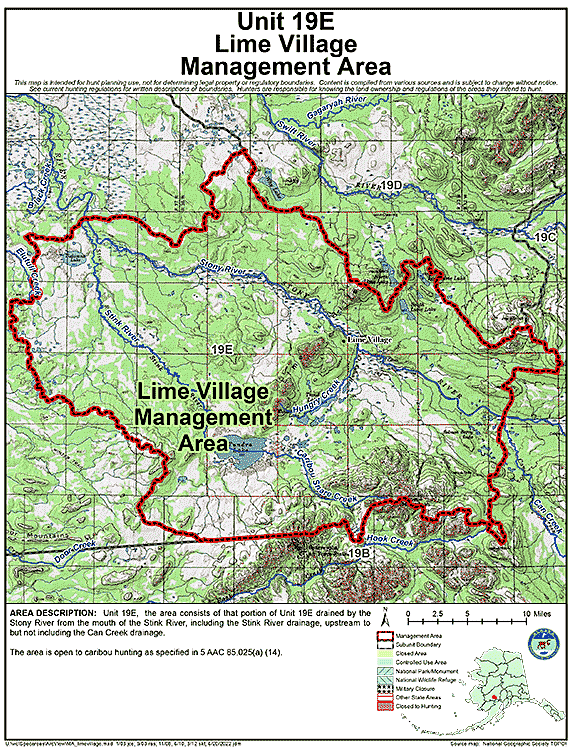
Lime Village Management Area
- Restriction: The area is open to caribou hunting as specified in 5 AAC 85.025(a) (14)
- View Map: GIF Map (144 K) PDF Map (530 K)
- Area Description: Lime Village Management Area: the area consists of that portion of Unit 19(E) drained by the Stony River from the mouth of the Stink River, including the Stink River drainage, upstream to but not including the Can Creek drainage
Note: Changes to area restrictions for hunting and trapping by Emergency Orders may not be shown on this page. Please be sure to check the Emergency Orders page for the most current list of changes.