Controlled Use Areas
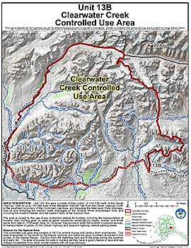
Clearwater Creek Controlled Use Area

Note: Use of these maps indicates that you have read and understand the liability statement.
Units: 13B
Area Description: Unit 13B, the area consists of that portion of Unit 13B north of the Denali Highway, west of up to 100 feet east of the Maclaren Summit Trail from the Denali Highway north to the sourthern boundary of the Controlled Use Area, and including the Maclaren River drainage, east of and including the eastern bank drainages of the Susitna River downstream from and including the Susitna Glacier, and the eastern bank of the Susitna River.
Restrictions: Closed to the use of any motorized vehicle for hunting, including the transportation of hunters, their hunting gear, or parts of game, except for brown/grizzly bears, wolves, and small game from March 15 through June 30; however, this provision does not prohibit motorized access, or transportation of game, on the Denali Highway and adjacent highway vehicle parking areas
