Areas Closed to Hunting
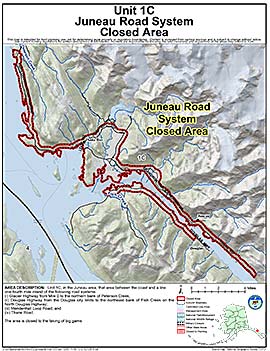
Juneau Road System Closed Area
Note: Use of these maps indicates that you have read and understand the liability statement.
Units: 01C
Area Description: Unit 1C, in the Juneau area, that area between the coast and a line one-fourth mile inland of the following road systems: (i) Glacier Highway from Mile 0 to the northern bank of Peterson Creek; (ii) Douglas Highway from the Douglas city limits to the northeast bank of Fish Creek on the North Douglas Highway; (iii) Mendenhall Loop Road; and (iv) Thane Road.
Restrictions: Closed to the taking of big game