
February 2023
Issue 62
On Ice: Finding Fish in February
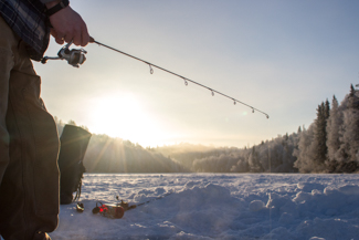 With so many opportunities to get out and go ice fishing, the most challenging part could be determining where to go. For that, we’ve got you covered. Whether you are a season ice fishing angler, or you are new to the activity, the Alaska Lake Database is a great resource to help you find your next fishing spot. If you’re new to ice fishing and don’t have the necessary ice fishing gear, check out our Rod Loaner Program.
Before you head out, be sure you have your 2023 sport fishing license. Visit our online store if you need to purchase one. Or download the ADF&G mobile app and you can store your licenses, tags and permits in your mobile device.
Be sure to follow us on social media. You'll find us on Instagram @wefishak, on Facebook ADF&G - wefishak, and on YouTube.
If you have a comment or story ideas for Reel Times, we encourage you to send them our way. You can send comments to Ryan Ragan.
We'll see you on the water
Dissolved Oxygen and Why it is Important to Ice Fishing
By Donald Arthur and Katelyn Zonneville
Contrary to common belief, fish breathe oxygen and not water. They have well-adapted organs called gills that are designed to extract dissolved oxygen (O2) from water but can also release carbon dioxide (CO2). This process is called respiration and is nearly identical to the way that humans use their lungs to breathe oxygen that is available in the air. Gills are filamentous, meaning they are made of many tiny gill filaments, which increases surface area and allows fish to extract oxygen from the water more efficiently. This respiration process is critical to a fish’s ability to survive, grow, and spawn.
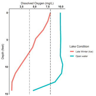
Caption: An example dissolve oxygen-depth profile from Jewel Lake in Anchorage, AK for late-winter conditions (red) and the open water season (blue). The dash lined (8mg/L and greater) represents ideal oxygen levels for trout and salmon. The dot-dashed line (4mg/L and less) represents critical-levels of oxygen that can cause stress and mortality in these species.
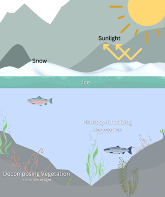
During open water (spring through fall), dissolved oxygen in lake water is at its highest. Aquatic plants and algae can receive enough sunlight during this time of year to photosynthesize. A by-product of photosynthesis is oxygen, which can increase the supply of oxygen in the lake water by aquatic vegetation. Additionally, oxygen can directly be exchanged into water when the lake is directly exposed to the air. For example, wind can churn lakes through wave action and directly force more oxygen into the water.
However, during the late fall when the temperatures drop and the sunlight hours and intensity dwindles, lakes lose these possible sources of oxygen. So, after the first ice forms, the exchange of oxygen between lake and the air is lost and the lake is essentially capped-off with whatever levels of dissolved oxygen it had in the late fall. As snow and ice forms, less and less sunlight reaches the water and aquatic plants; therefore, photosynthesis by plants ceases and plants start to use more oxygen than they produce. With the lack of sunlight, plants will start to die and decompose, further depleting the limited supply of oxygen in iced-over lakes. The further we get into winter; the lower the dissolved oxygen levels will get, particularly towards the lake bottom.
As an angler, you might experience these effects because as the oxygen gets lower and lower during late winter, fish will be higher in the water column, existing where oxygen levels are greater. In some lakes, the fish may become lethargic because of low oxygen (“hypoxic”) conditions, so they may not be feeding and in turn the bite slows down. This may be why you experience better ice fishing success in early winter (December) than late winter (February). This effect of low oxygen tends to impact smaller and shallower lakes like the stocked lakes of Anchorage and the Mat-Su Valley, and it isn’t as much of an issue in larger, deeper lakes (i.e., Lake Louise, Big Lake) and lakes with flow from a creek or river. In the larger, deeper lakes, the lake’s supply of dissolved oxygen is so high that it can overcome these winter effects and lakes with flow are often fed by an oxygen-rich stream.
 In extreme cases, when oxygen drops to critical levels (less than 2-4 mg/L) throughout the whole lake, trout and salmon species will struggle to survive. If trout and salmon species are exposed to these hypoxic conditions for extended periods of time, it can lead to mass mortality events called “winter kills”. This can occur during long and harsh winters when the ice forms early and very thick. While winter kills are rare, even in Alaska, it is still a major possibility in small and shallow lakes. Winter kills have been documented on several lakes throughout Southcentral Alaska every few years. While most lakes do not winterkill, at least not every year, it is more common as an angler you will observe more lethargic fish and a slow bite during late winter in shallow lakes throughout Alaska. Staff from the Alaska Department of Fish and Game opportunistically check dissolved oxygen levels of local stocked lakes through the ice during the winter months.
If you are out ice fishing this winter, be sure to try jigging in different depths of the water column if you are not having luck on the bottom. The fish may have moved up to higher oxygen levels closer to the top of the ice. As the spring sun arrives and some of the snow melts away, sunlight can penetrate the ice and water, allowing plants to photosynthesis again. Once the lakes ice-off, they will finally be replenished with oxygen and kickstart some excellent spring fishing throughout the state.
Southeast Alaska Albacore Tuna
By Craig Schwanke
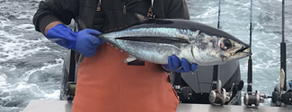 During late August of 2022, some fishermen in Craig, Alaska started monitoring offshore sea temperatures. After a good summer of salmon fishing, they were hoping ocean currents would push warm water into the nearshore waters of the Gulf of Alaska, potentially providing a unique fishing experience. Finally, for the first time since 2015, good ocean conditions with water temperatures in the 60oF range were 20 miles off the western archipelago of Prince of Wales Island. A small number of exploratory power trollers and sport fishermen boated out from Craig to the 1,000-foot contour edge to look for albacore tuna.
Their efforts were rewarded with some sport fishing boats catching over 20 albacore tuna and power trollers catching even larger numbers. Most anglers in Alaska do not have traditional tuna gear as used off the coast of Washington, so Alaskan anglers often troll with modified salmon gear such as hoochies and spoons without flashers attached to heavier bottom fish rods. The key is using a much faster trolling speed than used for salmon fishing. Salmon trolling usually occurs between 2-3 mph whereas tuna prefer 6-8 mph. These schooling fish hit hard at those troll speeds requiring heavier gear. Anglers try to stay on the school and catch multiple fish by trolling or jigging. There is no bag or possession limit for tuna in Alaska, so staying on a school can produce large catches.
There are two populations of albacore tuna in the Pacific Ocean. The North Pacific stock is generally found off the coast of Oregon and Washington, north into British Columbia and occasionally in Alaskan waters. Tuna are finnicky about water temperature and are generally found in water between 58oF and 64oF, which is not common in the Gulf of Alaska. Last summer’s small window of fishing opportunity lasted about 10 days before the warm water dissipated and the tuna were gone. Alaskan tuna anglers will be monitoring sea temperatures again next season and hoping they will not have to wait another seven years before tuna show up once again in Alaska.
Fishing Along the Taylor Highway
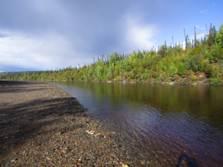 Alaska has relatively few highways compared to other states, but many fishing opportunities lie along these roads. The Taylor Highway, Alaska Route 5, extends a very scenic 160 miles from Tetlin Junction (Mile Post [MP] 1,302 of the Alaska Highway) to the community of Eagle on the Yukon River. The first 60 miles is paved and the remainder is gravel. The Taylor Highway is not maintained during October through April, including snow removal, and is essentially closed to automobile traffic, although it can be popular with snowmachiners. The Taylor Highway connects to the Top of the World Highway at MP 96, allowing access to Dawson City, Yukon Territory in Canada. The Taylor Highway was built in 1953 to provide access to Eagle, Chicken, and the historic Fortymile Mining District, including several access points along the Fortymile River drainage where travelers can take a break from driving and cast a line.
The established waysides are managed through the Bureau of Land Management (BLM) and you can pick up a brochure that describes these and offers advice for people who wish to float between the waysides along the Fortymile Wild and Scenic River. The brochure is available from the BLM office online along with a Taylor Highway specific brochure.
 Most of the Taylor Highway crosses and provides access to headwaters portions of the Fortymile River drainage. Arctic grayling will be the predominant species you can fish for in these waters. King, chum, and coho salmon spawn in this drainage; however, because of recent poor run sizes sport fishing for salmon has been restricted or closed. Therefore, before you target salmon please check with the State of Alaska Department of Fish and Game Emergency Orders and Press Releases. In addition, descriptions of the waysides are given at gofishak. Always carry a current fishing license and have a copy of the current fishing regulations for the Yukon River Drainage. Fishing licenses can be purchased at the ADF&G Online Store.
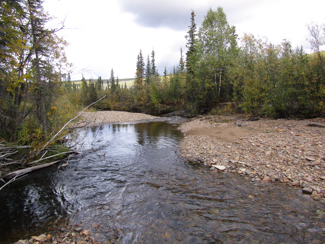
The first wayside at MP 35 is the Mount Fairplay Wayside, which does not provide river access, but can be a good place to view caribou and there is a latrine. This can be a good place to view the Fortymile Caribou Herd, especially during the fall, although caribou can be seen roaming most of the highway’s length. The Logging Cabin Creek Wayside at MP 43 provides access to Logging Cabin Creek, which has crystal-clear water and a picnic area. The next wayside at MP 49 is the West Fork Campground & River Access where floaters can launch a craft to float to downriver waysides and has a campground with 25 campsites. The primitive boat launch accesses the West Fork of the Dennison River, which can be too shallow for pleasant canoeing or rafting. Floats from any wayside to a downriver access point should only be attempted by experienced floaters due to shallow and swift conditions as well as sweepers and rapids. The next wayside is the Mosquito Fork Bridge at MP 64. This wayside has a larger parking area and latrine. However, one will have to walk down a steep, primitive trail before accessing the shallow Mosquito Fork of the Fortymile River. Arctic grayling can often be found in deeper holes near the cutbanks.
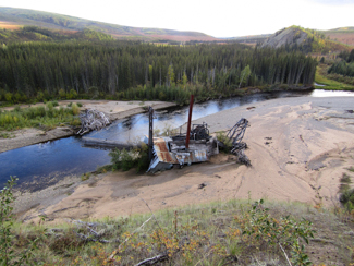
 After fishing at these waypoints, travelers can stop in the historic mining town of Chicken for a bite to eat and you can camp or rent a cabin. Chicken was settled by gold miners in the late 19th century. From local lore, the original name was to be Ptarmigan, due to the prevalence of this bird in the area. However, the spelling could not be agreed upon, so “Chicken” was used instead. Chicken is very small with a year-round population of about 17, with a greater influx during the summer months. Past Chicken the Taylor Highway becomes gravel and can get very rough with potholes and is also narrow in places. You will have to decrease your speed and watch out for other traffic. Also, be aware that there are no services between Chicken and Eagle.
The first wayside past Chicken is the South Fork (Fortymile River) Bridge Wayside at MP 75. This section of the Fortymile River drainage has more water and there are large gravel bars for walking and casting. At MP 82 is the Walker Fork Campground with access to the shallow and clear Walker Fork of the Fortymile River and has a campground with approximately 20 sites. At MP 112 is the Fortymile Bridge Wayside. Here the mainstem of the Fortymile River can be accessed near the bridge and is often used by miners and recreationalists. Although the river is wider with greater flow, be aware that there are rapids located just upriver from the bridge. For those floating the approximately 53 miles to the Yukon River, there are three rapids you will encounter while floating downriver. Again, floating the Fortymile River is not for beginners and float trips will require floating experience and preparation. At MP 160 is the community of Eagle that is located on the mighty Yukon River. The Yukon River receives glacial influence and is occluded and not good for hook and line fishing unless you launch a boat and drive up or downriver to the confluence of a clearwater tributary to cast a line such as approximately 20 miles upriver to the Seventymile River and/or approximately 5 miles downriver to Eagle Creek.
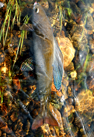 Arctic grayling are voracious, visual predators, and clearwater conditions will provide optimal fishing opportunities. In general, older and larger Arctic grayling will occupy the upper reaches of a river or stream during the summer months, with proportionately larger numbers of smaller adults and juveniles lower in the drainages. Except for the Fortymile Bridge Wayside, most of the Taylor Highway provides access to headwater tributaries and therefore older and larger fish. Popular gear used to capture Arctic grayling are shiny spoons when the streams are wide enough to cast and colorful jigs for narrower streams and creeks. The bag and possession limit for Arctic grayling in the Fortymile River and other upper Yukon River drainages is 5 per day, 5 in possession with no size limit. Like much of Alaska, the Fortymile River drainage is bear country and it is always important wherever you fish to be bear-aware. Here is some information on Traveling in Alaska’s Bear Country.
Because fish typically grow and reproduce more slowly at high latitudes and elevations, please use proper catch-and-release methods to ensure survival of the released fish such as:
- Use lures with a single hook and crimp down the barb. Do not use bait.
- Land the fish with a soft net and keep the fish in the water when removing the hook.
- To release the fish, hold it gently facing into the current or in water without current and gently cradle the fish and move it slowly back and forth until it swims away under its own power.
2023 Changes to Sport Fishing Regulations in the Arctic-Yukon-Kuskokwim Region
The Alaska Board of Fisheries, at the January 14-18 Arctic-Yukon-Kuskokwim meeting in Anchorage, deliberated on 14 and adopted 8 proposals that changed sport fishing regulations in the Arctic-Yukon-Kuskokwim Region for the upcoming fishing season. For more information, please review this press release.
Field to Plate - Recipe of the Month
Recipe of the Month – Garlic Butter Alaska Spot Prawns with Basil and Tomato
 Here’s a delicious recipe for Garlic Butter Alaska Spot Prawns with Basil and Tomato from the Alaska Seafood Marketing Institute.
Enjoy!
If you have any questions about the Reel Times newsletter, please contact Ryan Ragan at ryan.ragan@alaska.gov