Wrangell–St. Elias National Park and Preserve
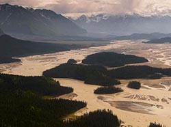
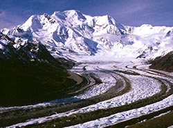
At over 13 million acres, Wrangell St. Elias is America’s largest national park. While characterized by beautiful terrain, it can be challenging for visitors to access viewable wildlife populations, but they are there. The mountain ranges are habitat for Dall sheep, mountain goats, and the Mentasta and Chisana caribou herds. Moose and brown and black bears share the thick growths of shrubbery and berries in low-lying areas. Bison, transplanted to the area decades ago, roam the Copper and Chitina River valleys. Streams and rivers, splayed in wide deltas, serve as migratory corridors for birds such as lesser yellowlegs, wandering tattlers, mallards, pintails, and green-winged teals. The Copper River drainage and Malaspina forelands are prime nesting sites for trumpeter swans. Coastal areas in the southeast corner of the park near Yakutat are inhabited by Steller sea lions, harbor seals, and other marine mammals.
For a high-level view of the park, check out the official Park Map (PDF 5,283 kB) by the National Park Service. The park has two roads leading in and several visitor contact points staffed by rangers with first-hand knowledge of the park:
- Wrangell-St. Elias Visitor Center
- Slana Ranger Station/Nabesna Road
- Chitina Ranger Station/McCarthy Road
Wrangell-St. Elias Visitor Center
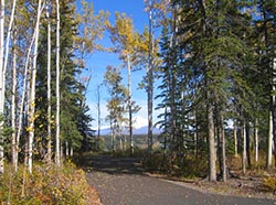
This new facility at Copper Center on the Richardson Highway is the park’s main visitor center although not located within the park boundaries. The center is staffed from April 1 to October 31, hours vary (Call (907)822-7250 for information). This is a great place to stop and talk with park rangers about wildlife viewing opportunities in the park. You can also view a movie about the park, enjoy exhibits, stroll along a short nature trail with a spectacular view of the Wrangell Mountains, and orient yourself with a large 3-D interactive map display. Subsistence fishing and hunt permits are also available here.
Visit the center website at: http://www.nps.gov/wrst/planyourvisit/wrangell-st-elias-visitor-center.htm
Slana Ranger Station/Nabesna Road
The Slana Ranger Station is at .5 mile on the Nabesna Road and is open from April to September, hours vary (Call (907)822-7401 for information).
Nabesna Road is a 42-mile gravel road that takes you to remote areas of the park with great camping, hiking and wildlife viewing. The road traverses the headwaters of the Copper and Tanana river drainages and offers a unique opportunity to explore interior Alaska. Trails leading off the road may be muddy but are generally better heading into the Mentasta Mountains north of the road or past Mile 36.
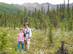
Wildlife viewing can be challenging from Nabesna Road because of the thick brush that grows alongside the road. Your chances increase greatly, however, if you slow down, make frequent stops and use your binoculars to scan the landscape. Red squirrels, Arctic ground squirrels, hares, and voles may be seen darting across the road in summer. Stop at lakes to look for loons, trumpeter swans or other migratory waterfowl. A moose may be standing just off the roadside but their greyish brown fur allows them to blend into the woods, so keep your eyes peeled! The end of Nabesna Road is a beautiful place where there may be sheep viewing opportunities on Boyden Hills or the Wrangell Mountains to the south of the road. You will need a spotting scope, however.
Warning: Visitor services are very limited along the road. High clearance or 4WD vehicles may be needed beyond Mile 29 due to stream crossings. The last four miles of the road are not maintained and are deeply rutted. Call ahead for road conditions.
Chitina Ranger Station/McCarthy Road
The Chitina Ranger Station is located in a log cabin at mile 33 on the Edgerton Highway at the junction of McCarthy Road. The station is open from Memorial Day to Labor Day, hours vary (Call (907)823-2205 for information). You can watch a movie about the park and obtain information about hiking trails and backcountry routes.
The 60-mile McCarthy Road begins just beyond the small town of Chitina after you cross the Copper River Bridge. It’s a rutted gravel road that takes about 3 hours to travel each way, but it can be worth the trip if it’s incredible scenery and vast wilderness that you’re after. The road is narrow and winding and reflects its railroad origins (watch out for old railroad spikes that sometimes surface on the road bed). You will cross several rivers and pass backcountry trailheads. Ask a park ranger for more information.
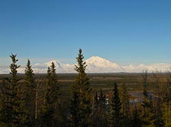
The drive offers beautiful views of the Wrangell and Chugach Mountains and the opportunity to see wildlife such as moose and bear. Copper River salmon runs include sockeye, king and silver salmon in late summer. Chokosna Lake at Mile 25, Moose Lake at Mile 35 and other lakes along the way are great places to stop and look for wildlife. You may see moose, trumpeter swans, bald eagles and, in late summer, salmon.
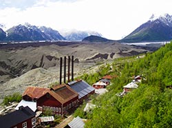
The town of McCarthy still retains much of its past flavor when it was the supply and recreation stop of the Kennecott Mining District. Five miles beyond McCarthy is the Kennecott Mines National Historic Landmark. A park service visitor center is located within the Kennecott Mill Town. The Kennecott Visitor Center is open from Memorial Day to Labor Day (Call (907)554-1105 for information).