Kasilof River — South Bank
Notable Species
- Sockeye salmon
- Harbor seal
- Sandhill crane
- Hudsonian godwit
- Shorebirds
- Bonaparte’s gull
- Mew gull
- Herring gull
- Arctic tern
- Snow bunting
The south bank of the Kasilof River estuary attracts many of the same birds, fish and mammal species as does the north shore. But a more extensive salt marsh reaches further into a bend of the river, and the shoreline may be steeper and less sandy due to greater exposure to Cook Inlet. As the beach curves into the river mouth, the exposure changes from west to north, offering a chance to investigate whether birds have taken shelter during high surf and wind. Sandhill cranes stage and sometimes nest in the marsh, and migrating geese and ducks visit in spring and fall. Shorebirds work the tide line, refueling for migration. In winter, the extensive flats behind the dunes are a favorite haunt of snow buntings. Beluga whales have been seen moving a short distance offshore in pursuit of returning salmon.
Habitat
Several distinct habitats occur relatively close to each other. A tidally influenced beach rims the shore and curves into the river mouth. The estuary draws both marine and freshwater species. The salt marsh with sedges, grass, and brush transitions in a short span to black spruce wetland and then into a lowland forest dominated by white spruce, black cottonwood and paper birch. Extensive edges between open and forested habitat are visible from the mouth.
Recreation Connection
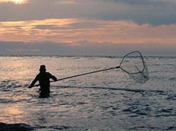
Personal use salmon fishing by Alaska residents draws hundreds of people to the beach each July.
Viewing Tip
High tide concentrates the shore birds, as tides recede they spread out to feed.
Parking can be limited for big vehicles. 4X4 is necessary to drive to the river mouth. Vehicles are only allowed below the mean high water mark. Protect the dunes—don’t drive on them. Avoid trampling vegetation. Respect private property.
Getting There
Sterling Highway milepost 111. Turn right on Cohoe Loop Road and drive west about four miles until the road dead-ends at the beach. The Crooked Creek State Recreation Site is on the right about 1.8 miles from highway.