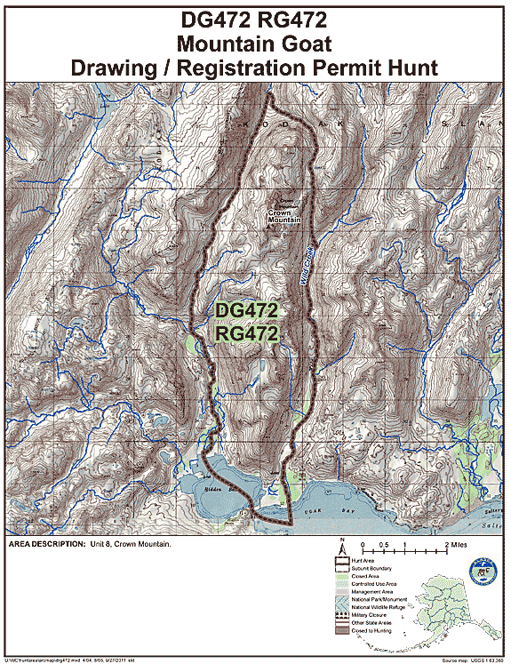
Kodiak Mountain Goat Hunting Area DG/RG 472
Crown Mountain
(USGS Maps - Kodiak C-3 & C-4)
Location:
Northern Kodiak Island, including the west side of the Wild Creek drainage, north extended around Crown Mountain and east of the Hidden Basin Creek drainage. See area map (Image file 146 kB) for more information.
Land Ownership:
Entire hunt area is State land. www.dnr.alaska.gov/mlw/planning/easmtatlas/kodiak/.
Access:
Floatplane access is sometimes possible into Lake 2250' above Hidden Basin if conditions are favorable. The majority of hunters walk in from Hidden Basin especially during the month of October.
Population Trend:
From 2013 to 2017 the population of goats in this area has ranged from 25 to 50 goats.
| Area | Hunt No. | Permits | % Draw (2017) |
|---|---|---|---|
| Crown Mtn. | DG472 | 10 | 6% |
Mountain Goat Harvest Data:
DG472 (Draw Hunt)
| Year | Permits Issued | Hunters Afield | Harvest | % Success |
|---|---|---|---|---|
| 2017 | 12 | 8 | 6 total (4 male, 2 female) | 75% |
| 2016 | 12 | 3 | 2 total (2 male) | 67% |
| 2015 | 12 | 6 | 4 total (3 male, 1 female) | 67% |
| 2014 | 12 | 4 | 3 total (3 male) | 75% |
| 2013 | 13 | 4 | 1 total (1 male) | 25% |
| 2012 | 12 | 5 | 5 total (3 male, 2 female) | 100% |
| 2011 | 12 | 7 | 3 total (2 male, 1 female) | 43% |
| 2010 | 11 | 3 | 3 total (1 male, 2 female) | 100% |
RG472 (Registration Hunt)
| Year | Permits Issued | Hunters Afield | Harvest | % Success |
|---|---|---|---|---|
| 2017 | 0 | 0 | 0 | NA |
| 2016 | 0 | 0 | 0 | NA |
| 2015 | 0 | 0 | 0 | NA |
| 2014 | 0 | 0 | 0 | NA |
| 2013 | 0 | 0 | 0 | NA |
| 2012 | 0 | 0 | 0 | NA |
| 2011 | 0 | 0 | 0 | NA |
| 2010 | 11 | 0 | 0 | NA |