Management Areas
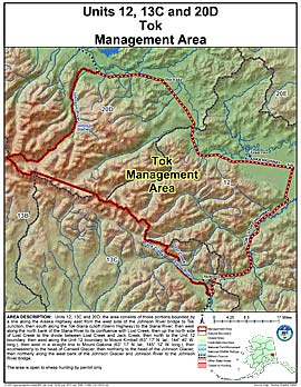
Tok Management Area
Note: Use of these maps indicates that you have read and understand the liability statement.
Units: 12, 13C, 20D
Area Description: Tok Management Area: the area consists of those portions of Units 12, 13(C), and 20(D) bounded by a line along the Alaska Highway east from the west side of the Johnson River bridge to Tok Junction, then south along the Tok-Slana cutoff (Glenn Highway) to the Slana River; then west along the north bank of the Slana River to its confluence with Lost Creek, then up the north side of Lost Creek to the divide between Lost Creek and Jack Creek, then north to the Unit 12 boundary, then west along the Unit 12 boundary to Mount Kimball (63° 17' N. lat., 144° 40' W. long.), then west in a straight line to Mount Gakona (63° 17' N. lat., 145° 12' W. long.), then southwesterly to the head of Canwell Glacier, then northerly to the head of the Johnson Glacier, then northerly along the west bank of the Johnson Glacier and Johnson River to the Johnson River bridge
Restrictions: Open to sheep hunting by permit only