Management Areas
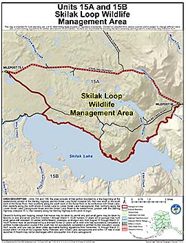
Skilak Loop Wildlife Management Area
Note: Use of these maps indicates that you have read and understand the liability statement.
Units: 15A
Area Description: Skilak Loop Wildlife Management Area: the area consists of that portion of Units 15(A) and 15(B) bounded by a line beginning at the easternmost junction of the Sterling Highway and the Skilak Loop Road (milepost 58), then due south to the south bank of the Kenai River, then southerly along the south bank of the Kenai River to its confluence with Skilak Lake, then westerly along the north shore of Skilak Lake to Lower Skilak Lake Campground, then northerly along the Lower Skilak Lake Campground Road and the Skilak Loop Road to its westernmost junction with the Sterling Highway (milepost 75.1), then easterly along the Sterling Highway to the point of origin
Restrictions: Closed to hunting and trapping, except that moose may be taken by permit only and small game may be taken by falconry or bow and arrow only from October 1 through March 1.
Youth hunters 17 years old or younger may hunt small game with standard .22 caliber rimfire firearm, crossbow, or shotgun only, from August 10 through March 31. Youth hunters must be accompanied by a licensed hunter 21 years old or older who has successfully completed a certified hunter education course if the youth has not successfully completed a certified hunter education course.
Wolf, coyote, and lynx may be taken under applicable hunting regulations from November 10 through March 31, except within 1/4 mile of the Engineer, Kelly, Petersen, and Hidden Lake campgrounds and within 1/4 mile of boat launches.
A firearm may not be discharged within one-quarter mile of any campground.