Management Areas
Palmer-Wasilla Management Area
Note: Use of these maps indicates that you have read and understand the liability statement.
Units: 14A
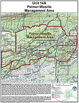
Area Description: Palmer-Wasilla Management Area: the area consists of that portion of Unit 14(A) bounded by a line beginning at the intersection of the George Parks Highway and the Glenn Highway, then east and north along the Glenn Highway to the Palmer Fishhook Road, then west and north along the Palmer Fishhook Road to the Faulk Road intersection, then west along the road and section line to Tex Al Drive and along Tex Al Drive to the Wasilla Fishhook Road, then south along the Wasilla Fishhook Road to Welch Road, then west along Welch Road to the south bank of the Little Susitna River, then west along the south bank of the Little Susitna River to the bridge at North Shushana Drive, then south along North Shushana Drive to Shrock Road, then west along Shrock Road to Church Road, then south along Church Road to the George Parks Highway, then west along the George Parks Highway to Vine Road, then south along Vine Road to Knik Goose Bay Road, then north along Knik Goose Bay Road to Fairview Loop Road, then south and east along Fairview Loop Road to the George Parks Highway, then east along the George Parks Highway to the intersection with the Glenn Highway
Restrictions: The area is closed to hunting except that
1. big game may be taken by muzzleloader, shotguns with slugs, and bow and arrow only;
2. small game, deleterious exotic wildlife, and fur animals may be taken by muzzleloader, shotgun, air rifle, falconry, and bow and arrow only;
3. waterfowl on Finger Lake may be taken by falconry, and bow and flu-flu arrow only;
4. fur animals and furbearers taken under a trapping license by methods other than by trapping or snaring may be taken by muzzleloader, shotgun, air rifle, falconry, or bow and arrow only